Category:Bundok Nagpatong historical marker
Jump to navigation
Jump to search
PHC historical marker for the execution site of Andres Bonifacio at Mount Nagpatong .jpg) | |||||
| Upload media | |||||
| Instance of | |||||
|---|---|---|---|---|---|
| Commemorates |
| ||||
| Location | Bonifacio Shrine and Eco-Tourism Park, Maragondon, Cavite, Calabarzon, Luzon, PH | ||||
| Creator |
| ||||
| Inception |
| ||||
 | |||||
Media in category "Bundok Nagpatong historical marker"
The following 3 files are in this category, out of 3 total.
-
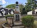 Andres Bonifacio Shrine.jpg 4,000 × 3,000; 4.83 MB
-
 Bundok Nagpatong Historical Marker (cropped).jpg 653 × 1,075; 473 KB
-
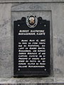 Bundok Nagpatong Historical Marker.jpg 1,072 × 1,430; 851 KB

