Category:Bulkemstraat 41, Simpelveld
Jump to navigation
Jump to search
| Object location | | View all coordinates using: OpenStreetMap |
|---|
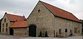
building in Bulkemsbroek near Simpelveld, Netherlands  | |||||
| Upload media | |||||
| Instance of | |||||
|---|---|---|---|---|---|
| Location | Bulkemsbroek, Simpelveld, Limburg, Netherlands | ||||
| Street address |
| ||||
| Located on street |
| ||||
| Heritage designation |
| ||||
 | |||||
|
This is a category about rijksmonument number 33587
|
| Address |
|
Media in category "Bulkemstraat 41, Simpelveld"
The following 4 files are in this category, out of 4 total.
-
 Hoeve Bulkem.JPG 4,288 × 3,216; 2.92 MB
-
 Simpelveld Bulkemstraat 41.jpg 2,664 × 1,262; 721 KB
-
 Simpelveld-Bulkemstraat 41 (1).JPG 4,000 × 3,000; 4.61 MB
-
 Simpelveld-Bulkemstraat 41 (2).JPG 4,000 × 3,000; 4.59 MB

.JPG)
.JPG)