Category:Buitenhof 37, The Hague (De Vijverhof)
Jump to navigation
Jump to search
| Object location | | View all coordinates using: OpenStreetMap |
|---|
building in The Hague, Netherlands  | |||||
| Upload media | |||||
| Instance of | |||||
|---|---|---|---|---|---|
| Location | The Hague, South Holland, Netherlands | ||||
| Located on street |
| ||||
| Heritage designation |
| ||||
 | |||||
|
This is a category about rijksmonument number 17490
|
| Address |
|
Media in category "Buitenhof 37, The Hague (De Vijverhof)"
The following 28 files are in this category, out of 28 total.
-
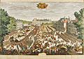 's-Gravenhage (Haagse Kermis) - Daniel Marot.jpg 3,331 × 2,343; 2.23 MB
-
 1758. Gezicht van het Buyten Hof.png 5,096 × 3,641; 6.94 MB
-
 1825, Buitenhof, The Hague.png 1,761 × 1,031; 3 MB
-
 Achtergevel - 's-Gravenhage - 20088301 - RCE.jpg 963 × 1,200; 320 KB
-
 Buitenhof Noyelles Huis.jpg 2,816 × 2,112; 1.84 MB
-
 Buitenhof, Den Haag, Netherlands - panoramio (22).jpg 4,896 × 3,264; 6.22 MB
-
 Den Haag - 17e-eeuws gebouw Vijverhof - Buitenhof.jpg 1,280 × 960; 932 KB
-
 Den Haag - Buitenhof 37.JPG 4,592 × 3,056; 5.63 MB
-
 Exterieur OVERZICHT VOORGEVELS - 's-Gravenhage - 20262300 - RCE.jpg 1,200 × 799; 187 KB
-
 Gezicht op Gevangenpoort - 's-Gravenhage - 20086289 - RCE.jpg 1,200 × 841; 224 KB
-
 Kadastergebouw - 's-Gravenhage - 20088300 - RCE.jpg 804 × 1,200; 164 KB
-
 Kortenbos, Den Haag, Netherlands - panoramio (1).jpg 2,048 × 1,375; 750 KB
-
 Kortenbos, Den Haag, Netherlands - panoramio (59).jpg 4,896 × 3,264; 6.28 MB
-
 Origineel in bezit van Gemeente Archief - 's-Gravenhage - 20085757 - RCE.jpg 960 × 1,200; 465 KB
-
 Origineel in bezit van Gemeente Archief - 's-Gravenhage - 20085758 - RCE.jpg 956 × 1,200; 432 KB
-
 Overzicht - 's-Gravenhage - 20085759 - RCE.jpg 1,200 × 804; 197 KB
-
 Overzicht - 's-Gravenhage - 20088269 - RCE.jpg 1,200 × 956; 214 KB
-
 Overzicht - 's-Gravenhage - 20088288 - RCE.jpg 1,200 × 804; 165 KB
-
 Overzicht - 's-Gravenhage - 20088297 - RCE.jpg 1,200 × 960; 306 KB
-
 Overzicht - 's-Gravenhage - 20090912 - RCE.jpg 1,200 × 804; 154 KB
-

-

-
 Return of the art collection of the Stadtholder, 14 november 1815.jpg 3,544 × 2,127; 2.38 MB
-
 Rm17490.JPG 3,648 × 2,736; 1.93 MB
-
 Voor en zijgevel - 's-Gravenhage - 20085761 - RCE.jpg 1,200 × 797; 239 KB
-
 Voor- en rechter zijgevel - 's-Gravenhage - 20088299 - RCE.jpg 1,200 × 955; 248 KB
-
 Voorgevel - 's-Gravenhage - 20085760 - RCE.jpg 1,200 × 800; 222 KB
-
 Voorgevel - 's-Gravenhage - 20088298 - RCE.jpg 1,200 × 953; 279 KB
_-_Daniel_Marot.jpg)


.jpg)


.jpg)
.jpg)


