Category:Buildings in Tring
Jump to navigation
Jump to search
Subcategories
This category has the following 18 subcategories, out of 18 total.
C
- Cafés in Tring (6 F)
F
- Fire stations in Tring (10 F)
G
- Gatehouse to Sutton Court (10 F)
H
M
- Markets in Tring (6 F)
P
R
S
- Squares in Tring (10 F)
- Summer House, Tring Park (8 F)
T
- The Counting House, Tring (9 F)
- The Market House, Tring (2 F)
- Tring Co-operative Society (3 F)
- Tring Local History Museum (3 F)
Media in category "Buildings in Tring"
The following 79 files are in this category, out of 79 total.
-
 "The Cog" cafe in Frogmore Street, Tring - geograph.org.uk - 5802527.jpg 3,648 × 2,736; 898 KB
-
 "This way to the Zoological Museum" - geograph.org.uk - 1611688.jpg 624 × 640; 107 KB
-
 14 Akeman Street, Tring, June 2022.jpg 4,032 × 3,024; 4.44 MB
-
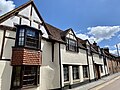
 16 and 17 High Street, Tring, June 2022.jpg 3,024 × 4,032; 4.28 MB
-
 20 Park Street, Tring, September 2019.jpg 4,032 × 3,024; 2.93 MB
-
 21 and 22 Park Street, Tring, June 2022.jpg 4,032 × 3,024; 5.09 MB
-
 23 and 24 Park Street, Tring, June 2022.jpg 4,032 × 3,024; 5.07 MB
-
 25 and 25a High Street, Tring, June 2022.jpg 4,032 × 3,024; 4.14 MB
-
 25 and 26 Park Street, Tring, June 2022.jpg 3,024 × 4,032; 4.23 MB
-
 5, 6 and 7 Park Street, Tring, June 2022.jpg 4,032 × 3,024; 4.44 MB
-
 89 and 90 Akeman Street, Tring, June 2022.jpg 4,032 × 3,024; 4.74 MB
-

-
 Chiltern Way, Tring - geograph.org.uk - 1573858.jpg 640 × 480; 98 KB
-
 Chiltern Way, Tring - geograph.org.uk - 1573860.jpg 640 × 480; 115 KB
-
 Church Yard, Tring - geograph.org.uk - 1594495.jpg 640 × 480; 124 KB
-
 Church Yard, Tring - geograph.org.uk - 1594497.jpg 480 × 640; 93 KB
-
 Demolition, No.100 Grove Road, Tring - geograph.org.uk - 1610706.jpg 640 × 467; 71 KB
-

-
 Fanlight Window, Church Yard, Tring - geograph.org.uk - 1594504.jpg 480 × 640; 124 KB
-
 Farm barns at West Leith - geograph.org.uk - 530824.jpg 640 × 480; 91 KB
-

-
 Flats, from Pond Close, Tring - geograph.org.uk - 1602813.jpg 640 × 480; 105 KB
-
 Flats, from Pond Close, Tring - geograph.org.uk - 1602814.jpg 640 × 504; 130 KB
-
 Flats, Western Road, Tring - geograph.org.uk - 1601427.jpg 640 × 508; 111 KB
-

-
 Gable-End, Tring - geograph.org.uk - 1484367.jpg 640 × 473; 81 KB
-
 Gable-Roofed Porch at Tring. - geograph.org.uk - 1483651.jpg 543 × 640; 106 KB
-
 Gamnel Farm, Bulbourne Road, Tring - After the fire - geograph.org.uk - 1220981.jpg 2,448 × 3,264; 3.9 MB
-
 GOC Tring & Wendover Woods 132 31 Frogmore Street, Tring (34563136370).jpg 3,959 × 2,975; 4.2 MB
-
 High Street, Tring - geograph.org.uk - 1484358.jpg 640 × 470; 63 KB
-
 High Street, Tring - geograph.org.uk - 1484389.jpg 591 × 640; 79 KB
-
 High Street, Tring, Hertfordshire - geograph.org.uk - 1482007.jpg 640 × 480; 77 KB
-
-

-

-
 Lock-up Garages, Tring - geograph.org.uk - 1573766.jpg 640 × 480; 183 KB
-
 Lock-up Garages, Tring - geograph.org.uk - 1573768.jpg 640 × 480; 164 KB
-
 Lock-up Garages, Tring - geograph.org.uk - 1573769.jpg 640 × 480; 182 KB
-
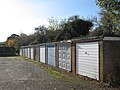 Lock-up Garages, Tring - geograph.org.uk - 1573772.jpg 640 × 480; 147 KB
-
 Lock-up Garages, Tring - geograph.org.uk - 1573773.jpg 640 × 480; 177 KB
-
 Lock-up Garages, Tring - geograph.org.uk - 1573774.jpg 640 × 480; 143 KB
-
 Lock-up Garages, Tring - geograph.org.uk - 1573775.jpg 640 × 480; 131 KB
-
 Marshcroft Farm, Tring - geograph.org.uk - 1454091.jpg 640 × 480; 59 KB
-
 Massey House, Brook Street, Tring - geograph.org.uk - 1602791.jpg 640 × 521; 99 KB
-
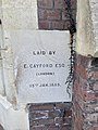
 Obelisk in memory of James Page, Akeman Street Baptist Church, Tring, June 2022.jpg 3,024 × 4,032; 6.01 MB
-
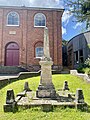 Obelisk in memory of Richard Glover, Akeman Street Baptist Church, Tring, June 2022.jpg 3,024 × 4,032; 5.8 MB
-

-

-
 Old Church House, Western Road, Tring - geograph.org.uk - 1601119.jpg 640 × 484; 106 KB
-
 Old Lamppost, Corner of Windmill Way - geograph.org.uk - 671299.jpg 480 × 640; 159 KB
-
 Park Hill Farm - geograph.org.uk - 1454183.jpg 640 × 427; 69 KB
-

-
 Public Toilets, Tring - geograph.org.uk - 1594485.jpg 640 × 480; 122 KB
-
 Rear of 26 High Street, Tring, June 2022.jpg 4,032 × 3,024; 4.16 MB
-

-
 Sports Centre, Tring - geograph.org.uk - 1576852.jpg 640 × 487; 104 KB
-
 Sports Centre, Tring - geograph.org.uk - 1576853.jpg 640 × 480; 114 KB
-
 Sports Centre, Tring - geograph.org.uk - 1576854.jpg 640 × 480; 95 KB
-
-

-

-
 The Granary, Marshcroft Lane, Tring - geograph.org.uk - 1454137.jpg 640 × 480; 65 KB
-
 Tile-hung Wall at Tring - geograph.org.uk - 1480849.jpg 480 × 640; 145 KB
-
 Tring Community Centre - geograph.org.uk - 1239467.jpg 640 × 480; 145 KB
-
 Tring Community Centre, Silk Mill - geograph.org.uk - 1602808.jpg 640 × 480; 137 KB
-
 Tring High Street - geograph.org.uk - 1483579.jpg 521 × 640; 86 KB
-
 Tring High Street.jpg 509 × 287; 34 KB
-
 Tring LHM1.JPG 3,648 × 2,736; 3.57 MB
-
 Tring Telephone Exchange - geograph.org.uk - 987676.jpg 640 × 480; 61 KB
-
 Tring, June 2022 04.jpg 3,024 × 4,032; 3.68 MB
-
 Tring, June 2022 05.jpg 4,032 × 3,024; 4.05 MB
-
 Tring, June 2022 08.jpg 3,024 × 4,032; 3.27 MB
-
 Tring, June 2022 13.jpg 3,024 × 4,032; 6 MB
-
 Tring, June 2022 14.jpg 4,032 × 3,024; 5.38 MB
-
 Tring, June 2022 24.jpg 3,024 × 4,032; 4.98 MB
-
 Vestry Hall, Church Yard, Tring - geograph.org.uk - 1596901.jpg 470 × 640; 79 KB
-
 Vestry Hall, Church Yard, Tring - geograph.org.uk - 1596902.jpg 480 × 640; 104 KB
-
 Victoria Hall, Tring - geograph.org.uk - 1483830.jpg 509 × 640; 84 KB
-
 Zoological Museum sign.jpg 2,048 × 1,536; 583 KB


.jpg)


,_Tring_-_geograph.org.uk_-_1596905.jpg)


,_Akeman_Street,_Tring,_June_2022.jpg)


