Category:Buildings in Sheffield
Jump to navigation
Jump to search
| Upload media | |||||
| Location |
| ||||
|---|---|---|---|---|---|
| |||||
Subcategories
This category has the following 24 subcategories, out of 24 total.
*
A
- Arnold Laver (3 F)
D
- Damflask Reservoir lodge (8 F)
- Don Valley Stadium (10 F)
F
- Fire stations in Sheffield (5 F)
G
- Gripples factory, Sheffield (3 F)
H
L
- The Leadmill, Sheffield (12 F)
M
- Madina Mosque (9 F)
O
- Onesacre Hall (3 F)
S
- Sheffield Business Park (2 F)
- Sheffield Digital Campus (6 F)
- Sheffield Incinerator (1 F)
- Sheffield Law Courts (4 F)
Media in category "Buildings in Sheffield"
The following 145 files are in this category, out of 145 total.
-
 "Cricket Inn" framed by a football goalpost - geograph.org.uk - 4398548.jpg 4,799 × 3,504; 4.05 MB
-
 "Cricket Inn", Totley Bents - geograph.org.uk - 4398552.jpg 4,960 × 3,624; 3.57 MB
-
 "Ghost sign", City Wharf, Sheffield - geograph.org.uk - 2883867.jpg 848 × 1,024; 209 KB
-
 "Ghost sign", Devonshire Street, Sheffield - geograph.org.uk - 2885120.jpg 681 × 1,024; 192 KB
-
 "Ghost sign", Eyre Lane, Sheffield - geograph.org.uk - 2883756.jpg 681 × 1,024; 168 KB
-
 "Men Zone" Hairdressing Salon, Mansfield Road, Sheffield - geograph.org.uk - 2580095.jpg 2,608 × 1,952; 1.39 MB
-
 "One Ash" - Grand detached house on Dore Road, Sheffield - geograph.org.uk - 2562134.jpg 2,425 × 1,819; 1.35 MB
-
 "Riverdale", Graham Road, Sheffield - geograph.org.uk - 2977441.jpg 3,774 × 2,696; 2.12 MB
-
 "The Cheese-Grater", Sheffield, Charles Street car park - geograph.org.uk - 3037892.jpg 1,064 × 1,600; 358 KB
-

-
 "The Cheesegrater", Sheffield - geograph.org.uk - 3759440.jpg 4,858 × 3,886; 4.67 MB
-
 "The Closed Shop", Commonside, Sheffield 10 - geograph.org.uk - 2126314.jpg 2,484 × 1,856; 1.29 MB
-
 "The Greystones", Sheffield 11 - geograph.org.uk - 3568444.jpg 3,500 × 2,625; 1.7 MB
-
 "The Hallamshire House" at Commonside, Sheffield 10 - geograph.org.uk - 2126320.jpg 2,608 × 1,952; 1.17 MB
-
 "The Psalter", Psalter Lane, Sheffield - geograph.org.uk - 3242765.jpg 4,360 × 2,907; 2.77 MB
-
 "The Rock" on Rock Street, Burngreave - geograph.org.uk - 2601641.jpg 2,250 × 1,688; 905 KB
-
 "The Shiny Sheff" shining in the sunshine - geograph.org.uk - 2120149.jpg 2,608 × 1,952; 1.39 MB
-

-

-

-
 -i---i- (5454793202).jpg 2,592 × 2,592; 2.95 MB
-
 -i---i- (5536156170).jpg 3,240 × 2,592; 2.81 MB
-
 -i---i- (6347901631).jpg 3,140 × 2,512; 1.23 MB
-
 1 Haymarket, Sheffield - geograph.org.uk - 3882988.jpg 640 × 557; 187 KB
-
 1 St James's Row, Sheffield - geograph.org.uk - 3874987.jpg 640 × 566; 216 KB
-
 1 Steel Road, Sheffield 11 - geograph.org.uk - 5251213.jpg 4,795 × 3,788; 4.38 MB
-
 104 Mary Street.jpg 1,920 × 2,560; 1.67 MB
-
 11-31 Fargate, Sheffield - geograph.org.uk - 3883257.jpg 574 × 640; 192 KB
-

-
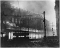 13th December 1940- Sheffield blitz - NARA - 196508.jpg 3,000 × 2,388; 3.22 MB
-
 18-22 Page Hall Road.jpg 1,920 × 2,560; 1.4 MB
-
 19-20 George Woofindin Almshouses.JPG 1,105 × 1,252; 319 KB
-
 22A Norfolk Row - geograph.org.uk - 2886737.jpg 1,024 × 768; 197 KB
-
 24 hour recovery - geograph.org.uk - 2038925.jpg 640 × 483; 117 KB
-
 285 Glossop Road - geograph.org.uk - 3081261.jpg 480 × 640; 91 KB
-
 38-40 Fargate, Sheffield.jpg 1,647 × 2,677; 1.01 MB
-
 40 Leamington Street, Crookes, Sheffield 10 - geograph.org.uk - 2126303.jpg 1,778 × 2,378; 1.11 MB
-
 45 Marlborough Road, Broomhill, Sheffield - 1 - geograph.org.uk - 3464594.jpg 2,387 × 2,058; 2.17 MB
-
 45 Marlborough Road, Broomhill, Sheffield - 2 - geograph.org.uk - 3464598.jpg 2,515 × 2,058; 2.43 MB
-
 45 Marlborough Road, Broomhill, Sheffield - 3 - geograph.org.uk - 3464607.jpg 1,733 × 2,131; 1.89 MB
-
 458 Fulwood Road.jpg 2,560 × 1,920; 2.18 MB
-
 7 - 10 Norton Hammer Lane.jpg 2,560 × 1,920; 1.81 MB
-
 90 Arundel Street - geograph.org.uk - 2957495.jpg 553 × 640; 97 KB
-
 94-100 Milton Street.jpg 2,560 × 1,920; 1.31 MB
-
 95 Harcourt Road, Sheffield 10 - geograph.org.uk - 2126331.jpg 1,792 × 2,399; 848 KB
-

-
-
 A building in Sandygate - geograph.org.uk - 3078473.jpg 800 × 600; 142 KB
-

-
 Abbeydale Cinema (detail) - geograph.org.uk - 1977411.jpg 640 × 426; 60 KB
-
 Abbeydale Cinema - Snooker 26-03-06.jpg 600 × 480; 55 KB
-
 Abbeydale House.JPG 2,560 × 1,920; 499 KB
-

-
-
 Attercliffe Chapel.jpg 3,104 × 1,746; 2.5 MB
-
 Baan Thai Restaurant.jpg 2,560 × 1,920; 1.38 MB
-
 BBC Radio Sheffield, Shoreham Street (geograph 5844248).jpg 1,024 × 683; 194 KB
-
 Beulah Kop.jpg 1,920 × 2,560; 1.34 MB
-
-

-
 Bioincubator.jpg 2,592 × 1,944; 1.5 MB
-
 Bloki w Sheffield.jpg 4,608 × 3,456; 2.57 MB
-
 Building the amphitheatre - geograph.org.uk - 3672086.jpg 2,848 × 2,144; 1.54 MB
-
 Busy street, busy skyline - geograph.org.uk - 1367063.jpg 640 × 480; 58 KB
-
 Cadbury factory at Beulah Road, Sheffield, England.jpg 640 × 480; 64 KB
-

-
 City Life Centre - geograph.org.uk - 979318.jpg 640 × 426; 103 KB
-
 Confluence of Don & Sheaf.jpg 1,000 × 600; 153 KB
-
 Cornish Works.JPG 2,560 × 1,920; 2.17 MB
-
 Corporation Nightclub, Sheffield, June 2017.jpg 1,280 × 960; 224 KB
-
 English Pewter Company.jpg 3,104 × 1,746; 1.69 MB
-

-
 Factory alongside mill goit - geograph.org.uk - 1760470.jpg 518 × 389; 174 KB
-
 Firths Norfolk West Gun Shop (front).jpg 3,104 × 1,746; 1.6 MB
-
 Firths Norfolk West Gun Shop (rear).jpg 3,104 × 1,746; 1.7 MB
-
 Fulwood House.jpg 3,264 × 2,532; 1.81 MB
-
 G. S. Dilley and Sons Warehouse.jpg 2,408 × 1,547; 404 KB
-

-
 Gasometer, crane and new cars - geograph.org.uk - 1714141.jpg 640 × 483; 51 KB
-
 Gatecrasher site feb2008.jpg 2,048 × 1,536; 502 KB
-
 Greystones Hall.jpg 2,560 × 1,920; 1.62 MB
-

-
 Henderson's Relish building 2012 1.jpg 3,264 × 2,448; 2.25 MB
-
 Henderson's Relish building 2012 2.jpg 3,264 × 2,448; 2.34 MB
-
 Henderson's Relish building 2012 3.jpg 3,264 × 2,448; 2.19 MB
-
 Henderson's Relish factory - geograph.org.uk - 787301.jpg 640 × 480; 78 KB
-

-
 KelhamBrewery.jpg 3,210 × 1,758; 1,005 KB
-
 Kenilworth Works.jpg 2,560 × 1,920; 1.5 MB
-
 King Edwards hospital 2.JPG 3,648 × 2,736; 2.74 MB
-
 Kutrite Works.jpg 2,560 × 1,920; 1.72 MB
-
 Meersbrook Vestry Hall.jpg 2,560 × 1,920; 1.65 MB
-
 Montague House east front.jpg 2,560 × 1,920; 1.5 MB
-
 Montague House west front.jpg 2,560 × 1,920; 1.91 MB
-
 Moore Street Electricity Substation.jpg 1,920 × 2,560; 988 KB
-
 More Hall Reservoir - geograph.org.uk - 1056328.jpg 480 × 640; 106 KB
-
 Murray Building, Sheffield.jpg 1,920 × 2,560; 1.66 MB
-
 Nick Bax at Park Hill Sheffield.jpg 500 × 379; 119 KB
-
 North Gallery, Sheffield - geograph.org.uk - 725360.jpg 640 × 428; 89 KB
-
 Number 19 Shrewsbury Road Listed Building.jpg 5,504 × 3,096; 9.71 MB
-
 Octagon 1.jpg 2,592 × 1,944; 1.62 MB
-
 Orangery and Colonnade, Norton Hall.jpg 3,024 × 2,160; 3.12 MB
-
 Parade Chambers, carvings.jpg 2,633 × 1,889; 886 KB
-
 Paradise Square (28055437336).jpg 2,463 × 3,448; 6.37 MB
-
 Park Hill Flats, Sheffield (6655748683).jpg 3,648 × 2,736; 5.08 MB
-
 Persistence Works, Brown Street, Sheffield (geograph 3897015).jpg 634 × 640; 149 KB
-
 Poundland building in Sheffield 19th January 2020.jpg 3,456 × 4,608; 4.91 MB
-
 President Works Offices.jpg 3,104 × 1,746; 1.67 MB
-
 Revenge of the cheesegrater (6532506913).jpg 4,437 × 2,805; 5.8 MB
-
 Royal Victoria Hotel - geograph.org.uk - 972796.jpg 640 × 480; 108 KB
-
 Royal Victoria Hotel - geograph.org.uk - 972815.jpg 640 × 480; 68 KB
-
 School96.jpg 1,944 × 1,296; 262 KB
-
 Schoolside.jpg 2,048 × 1,536; 588 KB
-
 Sewer Gas Lamp, Leavy Greave Road.JPG 1,920 × 2,560; 2.61 MB
-
 Sheaf Quay (27473726433).jpg 2,485 × 3,132; 6.57 MB
-
 Sheaf Street, Sheffield - geograph.org.uk - 724209.jpg 640 × 428; 95 KB
-
 "Eye-Witness" Works Milton St - Sheffield - geograph.org.uk - 356949.jpg 640 × 480; 104 KB
-
 Sheffield (28133977855).jpg 1,823 × 2,552; 3.96 MB
-
 Sheffield - The Nichols Building - geograph.org.uk - 1424849.jpg 640 × 480; 96 KB
-
 Sheffield Central Switching Station (5454793190).jpg 3,240 × 2,459; 2.91 MB
-
 Sheffield Incinerator.jpg 2,048 × 1,536; 552 KB
-
-
 Sheffield School Board sign on the old Anns Grove School, Heeley, (now Sum Studios).jpg 2,256 × 1,496; 856 KB
-
 Sheffield Transmitter, viewed from the north, Aug 2011,.jpg 3,240 × 4,320; 2.7 MB
-
 Sikh Temple in Grimesthorpe - geograph.org.uk - 846233.jpg 640 × 427; 143 KB
-

-

-
 Sheffield, South Yorkshire Police HQ - geograph.org.uk - 796515.jpg 640 × 480; 55 KB
-
 ShirebrookValleyVisitorsCenter.jpg 3,648 × 2,736; 4.28 MB
-
 Shops on Lowedges Road (geograph 5054393).jpg 640 × 480; 57 KB
-
 South Yorkshire Fire and Rescue Service HQ.png 867 × 657; 1.15 MB
-
 South Yorkshire Police headquarters, Sheffield.jpg 631 × 386; 246 KB
-
 South Yorkshire Police Headquarters, Snig Hill (geograph 2894648).jpg 640 × 480; 287 KB
-
 Spot the ghost - geograph.org.uk - 723994.jpg 640 × 401; 45 KB
-
 Stanley Tools, Rutland Road Site, Sheffield - 2 - geograph.org.uk - 1762141.jpg 2,576 × 1,932; 965 KB
-
 Taylors Ceylon Works.jpg 2,560 × 1,920; 1.13 MB
-

-
 THE WELLINGTON SHEFFIELD MARCH 2012 (6987144645).jpg 2,847 × 2,138; 2 MB
-

-
 The WIck At Both Ends (29147634573).jpg 2,050 × 2,355; 3.48 MB
-
 Thirwell Road Bakery.jpg 2,560 × 1,920; 1.24 MB
-
 Tower block with cladding exposed in Sheffield 2017.jpg 2,552 × 1,728; 951 KB
-
 Water Works (28035674771).jpg 3,460 × 2,241; 6.48 MB
-

-
 Holly House, Low Road, Oughtibridge - geograph.org.uk - 765077.jpg 640 × 480; 84 KB


,_Bole_Hill_Road,_Walkley,_Sheffield_-_5_-_geograph.org.uk_-_2031609.jpg)

.jpg)
.jpg)
.jpg)


_-_geograph.org.uk_-_1977411.jpg)


.jpg)


.jpg)
.jpg)


.jpg)


.jpg)
.jpg)
.jpg)


.jpg)


.jpg)


.jpg)

.jpg)


.jpg)


.jpg)


.jpg)


.jpg)

.jpg)


.jpg)

