Category:Buildings in Farnley, West Yorkshire
Jump to navigation
Jump to search
Subcategories
This category has the following 13 subcategories, out of 13 total.
- Shops in Farnley, Leeds (11 F)
C
F
- Farnley Wood Farm (8 F)
H
- Harper Farm, Farnley (1 F)
L
M
P
V
- Village Chippy, Low Moor Side (13 F)
W
- Wellholme Cottage, Farnley (16 F)
- Wood End Farm, New Farnley (10 F)
Media in category "Buildings in Farnley, West Yorkshire"
The following 21 files are in this category, out of 21 total.
-
 Butt Lane gas installation - geograph.org.uk - 6439231.jpg 1,024 × 768; 378 KB
-
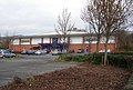
 Buzz Bingo, Stonebridge Lane - geograph.org.uk - 6483372.jpg 1,024 × 768; 138 KB
-
 Corn Mill Yard, Pudsey Road - geograph.org.uk - 4680792.jpg 1,024 × 768; 563 KB
-
 Demolished social club, Farnley (1) - geograph.org.uk - 4715140.jpg 1,024 × 768; 894 KB
-
 Demolished social club, Farnley (2) - geograph.org.uk - 4715144.jpg 1,024 × 768; 720 KB
-

-
 Entrance to the Methodist Sunday School, Farnley - geograph.org.uk - 2465254.jpg 1,523 × 2,000; 726 KB
-

-
 Former Workshops, Stonebridge Mill.jpg 1,024 × 768; 223 KB
-
 Gala Bingo - Silver Royd Hill - geograph.org.uk - 622132.jpg 640 × 431; 42 KB
-
 Guilder's Cottage, Farnley.jpg 640 × 480; 76 KB
-
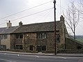
 Laneside Cottage, Farnley.jpg 640 × 524; 63 KB
-
 Lawns House, Chapel Lane, Farnley - geograph.org.uk - 6602071.jpg 1,024 × 768; 134 KB
-

-
 Lawns Park Primary School, Farnley - geograph.org.uk - 4716637.jpg 1,024 × 768; 716 KB
-
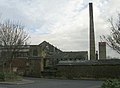 Lodge's Mill - Silver Royd Hill - geograph.org.uk - 622134.jpg 640 × 472; 26 KB
-

-
 Old Toll House (geograph 6114825).jpg 640 × 468; 257 KB
-
 Pump house, Back Lane, Farnley - geograph.org.uk - 2460554.jpg 2,000 × 1,468; 856 KB
-
 Swallow Brick Mills - Tong Road - geograph.org.uk - 631016.jpg 640 × 549; 33 KB
-


_-_geograph.org.uk_-_4715140.jpg)
_-_geograph.org.uk_-_4715144.jpg)


.jpg)


