Category:Buckhout maps of wharves and piers of Manhattan published in 1860
Jump to navigation
Jump to search
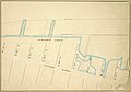
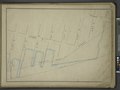
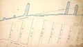
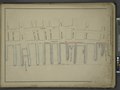
Maps from: Buckhout, I[saac]. C[raig]., surveyor. Maps of the Wharves & Piers from the Battery to 61st Street on the Hudson River and from the Battery to 41st Street on the East River New-York. (New York: 1860), comprising title page and 23 maps. The TIF version of the title page is missing from this category.
Online at The New York Public Library Digital Collections website, Maps of the wharves & piers….
Media in category "Buckhout maps of wharves and piers of Manhattan published in 1860"
The following 48 files are in this category, out of 48 total.
-
 Buckhout Manhattan piers title page publ. 1860.jpg 2,146 × 1,649; 4.1 MB
-
 Buckhout, Manhattan piers, Battery Place to Liberty Street, publ. 1860.jpg 2,515 × 1,772; 4.77 MB
-
 Buckhout, Manhattan piers, Liberty–Warren Street, publ. 1860.jpg 2,509 × 1,766; 4.77 MB
-
 Buckhout, Manhattan piers, Chambers–Laight Street, publ. 1860.jpg 2,501 × 1,755; 4.81 MB
-
 Buckhout, Manhattan piers, Vestry–King Street, publ. 1860.jpg 2,526 × 1,766; 3.18 MB
-
 Buckhout, Manhattan piers, Houston–Charles Street, publ. 1860.jpg 2,510 × 1,755; 3 MB
-
 Buckhout, Manhattan piers, Perry St. to West 12th St., publ. 1860.jpg 2,505 × 1,754; 2.7 MB
-
 Buckhout, Manhattan piers, West 12th–19th St., publ. 1860.jpg 2,504 × 1,753; 2.83 MB
-
 Buckhout, Manhattan piers, West 19th–27th St., publ. 1860.jpg 2,493 × 1,751; 2.81 MB
-
 Buckhout, Manhattan piers, West 28th–36th St., publ. 1860.jpg 2,506 × 1,747; 3.09 MB
-
 Buckhout, Manhattan piers, West 36th–44th St., publ. 1860.jpg 2,497 × 1,758; 2.97 MB
-
 Buckhout, Manhattan piers, West 45th–53rd St., publ. 1860.jpg 2,491 × 1,745; 4.36 MB
-
 Buckhout, Manhattan piers, West 53rd–61st St., publ. 1860.jpg 2,480 × 1,732; 2.71 MB
-
 Buckhout, Manhattan piers, Whitehall Street to Gouverneurs Lane, publ. 1860.jpg 2,499 × 1,758; 4.28 MB
-
 Buckhout, Manhattan piers, Gouverneurs Lane to Peck Slip, publ. 1860.jpg 2,483 × 1,742; 3.49 MB
-
 Buckhout, Manhattan piers, Dover Street to Market Slip, publ. 1860.jpg 2,485 × 1,739; 3.03 MB
-
 Buckhout, Manhattan piers, Pike Slip to Clinton Street, publ. 1860.jpg 2,486 × 1,736; 2.54 MB
-
 Buckhout, Manhattan piers, Montgomery–Corlears Street, publ. 1860.jpg 2,467 × 1,729; 2.58 MB
-
 Buckhout, Manhattan piers, Corlears–Stanton Street, publ. 1860.jpg 2,501 × 1,755; 2.62 MB
-
 Buckhout, Manhattan piers, East Houston–9th Street, publ. 1860.jpg 2,485 × 1,751; 2.65 MB
-
 Buckhout, Manhattan piers, East 10th–17th Street, publ. 1860.jpg 2,497 × 1,750; 2.86 MB
-
 Buckhout, Manhattan piers, East 17th–24th Street, publ. 1860.jpg 2,494 × 1,749; 2.99 MB
-
 Buckhout, Manhattan piers, East 24th–32nd Street, publ. 1860.jpg 2,486 × 1,744; 2.47 MB
-
 Buckhout, Manhattan piers, East 33rd–41st Street, publ. 1860.jpg 2,479 × 1,744; 2.63 MB
-

-
-

-
-

-

-

-

-

-

-

-
-

-

-

-

-

-

-

-

-

-

-

-


