Category:Broomfield, Maidstone
Jump to navigation
Jump to search
village in Maidstone, Kent, United Kingdom  | |||||
| Upload media | |||||
| Instance of | |||||
|---|---|---|---|---|---|
| Location | Broomfield and Kingswood, Maidstone, Kent, South East England, England | ||||
 | |||||
English: Broomfield is a village in the Maidstone District of Kent, England, and forms part of the civil parish of Broomfield and Kingswood. It lies to the east of Maidstone. The village is located just upstream of Leeds Castle on the River Len, one of the tributaries of the River Medway. This Broomfield is not to be confused with Broomfield near Herne Bay, also in Kent.
Subcategories
This category has the following 2 subcategories, out of 2 total.
M
O
- Oasts in Broomfield (2 F)
Media in category "Broomfield, Maidstone"
The following 11 files are in this category, out of 11 total.
-
 Broomfield village sign - geograph.org.uk - 76189.jpg 480 × 640; 89 KB
-
 Church Farmhouse - geograph.org.uk - 1195950.jpg 640 × 481; 81 KB
-
 Farm House on Park Barn Road - geograph.org.uk - 1377347.jpg 640 × 427; 122 KB
-
 Field of peas with water tank, near Broomfield, Kent - geograph.org.uk - 1902274.jpg 1,600 × 1,200; 446 KB
-
 Gate at Crossing with Broomfield Road - geograph.org.uk - 5518758.jpg 4,896 × 3,672; 5.7 MB
-
 Pink Cottage - geograph.org.uk - 1195951.jpg 640 × 481; 114 KB
-
 Roses farmhouse monochrome.jpg 2,448 × 3,264; 1.71 MB
-
 Roses farmhouse.jpg 1,713 × 1,942; 928 KB
-
 St Margaret's Well - geograph.org.uk - 76188.jpg 640 × 480; 166 KB
-
 The A20, near Leeds Castle - geograph.org.uk - 1612752.jpg 640 × 430; 174 KB
-
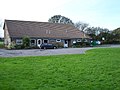 Broomfield and Kingswood village hall - geograph.org.uk - 75689.jpg 640 × 480; 100 KB


