Category:Brooke Road West level crossing
Jump to navigation
Jump to search
| Object location | | View all coordinates using: OpenStreetMap |
|---|
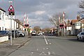
The Northern Line of Merseyrail here constitutes the boundary between Crosby and Brighon-le-Sands.
Media in category "Brooke Road West level crossing"
The following 4 files are in this category, out of 4 total.
-
 Brooke Road West level crossing 1.jpg 4,955 × 3,306; 18.89 MB
-
 Brooke Road West level crossing 2.jpg 5,103 × 3,432; 23.89 MB
-
 View north from Brooke Road West level crossing.jpg 5,198 × 3,462; 24.3 MB
-
 View south from Brooke Road West level crossing.jpg 5,198 × 3,462; 23.25 MB


