Category:Bronnzell
Jump to navigation
Jump to search
| Object location | | View all coordinates using: OpenStreetMap |
|---|
neighborhood in Fulda, Germany  | |||||
| Upload media | |||||
| Instance of | |||||
|---|---|---|---|---|---|
| Location | Fulda, Kassel Government Region, Hesse, Germany | ||||
| Area |
| ||||
| Elevation above sea level |
| ||||
 | |||||
Subcategories
This category has the following 3 subcategories, out of 3 total.
C
S
- Schimmel von Bronnzell (3 F)
Media in category "Bronnzell"
The following 11 files are in this category, out of 11 total.
-
 409 of 'Neue Folge' (11187219485).jpg 3,536 × 3,966; 2.72 MB
-
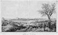 Bronnzell 1850.jpg 450 × 274; 80 KB
-
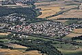 Flug -Nordholz-Hammelburg 2015 by-RaBoe 1081 - Bronnzell.jpg 3,666 × 2,435; 1.86 MB
-
 Flug -Nordholz-Hammelburg 2015 by-RaBoe 1082 - Bronnzell.jpg 3,666 × 2,435; 1.57 MB
-
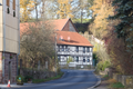
 Fulda Bronnzell Bockmuehl Aesculus Hippocastanum Avenue.png 5,200 × 3,468; 80.87 MB
-
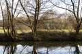 Fulda Ziegel Ziegeler Aue Fliede NR 166410 E a.png 5,200 × 3,468; 87.8 MB
-
 Fulda Ziegel Ziegeler Aue Fliede NR 166410 NE a.png 5,200 × 3,468; 92.35 MB
-
 Fulda Ziegel Ziegeler Str OD.png 5,200 × 3,468; 87.95 MB
-
 Fulda Ziegel Ziegeler Str Pieta f.png 3,228 × 4,788; 87.3 MB
-
 Neubaustrecke Fulda-Bronzell 1987-04-22.jpg 931 × 613; 155 KB
-

.jpg)


