Category:Bromyard Downs
Jump to navigation
Jump to search
English: Bromyard Downs is common land in the civil parish of Norton, in the county of Herefordshire, England.
human settlement in United Kingdom | |||||
| Upload media | |||||
| Instance of | |||||
|---|---|---|---|---|---|
| Location |
| ||||
 | |||||
Media in category "Bromyard Downs"
The following 20 files are in this category, out of 20 total.
-
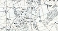 Bromyard Downs Herefordshire OS map SO65NE – Pre1930 to 1954, Pub 1955.jpg 1,663 × 883; 1.08 MB
-
 Bromyard Downs - geograph.org.uk - 113543.jpg 479 × 640; 108 KB
-
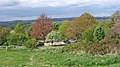
 Bromyard Downs - geograph.org.uk - 569262.jpg 640 × 427; 252 KB
-
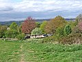
 Bromyard Downs - geograph.org.uk - 830611.jpg 640 × 480; 77 KB
-
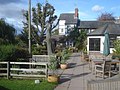
 Bromyard Downs - Park Head house - geograph.org.uk - 830694.jpg 640 × 480; 97 KB
-

-
 Bromyard Downs car park - geograph.org.uk - 1277526 (cropped).jpg 640 × 360; 83 KB
-
 Bromyard Downs car park - geograph.org.uk - 1277526.jpg 640 × 480; 105 KB
-
 Bromyard Downs road top junction - geograph.org.uk - 830683.jpg 640 × 480; 118 KB
-
 Common Decency - geograph.org.uk - 830691.jpg 640 × 480; 110 KB
-
 Cottage on the Bromyard Downs - geograph.org.uk - 2669409.jpg 1,024 × 680; 205 KB
-
 Cottages off Bromyard Downs - geograph.org.uk - 830687.jpg 640 × 480; 102 KB
-
 Methodist Chapel, Bromyard Downs - geograph.org.uk - 569258.jpg 640 × 417; 276 KB
-
 Path to Hillfield Coppice - geograph.org.uk - 1132549.jpg 640 × 480; 107 KB
-
 Patio at the Royal Oak - geograph.org.uk - 1131909.jpg 640 × 480; 97 KB
-
 The Royal Oak - geograph.org.uk - 1131907.jpg 640 × 480; 74 KB
-
 Track across Bromyard Downs - geograph.org.uk - 1132564.jpg 640 × 480; 98 KB
-
 Track across Bromyard Downs - geograph.org.uk - 1132638.jpg 640 × 480; 102 KB
-
 Track from The Foxes - geograph.org.uk - 830702.jpg 640 × 480; 123 KB
-
 View across Bromyard Downs - geograph.org.uk - 1277547.jpg 640 × 480; 90 KB


.jpg)


