Category:Bromley maps of the Bronx published in 1913
Jump to navigation
Jump to search
Maps from: Bromley, George W. and Bromley, Walter S. Atlas of the Borough of the Bronx Annexed District (Philadelphia: G. W. Bromley and Co., 1913), including 45 maps (double-page plates), title page, street index, index to maps or lot subdivisions and obsolete street names, and plate index to this volume (double-page, scanned in two separate images, left and right halves).
Online at The New York Public Library Digital Collections website, Vol. 3 (1913).
Media in category "Bromley maps of the Bronx published in 1913"
The following 50 files are in this category, out of 50 total.
-

-
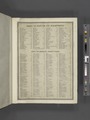
 Street index NYPL2021299.tiff 5,378 × 7,171, 2 pages; 110.39 MB
-
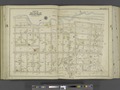
 Index to Maps or Lot Subdivisions NYPL2021296.tiff 5,378 × 7,171, 2 pages; 110.39 MB
-
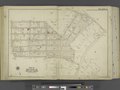
 Index NYPL2021297.tiff 5,398 × 7,197, 2 pages; 111.21 MB
-
 Index continued NYPL2021298.tiff 5,378 × 7,171, 2 pages; 110.39 MB
-
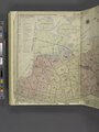
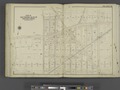
 Bronx, V. 3, Double Page Plate No. 1 (Map bounded by E. 213th St., Lurting Ave., Burke Ave., Bronx River.) NYPL2021300.tiff 7,182 × 5,387, 2 pages; 110.75 MB
-
-
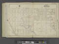
 Bronx, V. 3, Double Page Plate No. 3 (Map bounded by Webster Ave., E. 225th St., Barnes Ave., E. 213th St.) NYPL2021302.tiff 7,020 × 5,265, 2 pages; 105.8 MB
-
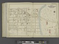
 Bronx, V. 3, Double Page Plate No. 4 (Map bounded by Barnes Ave., E. 233th St., Laconia Ave., E. 219th St.) NYPL2021303.tiff 7,074 × 5,306, 2 pages; 107.44 MB
-
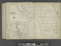
 Bronx, V. 3, Double Page Plate No. 5 (Map bounded by Bronx River, Nereid Ave., Barnes Ave., E. 226th St.) NYPL2021304.tiff 7,150 × 5,362, 2 pages; 109.74 MB
-
 Bronx, V. 3, Double Page Plate No. 6 (Map bounded by Bronx River, 243rd St., Barnes Ave., Nereid Ave.) NYPL2021305.tiff 7,117 × 5,338, 2 pages; 108.75 MB
-
 Bronx, V. 3, Double Page Plate No. 7 (Map bounded by Penfield St., Seton Ave., Pitman Ave., Barnes Ave.) NYPL2021306.tiff 7,079 × 5,309, 2 pages; 107.58 MB
-
 Bronx, V. 3, Double Page Plate No. 8 (Map bounded by Pitman Ave., Seton Ave., Strang Ave., E. 233rd St.) NYPL2021307.tiff 7,135 × 5,352, 2 pages; 109.31 MB
-

-
 Bronx, V. 3, Double Page Plate No. 10 (Map bounded by Dark St., Boston Rd., Eden Terrace, Murdock Ave.) NYPL2021309.tiff 7,091 × 5,318, 2 pages; 107.95 MB
-
 Bronx, V. 3, Double Page Plate No. 11 (Map bounded by Boston Rd., Hutchinson River, Burke Ave., Palmer Ave.) NYPL2021310.tiff 7,175 × 5,382, 2 pages; 110.54 MB
-
 Bronx, V. 3, Double Page Plate No. 12 (Map bounded by Needham Ave., Palmer Ave., Burke Ave., Wilson Ave.) NYPL2021311.tiff 7,044 × 5,283, 2 pages; 106.53 MB
-
 Bronx, V. 3, Double Page Plate No. 13 (Map bounded by Burke Ave., Pelham Bay Park, Bartow Ave., Grace Ave.) NYPL2021312.tiff 7,044 × 5,283, 2 pages; 106.53 MB
-
 Bronx, V. 3, Double Page Plate No. 14 (Map bounded by Grace Ave., Allerton Ave., Eastchester Rd., Burke Ave.) NYPL2021313.tiff 7,096 × 5,322, 2 pages; 108.1 MB
-

-
 Bronx, V. 3, Double Page Plate No. 16 (Map bounded by Burke Ave., Laconia Ave., Allerton Ave., Bronx Park East.) NYPL2021315.tiff 7,166 × 5,374, 2 pages; 110.23 MB
-

-

-

-
 Bronx, V. 3, Double Page Plate No. 20 (Map bounded by Hutchinson River, Pelham Bay Park, Grace Ave., Albany Ave.) NYPL2021319.tiff 7,204 × 5,403, 2 pages; 111.42 MB
-

-

-

-
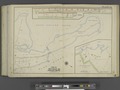
 Bronx, V. 3, Double Page Plate No. 24 (Map bounded by Bear Swamp Rd., Baker Ave., Melville St., Unionport Rd. NYPL2021323.tiff 6,911 × 5,183, 2 pages; 102.54 MB
-

-
 Bronx, V. 3, Double Page Plate No. 26 (Map bounded by West Farms Rd., Castle Hill Ave., McGraw Ave., Beach Ave.) NYPL2021325.tiff 7,200 × 5,400, 2 pages; 111.29 MB
-

-
 Bronx, V. 3, Double Page Plate No. 28 (Map bounded by Sacket Ave., Waters Ave., Westchester Ave., Castle Hill Ave.) NYPL2021327.tiff 7,135 × 5,351, 2 pages; 109.29 MB
-
 Bronx, V. 3, Double Page Plate No. 29 (Map bounded by Morris Park Ave., Eastern Boulevard, Zulette Ave., Waters Ave.) NYPL2021328.tiff 7,187 × 5,390, 2 pages; 110.89 MB
-

-

-

-
 Bronx, V. 3, Double Page Plate No. 33 (Map bounded by E. 174th St., Noble Ave., Watson Ave., Bronx River.) NYPL2021332.tiff 7,203 × 5,403, 2 pages; 111.4 MB
-
 Bronx, V. 3, Double Page Plate No. 34 (Map bounded by Watson Ave., Noble Ave., Lafayette Ave., Bronx River.) NYPL2021333.tiff 7,203 × 5,403, 2 pages; 111.4 MB
-
 Bronx, V. 3, Double Page Plate No. 35 (Map bounded by Watson Ave., Olmstead Ave., Lafayette Ave., Noble Ave.) NYPL2021334.tiff 7,170 × 5,378, 2 pages; 110.38 MB
-
 Bronx, V. 3, Double Page Plate No. 36 (Map bounded by Watson Ave., Seabury Ave., Lafayette Ave., Olmstead Ave.) NYPL2021335.tiff 7,203 × 5,403, 2 pages; 111.4 MB
-

-
-
 Bronx, V. 3, Double Page Plate No. 39 (Map bounded by Lafayette Ave., Westchester Creek, O'Brien Ave, Taylor Ave.) NYPL2021338.tiff 7,207 × 5,405, 2 pages; 111.5 MB
-

-
 Bronx, V. 3, Double Page Plate No. 41 (Map bounded by Long Island Sound, East River, Calhoun Ave., Evans Ave.) NYPL2021340.tiff 7,202 × 5,402, 2 pages; 111.37 MB
-
 Bronx, V. 3, Double Page Plate No. 42 (Map bounded by Fort Schuyler Ave., East River, Seabury Ave., Gridley Ave.) NYPL2021341.tiff 7,160 × 5,370, 2 pages; 110.06 MB
-
 Bronx, V. 3, Double Page Plate No. 43 (Map bounded by Parsons Ave., East River, Westchester Creek.) NYPL2021342.tiff 7,143 × 5,358, 2 pages; 109.55 MB
-
 Bronx, V. 3, Double Page Plate No. 44 (Map bounded by Long Island Sound, Shore Drive, Grover Pl.) NYPL2021343.tiff 7,144 × 5,358, 2 pages; 109.57 MB
-
 Bronx, V. 3, Double Page Plate No. 45 (Map bounded by Long Island Sound, Belden Point, Bridge St.) NYPL2021344.tiff 7,144 × 5,358, 2 pages; 109.57 MB