Category:Brink 14, Deventer
Jump to navigation
Jump to search
| Object location | | View all coordinates using: OpenStreetMap |
|---|
 | |||||
| Upload media | |||||
| Instance of |
| ||||
|---|---|---|---|---|---|
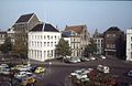
| Location | Deventer, Overijssel, Netherlands | ||||
| Street address |
| ||||
| Heritage designation |
| ||||
 | |||||
|
This is a category about rijksmonument number 12485
|
| Address |
|
Media in category "Brink 14, Deventer"
The following 7 files are in this category, out of 7 total.
-
 Aanzicht - Deventer - 20055592 - RCE.jpg 1,200 × 804; 207 KB
-
 Brink - Deventer - 20053957 - RCE.jpg 1,192 × 1,200; 285 KB
-
 Brink 14 Deventer.jpg 1,712 × 2,560; 1.46 MB
-
 Exterieur OVERZICHT - Deventer - 20261302 - RCE.jpg 1,200 × 778; 151 KB
-
 Exterieur OVERZICHT - Deventer - 20261304 - RCE.jpg 1,200 × 778; 162 KB
-
 Exterieur OVERZICHT VOORGEVELS - Deventer - 20261305 - RCE.jpg 1,200 × 778; 165 KB
-
 Gezicht op de Brink - Deventer - 20055557 - RCE.jpg 1,200 × 875; 185 KB


