Category:Brigidastraat, Bavel
Jump to navigation
Jump to search
| Object location | | View all coordinates using: OpenStreetMap |
|---|
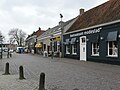
Nederlands: Afbeeldingen van de Brigidastraat in Bavel, behorende tot de gemeente Breda, in de provincie Noord-Brabant in het zuiden van Nederland. Nabij de Heilige Maria Hemelvaartkerk (Bavel). De Brigidastraat is onder meer bereikbaar vanaf de Kerkstraat, de Deken Dr. Dirckxweg en de Kloosterstraat (bron [1])
| NO WIKIDATA ID FOUND! Search for Brigidastraat, Bavel on Wikidata | |
| Upload media |
Subcategories
This category has the following 5 subcategories, out of 5 total.
B
- Bakker Van Kuyk (3 F)
- Bastiaansen Modestad (7 F)
H
K
- Komkommerin (6 F)
S
- Slagerij van Kuijk (3 F)
Media in category "Brigidastraat, Bavel"
The following 4 files are in this category, out of 4 total.
-
 Bavel P1330707.jpg 4,000 × 2,672; 5.79 MB
-
 Brigidastraat Bavel P1330726.jpg 3,977 × 1,405; 1.27 MB
-
 Brigidastraat Bavel P1330737.jpg 4,000 × 2,672; 5.86 MB
-
 P1010874copyBavel.jpg 3,264 × 2,448; 1.97 MB


