Category:Bridle Path (New Zealand)
Jump to navigation
Jump to search
track connecting Christchurch and Lyttelton on the South Island of New Zealand | |||||
| Upload media | |||||
| Instance of | |||||
|---|---|---|---|---|---|
| Location | Christchurch City, Canterbury Region, New Zealand | ||||
 | |||||
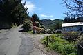
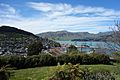
The Bridle Path is a steep track that traverses the northern rim of the Lyttelton volcano connecting the city of Christchurch and the port of Lyttelton in the South Island of New Zealand.
Subcategories
This category has only the following subcategory.
C
Media in category "Bridle Path (New Zealand)"
The following 14 files are in this category, out of 14 total.
-
 071 Bridle Path Christchurch 1967 (51205875897).jpg 3,360 × 2,394; 1.52 MB
-
 Bridle Path 007.jpg 5,472 × 3,648; 8.04 MB
-
 Bridle Path 008.jpg 5,472 × 3,648; 7.08 MB
-
 Bridle Path 009.jpg 3,648 × 5,472; 8.22 MB
-
 Bridle Path 010.jpg 5,472 × 3,648; 5.5 MB
-
 Bridle Path 011.jpg 3,648 × 5,472; 6.11 MB
-
 Bridle Path 012.jpg 5,472 × 3,648; 9.58 MB
-
 Bridle Path 013.jpg 5,472 × 3,648; 8.09 MB
-
 Bridle Path 014.jpg 5,472 × 3,648; 9.54 MB
-
 Bridle Path 015.jpg 5,472 × 3,648; 8.46 MB
-
 Bridle Path 016.jpg 5,472 × 3,648; 8.83 MB
-
 Bridle Path 017.jpg 5,472 × 3,648; 7.36 MB
-
 Bridle Path 018.jpg 5,472 × 3,648; 7.78 MB
-
 Bridle Path 049.JPG 3,264 × 2,448; 3.24 MB
.jpg)


