Category:Bridges in the City of Bradford
Jump to navigation
Jump to search
Subcategories
This category has the following 9 subcategories, out of 9 total.
A
B
I
K
R
S
Media in category "Bridges in the City of Bradford"
The following 39 files are in this category, out of 39 total.
-
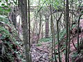 Aqueduct in the woods - geograph.org.uk - 1499393.jpg 640 × 480; 152 KB
-

-
 Bridge and carriageway-1-1000.jpg 1,000 × 750; 193 KB
-
 Bridge by Queensbury Station (2312428475).jpg 2,560 × 1,920; 3.29 MB
-
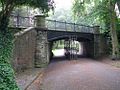
 Bridge ILK 1-22 - Bradford Road, Menston - geograph.org.uk - 924272.jpg 640 × 375; 159 KB
-

-
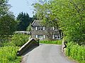
 Bridge over catchwater (1) - geograph.org.uk - 602806.jpg 640 × 480; 93 KB
-
 Bridge over catchwater (2) - geograph.org.uk - 602809.jpg 639 × 479; 64 KB
-
 Bridge over Gill Beck, Esholt (2476288937).jpg 2,560 × 1,920; 5.88 MB
-

-

-
 Bridge over water conduit, Oxenhope - geograph.org.uk - 1238643.jpg 640 × 470; 101 KB
-
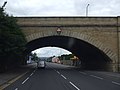
 Bridge TJC3-76B - Station Road - geograph.org.uk - 1513303.jpg 640 × 480; 64 KB
-
 Canal Road Bridge - geograph.org.uk - 1401361.jpg 640 × 480; 48 KB
-

-
 Higher Coach Road - geograph.org.uk - 727177.jpg 640 × 480; 145 KB
-
 Hirst Mill Swing Bridge - geograph.org.uk - 134089.jpg 640 × 480; 67 KB
-
 Hollin Park - geograph.org.uk - 118636.jpg 640 × 425; 111 KB
-
 Horse Close Bridge, North Bierley - geograph.org.uk - 835098.jpg 640 × 480; 141 KB
-
 Horton Park Lake ^ Bridge - geograph.org.uk - 5650346.jpg 1,600 × 1,200; 764 KB
-
 Judy Brig, Judy Woods - geograph.org.uk - 2531929.jpg 1,024 × 768; 226 KB
-
 Loadpit Beck - geograph.org.uk - 727166.jpg 640 × 478; 180 KB
-
 Lodge Hill Bridge, Low Holden - geograph.org.uk - 25248.jpg 640 × 480; 129 KB
-
 Long Bridge, Nr Haworth - geograph.org.uk - 33523.jpg 640 × 480; 148 KB
-
 Maud Bridge, Bingley - geograph.org.uk - 41654.jpg 640 × 480; 175 KB
-

-
 National Cycle Route 66 - geograph.org.uk - 6631604.jpg 1,024 × 684; 244 KB
-
 Old bridge abutment, Station Road, Queensbury (4712757350).jpg 1,798 × 2,487; 6.11 MB
-
 Old bridge, by Queensbury Station (2302011803).jpg 2,523 × 1,682; 3.29 MB
-

-
 Pipe bridge over the River Aire - geograph.org.uk - 1337929.jpg 640 × 480; 109 KB
-
 Queensbury Railway Station - geograph.org.uk - 392556.jpg 640 × 484; 132 KB
-
 Reservoir conduit round Oxenhope Moor - geograph.org.uk - 25529.jpg 640 × 480; 123 KB
-
 Riding Hill Bridge - geograph.org.uk - 386357.jpg 468 × 640; 163 KB
-
 Shipley (34568449776).jpg 6,000 × 4,000; 13.81 MB
-
 Station Road (2676960177).jpg 2,161 × 1,441; 4.4 MB
-

-
 The Boathouse, Saltaire (7243645048).jpg 3,733 × 1,935; 5.22 MB
-
 View from Croft Street bridge. - geograph.org.uk - 744355.jpg 640 × 419; 40 KB


.jpg)


_-_geograph.org.uk_-_602806.jpg)
_-_geograph.org.uk_-_602809.jpg)
.jpg)


.jpg)
.jpg)


.jpg)
.jpg)

.jpg)
