Category:Bridge 40 (Leadbeaters Bridge), Macclesfield Canal
Jump to navigation
Jump to search
| Object location | | View all coordinates using: OpenStreetMap |
|---|
Grade II listed canal bridge in Macclesfield, Cheshire East, Cheshire, England, UK  | |||||
| Upload media | |||||
| Instance of | |||||
|---|---|---|---|---|---|
| Location | Macclesfield, Cheshire East, Cheshire, North West England, England | ||||
| Crosses |
| ||||
| Heritage designation |
| ||||
 | |||||
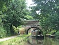
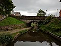
Grade II listed bridge carrying Windmill Lane over the Macclesfield Canal in Macclesfield, Cheshire East. Bridge number 40 on the Macclesfield Canal.
Media in category "Bridge 40 (Leadbeaters Bridge), Macclesfield Canal"
The following 2 files are in this category, out of 2 total.
-
 Macclesfield Canal, Bridge Number 40 At Windmill Lane.jpg 4,160 × 3,120; 3.67 MB
-