Category:Bridge 16, Shropshire Union Canal
Jump to navigation
Jump to search
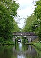
Brick arch farm access bridge over the Shropshire Union Canal (Broomhall Bridge), Brewood and Coven, South Staffordshire, Staffordshire, England.
Bridge 16 over the Shropshire Union Canal.
| Object location | | View all coordinates using: OpenStreetMap |
|---|
canal bridge in Brewood and Coven, South Staffordshire, England, UK  | |||||
| Upload media | |||||
| Instance of | |||||
|---|---|---|---|---|---|
| Location | Brewood and Coven, South Staffordshire, Staffordshire, West Midlands, England | ||||
| Crosses | |||||
| Heritage designation |
| ||||
 | |||||
Media in category "Bridge 16, Shropshire Union Canal"
The following 4 files are in this category, out of 4 total.
-
 Broomhall Bridge - geograph.org.uk - 622027.jpg 640 × 480; 95 KB
-
-

-
 Broomhall Bridge No 16 at Shutt Green - geograph.org.uk - 5750282.jpg 800 × 530; 160 KB


