Category:Brampton, North East Derbyshire
Jump to navigation
Jump to search
civil parish outside Chesterfield, in the North East Derbyshire district, Derbyshire, England  | |||||
| Upload media | |||||
| Instance of | |||||
|---|---|---|---|---|---|
| Named after | |||||
| Location | North East Derbyshire, Derbyshire, East Midlands, England | ||||
| Population |
| ||||
 | |||||
Subcategories
This category has the following 4 subcategories, out of 4 total.
Media in category "Brampton, North East Derbyshire"
The following 200 files are in this category, out of 395 total.
(previous page) (next page)-
 "The Royal Oak", Hollins near Old Brampton - geograph.org.uk - 2934858.jpg 4,155 × 2,770; 2.97 MB
-
 North of Linacre Wood (geograph 5925947).jpg 5,023 × 3,692; 5.52 MB
-
 A pool in the countryside in winter - geograph.org.uk - 1628454.jpg 640 × 480; 95 KB
-
 A scene at Linacre Upper Reservoir - geograph.org.uk - 2313858.jpg 950 × 710; 460 KB
-
 A straight stretch of road - geograph.org.uk - 5803210.jpg 2,000 × 1,333; 1.79 MB
-
 A view of Birley Grange Farm - geograph.org.uk - 5958526.jpg 4,876 × 3,528; 5.11 MB
-
 A619 by East Moor - geograph.org.uk - 3886993.jpg 1,024 × 768; 127 KB
-
 Abandoned toboggans - geograph.org.uk - 1628491.jpg 640 × 479; 81 KB
-
 Access Land on Brampton East Moor - geograph.org.uk - 2931039.jpg 3,202 × 2,340; 1.35 MB
-
 Across the dam, Linacre Middle Reservoir - geograph.org.uk - 2313759.jpg 950 × 597; 349 KB
-
 Across the valley of Sud Brook - geograph.org.uk - 2444129.jpg 950 × 697; 270 KB
-
 Approaching Moorhay Farm - geograph.org.uk - 5289699.jpg 1,600 × 1,200; 484 KB
-
 Approaching Pratthall Farm - geograph.org.uk - 5340789.jpg 1,600 × 1,200; 358 KB
-
 Approaching the ruins on Brampton East Moor - geograph.org.uk - 3774922.jpg 4,858 × 3,886; 5.52 MB
-
 Art and information - geograph.org.uk - 6365600.jpg 480 × 640; 133 KB
-
 Ashgate House Nursing ^ Residential Home - geograph.org.uk - 4753774.jpg 1,280 × 960; 961 KB
-
 Ashgate Road towards Chesterfield - geograph.org.uk - 2441782.jpg 950 × 713; 314 KB
-
 At the Cafe Nostalgia - geograph.org.uk - 2512152.jpg 1,024 × 768; 196 KB
-
 At the ruins on Brampton East Moor - geograph.org.uk - 3774935.jpg 5,184 × 3,888; 5.9 MB
-

-
 B6050 above Blackleach Brook - geograph.org.uk - 3499033.jpg 750 × 563; 138 KB
-
 B6050 below Pratthall - geograph.org.uk - 2444073.jpg 950 × 713; 279 KB
-
 B6050 by Freebirch Farm - geograph.org.uk - 2449482.jpg 950 × 713; 275 KB
-
 B6050 descending towards Cutthorpe - geograph.org.uk - 2314485.jpg 950 × 678; 306 KB
-
 B6050 down to Ingmanthorpe - geograph.org.uk - 2444062.jpg 943 × 690; 292 KB
-
 B6050 heading east - geograph.org.uk - 3999470.jpg 640 × 480; 83 KB
-
 B6050 Layby - geograph.org.uk - 3680360.jpg 800 × 600; 54 KB
-
 B6050 near Barlow Grange - geograph.org.uk - 5609821.jpg 1,800 × 1,350; 490 KB
-
 B6050 near Pratthall - geograph.org.uk - 1282236.jpg 640 × 429; 118 KB
-
 B6050 near Pratthall - geograph.org.uk - 3789698.jpg 1,024 × 735; 180 KB
-
 B6050 towards Baslow - geograph.org.uk - 5057283.jpg 640 × 480; 65 KB
-
 B6050 towards Chesterfield - geograph.org.uk - 3999464.jpg 640 × 480; 55 KB
-
 B6050 towards Chesterfield - geograph.org.uk - 5057288.jpg 640 × 480; 60 KB
-
 B6051 towards Chesterfield - geograph.org.uk - 3999485.jpg 640 × 480; 53 KB
-
 Barn at Loads Head Farm - geograph.org.uk - 1054859.jpg 640 × 480; 91 KB
-
 Barn in a snow covered field - geograph.org.uk - 1628446.jpg 640 × 480; 71 KB
-
 Baslow Road (A619) - geograph.org.uk - 5057273.jpg 640 × 451; 79 KB
-
 Baslow Road Junction - geograph.org.uk - 3680344.jpg 800 × 577; 75 KB
-

-
 Beech trees by Linacre Top Reservoir - geograph.org.uk - 1628570.jpg 640 × 480; 122 KB
-

-
 Beefeater Restaurant - geograph.org.uk - 4066277.jpg 1,000 × 750; 99 KB
-
 Beefeater restaurant and Premier Inn - geograph.org.uk - 4066284.jpg 1,024 × 695; 102 KB
-

-
 Beefeater Restaurant off A619 - geograph.org.uk - 3127879.jpg 2,256 × 1,504; 623 KB
-

-
 Beginning to head downhill - geograph.org.uk - 5803222.jpg 2,000 × 1,317; 1.88 MB
-
 Bendy road on Beeley Moor - geograph.org.uk - 6341502.jpg 6,000 × 4,000; 7.16 MB
-
 Birley Brook - geograph.org.uk - 1284432.jpg 640 × 429; 117 KB
-
 Birley Brook - geograph.org.uk - 2314367.jpg 713 × 950; 505 KB
-
 Birley Brook and hillside - geograph.org.uk - 2314378.jpg 950 × 713; 437 KB
-
 Birley brook. - geograph.org.uk - 6634224.jpg 768 × 1,024; 308 KB
-
 Birley Farm under a grey cloud - geograph.org.uk - 2934805.jpg 4,094 × 3,070; 2.96 MB
-
 Birley Grange Cottage Farm.jpg 800 × 600; 99 KB
-
 Blackleach Brook - geograph.org.uk - 3198684.jpg 4,000 × 3,000; 3.46 MB
-
 Bluebell (closeup), Linacre Reservoirs - geograph.org.uk - 4949915.jpg 480 × 640; 144 KB
-
 Bluebell time in Linacre Wood - geograph.org.uk - 2934759.jpg 4,094 × 3,070; 2.87 MB
-
 Bluebells, Linacre Reservoirs - geograph.org.uk - 4949890.jpg 640 × 480; 259 KB
-
 Boardwalk by Linacre Upper Reservoir - geograph.org.uk - 2314292.jpg 950 × 717; 497 KB
-

-
 Brampton East Moor - geograph.org.uk - 554580.jpg 640 × 430; 163 KB
-
 Brampton parish boundary stone - geograph.org.uk - 2940275.jpg 4,094 × 3,070; 2.95 MB
-
 Bridleway and Hay Bales near Hall Farm - geograph.org.uk - 3198781.jpg 4,000 × 3,000; 2.69 MB
-
 Bridleway Approaching Linacre Wood - geograph.org.uk - 3198741.jpg 4,000 × 3,000; 2.64 MB
-
 Bridleway near Cutthorpe Hall - geograph.org.uk - 3198770.jpg 4,000 × 3,000; 3.16 MB
-
 Bridleway towards Hall Farm - geograph.org.uk - 3856530.jpg 1,600 × 1,200; 846 KB
-

-
 By Flat Farm - geograph.org.uk - 6174044.jpg 2,000 × 1,473; 2.58 MB
-
 By Grange Hill - geograph.org.uk - 6174039.jpg 2,000 × 1,240; 1.08 MB
-
 By Linacre Middle Reservoir - geograph.org.uk - 2313784.jpg 950 × 703; 459 KB
-
 By the edge of Birley Wood - geograph.org.uk - 2314350.jpg 713 × 950; 417 KB
-

-
 By Whitegates Farm - geograph.org.uk - 6174049.jpg 2,000 × 1,436; 1.24 MB
-
 Cairn on Brampton East Moor - geograph.org.uk - 2931053.jpg 3,256 × 2,418; 1.23 MB
-
 Cattle above Birley Brook - geograph.org.uk - 2449431.jpg 851 × 950; 382 KB
-
 Caushouse Farm - the farmhouse - geograph.org.uk - 6378017.jpg 4,648 × 3,602; 3.57 MB
-
 Chesterfield , Barlow Road B6051 - geograph.org.uk - 5952694.jpg 6,000 × 4,000; 6.88 MB
-
 Chesterfield , Dunston Road B6050 - geograph.org.uk - 5952696.jpg 6,000 × 4,000; 6.89 MB
-
 Chesterfield , Newbold Road B6051 - geograph.org.uk - 5952695.jpg 6,000 × 4,000; 7.17 MB
-
 Chesterfield from Longside Moor - geograph.org.uk - 6340877.jpg 6,000 × 4,000; 6.81 MB
-
 Choice of direction - geograph.org.uk - 4502192.jpg 6,000 × 4,000; 4.75 MB
-
 Clodhall - Roadside verge and stone barn - geograph.org.uk - 2959632.jpg 4,132 × 2,952; 2.48 MB
-
 Close up, Elizabeth II postbox on Top Lane, Wadshelf - geograph.org.uk - 5056396.jpg 1,672 × 2,308; 594 KB
-
 Common Lane, Cutthorpe - geograph.org.uk - 3999478.jpg 640 × 480; 61 KB
-
 Communications Mast on Puddingpie Hill - geograph.org.uk - 3127808.jpg 1,504 × 2,256; 660 KB
-
 Concessionary picnic area - geograph.org.uk - 2314427.jpg 950 × 573; 295 KB
-
 Copse in winter - geograph.org.uk - 1628314.jpg 640 × 480; 155 KB
-
 Cottage at Hemming green. - geograph.org.uk - 6634232.jpg 1,024 × 768; 203 KB
-
 Cottages in Hollins - geograph.org.uk - 4462486.jpg 1,280 × 960; 1.07 MB
-
 Country views from Nuttack Lane - geograph.org.uk - 2442235.jpg 950 × 526; 267 KB
-
 Country views near Hare Edge - geograph.org.uk - 3044844.jpg 1,024 × 768; 187 KB
-
 Countryside view from Ashgate Road - geograph.org.uk - 2441791.jpg 950 × 659; 287 KB
-
 Countryside view near Brookside - geograph.org.uk - 2442210.jpg 950 × 713; 310 KB
-

-
 Cricket ground, Cutthorpe - geograph.org.uk - 3999475.jpg 640 × 480; 57 KB
-
 Culvert under Longside Road - geograph.org.uk - 6341506.jpg 6,000 × 4,000; 5.23 MB
-
 Cutthorpe Institute - geograph.org.uk - 3856520.jpg 1,600 × 1,200; 445 KB
-
 Cutthorpe Institute - geograph.org.uk - 3999472.jpg 640 × 480; 72 KB
-
 Cutthorpe Primary School - geograph.org.uk - 6174028.jpg 2,000 × 1,302; 1.56 MB
-

-
 Dalebrook House - geograph.org.uk - 3127892.jpg 2,256 × 1,504; 1.22 MB
-
 Dalebrook House - geograph.org.uk - 4462504.jpg 1,280 × 960; 1.15 MB
-
 Dalebrook House - geograph.org.uk - 5416821.jpg 800 × 533; 157 KB
-
 Dalebrook House and Stonelow Bridge - geograph.org.uk - 3775182.jpg 640 × 427; 59 KB
-

-
 Dam at Lower Linacre Reservoir - geograph.org.uk - 5340787.jpg 1,600 × 1,200; 345 KB
-
 Dam, Linacre Lower Reservoir - geograph.org.uk - 2317197.jpg 726 × 950; 470 KB
-
 Dead tree east of Kitchenflat Wood - geograph.org.uk - 3754138.jpg 4,658 × 3,727; 4.29 MB
-

-
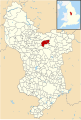 Derbyshire UK parish map highlighting Brampton.svg 888 × 1,308; 2.35 MB
-
 Double bend on Longside Road - geograph.org.uk - 5345751.jpg 800 × 600; 142 KB
-
 Drifts on snow covered fields - geograph.org.uk - 1628443.jpg 640 × 480; 55 KB
-
 Driveway near Dalebrook House - geograph.org.uk - 978037.jpg 640 × 480; 116 KB
-
 Eastbound A619 (Baslow Road) - geograph.org.uk - 4203730.jpg 640 × 480; 266 KB
-
 Edge of Brampton East Moor - geograph.org.uk - 2361927.jpg 640 × 480; 160 KB
-
 Elizabeth II postbox on Top Lane, Wadshelf - geograph.org.uk - 5056391.jpg 3,648 × 2,736; 2.49 MB
-
 Entrance to Loads Head Farm on Syda Lane - geograph.org.uk - 4462441.jpg 1,280 × 960; 1.04 MB
-
 Entrance to Wigley Hall Farm, Wigley - geograph.org.uk - 2934815.jpg 3,856 × 2,892; 4.83 MB
-
 Expanse of moorland on Beeley Moor - geograph.org.uk - 2449605.jpg 950 × 713; 281 KB
-
 Farm at Birley - geograph.org.uk - 2314410.jpg 823 × 950; 481 KB
-
 Farm building, Hare Edge - geograph.org.uk - 5057287.jpg 640 × 480; 100 KB
-

-
 Farm traffic heading towards us - geograph.org.uk - 5803205.jpg 2,000 × 1,333; 2.03 MB
-
 Farmland and woodland - geograph.org.uk - 3999467.jpg 640 × 480; 38 KB
-
 Farmland around Freebirch - geograph.org.uk - 2449488.jpg 950 × 713; 298 KB
-
 Farmland between Hare Edge and Wigley - geograph.org.uk - 2449524.jpg 950 × 713; 321 KB
-
 Farmland north of Ingmanthorpe - geograph.org.uk - 2317165.jpg 950 × 713; 431 KB
-
 Farmland under snow - geograph.org.uk - 1628457.jpg 640 × 480; 122 KB
-
 Farmland, Hare Edge - geograph.org.uk - 5057286.jpg 640 × 480; 56 KB
-
 Field and valley view - geograph.org.uk - 2449454.jpg 950 × 723; 282 KB
-
 Field Barn and Film Location on Clodhall Lane - geograph.org.uk - 4181855.jpg 2,573 × 1,900; 1.08 MB
-
 Field barn at Birley Farm - geograph.org.uk - 5958546.jpg 5,183 × 3,704; 3.65 MB
-
 Field by track from Ducksick Wood - geograph.org.uk - 2441743.jpg 950 × 713; 304 KB
-
 Field east of School Lane. Wadshelf - geograph.org.uk - 5057274.jpg 640 × 480; 68 KB
-
 Field entrance off Syda Lane - geograph.org.uk - 6341487.jpg 6,000 × 4,000; 4.2 MB
-
 Field high above Chesterfield - geograph.org.uk - 2449639.jpg 950 × 713; 263 KB
-

-
 Fields below Ingmanthorpe - geograph.org.uk - 2444101.jpg 950 × 521; 186 KB
-
 Fields by the B6050 - geograph.org.uk - 2449492.jpg 950 × 666; 251 KB
-
 Fields near Rodknoll Farm - geograph.org.uk - 6341470.jpg 6,000 × 4,000; 3.48 MB
-
 Fields northeast of Wigley - geograph.org.uk - 2449424.jpg 950 × 707; 300 KB
-
 Fields sloping below School Lane - geograph.org.uk - 2449546.jpg 950 × 674; 275 KB
-
 Flat Farm and B6050 Road - geograph.org.uk - 2516774.jpg 3,296 × 2,472; 1.07 MB
-
 Foals in a field - geograph.org.uk - 2449417.jpg 950 × 713; 320 KB
-

-
 Footbridge over a small stream in Baines Wood - geograph.org.uk - 3754103.jpg 4,858 × 3,886; 5.73 MB
-
 Footbridge over Birley Brook - geograph.org.uk - 5275174.jpg 1,024 × 768; 330 KB
-
 Footbridge over Sud Brook, south of Newgate - geograph.org.uk - 5341200.jpg 1,600 × 1,200; 320 KB
-
 Footpath behind Fairfield Drive, Holme Hall - geograph.org.uk - 5257254.jpg 1,024 × 768; 219 KB
-
 Footpath between Hollins and Wigley - geograph.org.uk - 2449406.jpg 713 × 950; 300 KB
-

-
 Footpath on the edge of Chesterfield - geograph.org.uk - 4501648.jpg 6,000 × 4,000; 4.29 MB
-
 Footpath to Linacre Road, Holme Hall - geograph.org.uk - 5257256.jpg 1,024 × 768; 191 KB
-
 Footpath to Moorhay Farm - geograph.org.uk - 2596093.jpg 640 × 480; 148 KB
-
 Footpath to Pratthall in Linacre Wood - geograph.org.uk - 5340788.jpg 1,600 × 1,200; 324 KB
-
 Footpath to Salter Wood and Sud Brook - geograph.org.uk - 2444184.jpg 950 × 713; 274 KB
-
 Footpath toward Wadshelf - geograph.org.uk - 2596088.jpg 640 × 480; 138 KB
-
 Footpath towards Cutthorpe Hall - geograph.org.uk - 2441700.jpg 950 × 713; 287 KB
-
 Footpath towards Freebirch - geograph.org.uk - 2596073.jpg 640 × 480; 171 KB
-
 Footpath towards Frith Hall - geograph.org.uk - 2361947.jpg 640 × 480; 148 KB
-
 Footpath towards Wadshelf - geograph.org.uk - 2596083.jpg 640 × 480; 163 KB
-
 Footpath, Linacre Wood - geograph.org.uk - 2313744.jpg 950 × 707; 485 KB
-
 Ford on the byway between Barlow and Cutthorpe - geograph.org.uk - 3856515.jpg 1,600 × 1,200; 961 KB
-
 Foxglove glory - geograph.org.uk - 5825603.jpg 3,456 × 5,184; 2.4 MB
-
 Freebirch Farm - geograph.org.uk - 5289706.jpg 1,600 × 1,200; 461 KB
-
 Frith Hall Farmhouse.jpg 4,800 × 3,314; 3.67 MB
-
 Game Lea Farm - Car Park - geograph.org.uk - 1471712.jpg 640 × 480; 85 KB
-
 Gateway looking towards Ingmanthorpe - geograph.org.uk - 1282437.jpg 640 × 429; 92 KB
-
 Gorse bushes flowering near Birley - geograph.org.uk - 1284394.jpg 640 × 429; 115 KB
-
 Gorse flowering by the Birley Brook - geograph.org.uk - 1284360.jpg 640 × 429; 101 KB
-

-
 Grange House Farm - geograph.org.uk - 3754131.jpg 5,073 × 3,805; 4.46 MB
-
 Grasses on the wire - geograph.org.uk - 1628459.jpg 640 × 432; 90 KB
-
 Grassland and woodland - geograph.org.uk - 2319104.jpg 950 × 713; 378 KB
-
 Grazing and woodland near Frith Hall - geograph.org.uk - 2449382.jpg 677 × 950; 314 KB
-
 Grazing towards Pratthall - geograph.org.uk - 3999459.jpg 640 × 480; 64 KB
-
 Grazing, Puddingpie Hill - geograph.org.uk - 5057280.jpg 640 × 403; 49 KB
-
 Guide Post near Cornerstone Farm.jpg 2,472 × 3,296; 1,021 KB
-
 Hamlet of Ingmanthorpe - geograph.org.uk - 2444085.jpg 950 × 529; 229 KB
-
 Harrowing time on Cutthorpe Common - geograph.org.uk - 5926073.jpg 5,111 × 3,390; 4.72 MB
-
 Head of a sheep near Jumble Hole - geograph.org.uk - 5925928.jpg 4,790 × 3,678; 2.89 MB
-
 Hemming Green - geograph.org.uk - 1628643.jpg 640 × 480; 83 KB
-
 Herb-Robert, Linacre Reservoirs - geograph.org.uk - 4953040.jpg 640 × 480; 97 KB
-
 Hipper Sick - geograph.org.uk - 5289437.jpg 1,600 × 1,200; 674 KB
-

-
 In Birley Wood - view of Birley Brook - geograph.org.uk - 2934791.jpg 3,070 × 4,094; 2.99 MB
-
 In need of repair - geograph.org.uk - 3371874.jpg 800 × 579; 122 KB
-
 In Old Brampton - view to the parish church - geograph.org.uk - 2935021.jpg 2,849 × 4,273; 2.84 MB
-
 Inflow into Linacre Middle Reservoir - geograph.org.uk - 2313795.jpg 950 × 713; 463 KB
-

-
 Inscribed Stone at Bagthorpe Farm - geograph.org.uk - 2931032.jpg 3,296 × 2,472; 1.1 MB
-
 Inscribed Stone near Hipper Sick - geograph.org.uk - 2476402.jpg 2,464 × 3,296; 1.16 MB
-
 Junction of Bradshaw Lane with A619 - geograph.org.uk - 3125896.jpg 2,256 × 1,504; 916 KB
-

-
 Kitchenflat Wood view - geograph.org.uk - 5500008.jpg 2,592 × 1,944; 1.38 MB
-
 Lane junction by Wigley School - geograph.org.uk - 2449539.jpg 950 × 763; 320 KB
-
 Lane junction with Top Lane to the right - geograph.org.uk - 2449532.jpg 950 × 646; 277 KB
-
 Lane to Wigley Farm - geograph.org.uk - 2449541.jpg 950 × 672; 300 KB
-
 Lane up to Old Brampton - geograph.org.uk - 1628607.jpg 640 × 480; 68 KB
-
 Large barn at Flat Farm, Freebirch - geograph.org.uk - 5289709.jpg 1,600 × 1,200; 505 KB

.jpg)


_-_geograph.org.uk_-_5057273.jpg)


,_Linacre_Reservoirs_-_geograph.org.uk_-_4949915.jpg)


_-_geograph.org.uk_-_4203730.jpg)


