Category:Brafferton and Helperby
Jump to navigation
Jump to search
English: Brafferton and Helperby is a civil parish in the Hambleton district, in the county of North Yorkshire, England.
civil parish in Hambleton, North Yorkshire, England | |||||
| Upload media | |||||
| Instance of | |||||
|---|---|---|---|---|---|
| Location | Hambleton, North Yorkshire, Yorkshire and the Humber, England | ||||
| Population |
| ||||
 | |||||
Subcategories
This category has the following 3 subcategories, out of 3 total.
B
H
T
Media in category "Brafferton and Helperby"
The following 191 files are in this category, out of 191 total.
-
 'Pilmoor Junction', Pilmoor Cottages - geograph.org.uk - 5890339.jpg 1,024 × 768; 225 KB
-
 7 - 10 Pilmoor Cottages (west side) - geograph.org.uk - 5890367.jpg 1,024 × 768; 188 KB
-
 A farmhouse near Brafferton - geograph.org.uk - 3018353.jpg 800 × 600; 90 KB
-
 A Hidden World - geograph.org.uk - 5374365.jpg 4,000 × 3,000; 2.81 MB
-
 A minor road to Sessay - geograph.org.uk - 4278084.jpg 1,024 × 768; 112 KB
-
 A track into The Avenue - geograph.org.uk - 2193448.jpg 640 × 480; 211 KB
-
 Access Lane from New Mills - geograph.org.uk - 4845128.jpg 1,600 × 1,067; 545 KB
-
 Across West Moor to East Moor copse - geograph.org.uk - 2408042.jpg 1,152 × 864; 503 KB
-
 Agricultural building at Pilmoor Hall - geograph.org.uk - 4278109.jpg 1,024 × 768; 166 KB
-
 Along Jobbing Cross - geograph.org.uk - 2193481.jpg 640 × 480; 206 KB
-
 Approaching Helperby - geograph.org.uk - 4595084.jpg 1,600 × 1,067; 625 KB
-
 Approaching Oak Tree Farm from the northwest - geograph.org.uk - 6213118.jpg 1,600 × 1,200; 653 KB
-
 Back Lane, Helperby - geograph.org.uk - 4594090.jpg 1,600 × 1,067; 601 KB
-
 Bare field at Ray Banks - geograph.org.uk - 5890114.jpg 1,024 × 768; 236 KB
-
 Beside the Woods on East Moor - geograph.org.uk - 4845994.jpg 1,600 × 1,067; 656 KB
-
 Brafferton Bridge - geograph.org.uk - 4594050.jpg 1,600 × 1,067; 695 KB
-
 Brafferton Manor - geograph.org.uk - 4849826.jpg 1,600 × 1,067; 603 KB
-
 Brecks Lane - geograph.org.uk - 6437063.jpg 3,888 × 5,184; 6.81 MB
-
 Bridleway between Brafferton and The River Swale - geograph.org.uk - 4595199.jpg 1,600 × 1,067; 707 KB
-

-
 Buskey Closes - geograph.org.uk - 5890169.jpg 1,024 × 768; 221 KB
-
 Course of railway - geograph.org.uk - 2193441.jpg 640 × 480; 263 KB
-
 Cyclists on the Thornton Bridge Road - geograph.org.uk - 4941505.jpg 640 × 427; 108 KB
-
 Danger, lorries turning at Jobbing Cross - geograph.org.uk - 4278012.jpg 1,024 × 768; 252 KB
-
 Descending Coneygarth Hill - geograph.org.uk - 5818882.jpg 5,184 × 3,456; 6.78 MB
-
 Dismantled railway near Brafferton - geograph.org.uk - 2898486.jpg 640 × 480; 87 KB
-
 Disused railway bridge over River Swale - geograph.org.uk - 5556602.jpg 5,152 × 3,864; 7.08 MB
-
 Drainage ditch near The Birches - geograph.org.uk - 2898497.jpg 640 × 480; 134 KB
-
 Electricity pole at Spring House Farm - geograph.org.uk - 4278425.jpg 1,024 × 768; 126 KB
-
 Entering Brafferton Helperby - geograph.org.uk - 3018355.jpg 800 × 600; 119 KB
-
 Entering Brafferton Spring Wood - geograph.org.uk - 4849801.jpg 1,600 × 1,067; 671 KB
-
 Entrance to Pilmoor Hall - geograph.org.uk - 2193450.jpg 640 × 480; 314 KB
-
 Ewe Hole Lane (track) - geograph.org.uk - 2898477.jpg 640 × 480; 66 KB
-
 Ewe Hole Lane (track) heading north - geograph.org.uk - 2898493.jpg 640 × 480; 73 KB
-
 Ewe Hole Lane - geograph.org.uk - 5844047.jpg 1,600 × 1,200; 807 KB
-
 Ewe Hole Lane - geograph.org.uk - 5844058.jpg 1,600 × 1,200; 556 KB
-
 Ewe Hole Lane - geograph.org.uk - 6437054.jpg 5,184 × 3,888; 6.41 MB
-
 Ewe Hole Lane - geograph.org.uk - 6437061.jpg 5,184 × 3,888; 6.77 MB
-
 Ewe with lambs - geograph.org.uk - 6437044.jpg 5,169 × 3,726; 5.45 MB
-
 Farm track off Pasture Lane - geograph.org.uk - 2898519.jpg 640 × 480; 110 KB
-
 Farmland near Low Wood - geograph.org.uk - 2670111.jpg 800 × 599; 53 KB
-
 Farmland near Raskelf Road - geograph.org.uk - 2193525.jpg 640 × 480; 227 KB
-
 Farmland near Spring House Farm - geograph.org.uk - 2898476.jpg 640 × 480; 46 KB
-
 Farmland near Spring House Farm - geograph.org.uk - 2898478.jpg 640 × 480; 73 KB
-
 Farmland off Pasture Lane - geograph.org.uk - 2898522.jpg 640 × 480; 61 KB
-
 Farmland on the east side of Jobbing Cross - geograph.org.uk - 5890136.jpg 1,024 × 768; 260 KB
-
 Farmland on the north side of Jobbing Cross - geograph.org.uk - 5890151.jpg 1,024 × 768; 237 KB
-
 Farmland towards The Avenue - geograph.org.uk - 2898483.jpg 640 × 480; 47 KB
-
 Farmland west of Springfield Farm - geograph.org.uk - 5890156.jpg 1,024 × 768; 206 KB
-
 Farmland, Cottage Pasture - geograph.org.uk - 2898513.jpg 640 × 480; 88 KB
-
 Farmland, Moor End Field - geograph.org.uk - 2898526.jpg 640 × 480; 53 KB
-
 Fawdington Road - geograph.org.uk - 5763716.jpg 640 × 427; 235 KB
-
 Field access track at Mill Field, Helperby - geograph.org.uk - 5844064.jpg 1,600 × 1,200; 915 KB
-
 Field beside High Lane - geograph.org.uk - 5818904.jpg 5,184 × 3,456; 6.73 MB
-
 Field beside Moor Lane - geograph.org.uk - 5818095.jpg 5,184 × 3,456; 6.95 MB
-
 Field by Parks Plantation - geograph.org.uk - 4849789.jpg 1,600 × 1,067; 507 KB
-
 Field entrance near The Birches - geograph.org.uk - 2898494.jpg 640 × 480; 58 KB
-
 Field on Coneygarth Hill - geograph.org.uk - 5818898.jpg 5,184 × 3,456; 7.15 MB
-
 Field outside Helperby - geograph.org.uk - 4595089.jpg 1,600 × 1,067; 586 KB
-
 Footbridge over the River Swale, Brafferton - geograph.org.uk - 2958787.jpg 1,463 × 1,951; 1.8 MB
-
 Footpath beside the River Swale - geograph.org.uk - 2898447.jpg 640 × 480; 92 KB
-
 From West Moor copse towards Pilmoor Hall farm - geograph.org.uk - 2406403.jpg 1,152 × 864; 551 KB
-
 Garden railway bridge, Pilmoor Cottages - geograph.org.uk - 5890389.jpg 1,024 × 768; 288 KB
-

-
 Gates into woodland, Jobbing Cross - geograph.org.uk - 4278025.jpg 1,024 × 768; 280 KB
-

-
 Hedgerow in the rain - geograph.org.uk - 2193487.jpg 640 × 480; 241 KB
-
 Helperby - geograph.org.uk - 4594040.jpg 1,600 × 1,067; 579 KB
-
 High Lane toward Helperby - geograph.org.uk - 5556527.jpg 1,024 × 768; 604 KB
-
 High water at Thornton Bridge - geograph.org.uk - 6748578.jpg 3,691 × 4,923; 2.88 MB
-
 Horse sheltering under a tree - geograph.org.uk - 2193520.jpg 640 × 480; 225 KB
-
 In Helperby - geograph.org.uk - 4594067.jpg 1,600 × 1,067; 530 KB
-
 In the woods on East Moor - geograph.org.uk - 4846020.jpg 1,600 × 1,067; 807 KB
-
 Jobbing Cross - geograph.org.uk - 4278018.jpg 1,024 × 768; 234 KB
-
 Jobbing Cross Bridge - geograph.org.uk - 4846010.jpg 1,600 × 1,067; 577 KB
-
 Jobbing Cross Bridge - geograph.org.uk - 6213033.jpg 1,600 × 1,200; 688 KB
-
 Lane to Pilmoor Cottages - geograph.org.uk - 2193417.jpg 640 × 480; 241 KB
-
 Lane to Thorny Field north of Pilmoor House - geograph.org.uk - 5844045.jpg 1,600 × 1,200; 650 KB
-
 Lane toward Helperby - geograph.org.uk - 5556524.jpg 1,024 × 768; 560 KB
-
 Line of former Pilmoor Tile and Brick Works tramway - geograph.org.uk - 5374351.jpg 4,000 × 3,000; 4.85 MB
-
 Line of former railway track - geograph.org.uk - 6437058.jpg 5,184 × 3,888; 4.24 MB
-
 Line of the dismantled railway north of Brafferton - geograph.org.uk - 5844072.jpg 1,600 × 1,200; 703 KB
-
 Little used footpath alongside River Swale - geograph.org.uk - 5556618.jpg 5,152 × 3,864; 6.98 MB
-
 Long shadows from the hedge along Ewe Hole Lane - geograph.org.uk - 4278455.jpg 1,024 × 768; 159 KB
-
 Looking South along Main Street, Helperby - geograph.org.uk - 4594028.jpg 1,600 × 1,067; 527 KB
-
 Looking west towards Brafferton - geograph.org.uk - 3018351.jpg 800 × 600; 139 KB
-
 Low Wood - geograph.org.uk - 2193405.jpg 640 × 480; 273 KB
-
 Lych Gate, St. Peters Church, Brafferton - geograph.org.uk - 2958772.jpg 1,112 × 1,483; 879 KB
-
 Main Street - geograph.org.uk - 5763712.jpg 640 × 427; 231 KB
-
 Main Street Helperby - geograph.org.uk - 5556529.jpg 1,024 × 768; 362 KB
-
 Main Street Helperby - geograph.org.uk - 5556530.jpg 1,024 × 768; 459 KB
-
 Main Street Helperby - geograph.org.uk - 6437083.jpg 4,975 × 3,205; 3.72 MB
-
 Main Street, Helperby - geograph.org.uk - 4593901.jpg 1,600 × 1,067; 547 KB
-
 Minor road towards Flawith - geograph.org.uk - 2898508.jpg 640 × 480; 109 KB
-
 Minor road towards Flawith - geograph.org.uk - 2898529.jpg 640 × 480; 106 KB
-
 Minor road towards Raskelf - geograph.org.uk - 2898499.jpg 640 × 480; 56 KB
-
 Minor road towards Sessay - geograph.org.uk - 2898479.jpg 640 × 480; 52 KB
-
 Minor road towards Sessay - geograph.org.uk - 2898484.jpg 640 × 480; 38 KB
-
 Oak Tree Farm - geograph.org.uk - 2193399.jpg 640 × 480; 254 KB
-
 Oak Tree Farm from the railway - geograph.org.uk - 4601613.jpg 1,600 × 747; 133 KB
-
 On Moor Lane - geograph.org.uk - 5818018.jpg 5,184 × 3,456; 7.72 MB
-
 One of a kind at Jobbing Cross - geograph.org.uk - 4278033.jpg 768 × 1,024; 539 KB
-
 Outbuildings attached to Oak Tree Farm - geograph.org.uk - 4846707.jpg 1,600 × 1,067; 616 KB
-
 Partly waterlogged field, east of Ewe Hole Lane - geograph.org.uk - 4278466.jpg 1,024 × 768; 180 KB
-
 Pasture Lane towards Mount Pleasant - geograph.org.uk - 2898516.jpg 640 × 480; 123 KB
-
 Pasture Lane towards Mount Pleasant - geograph.org.uk - 2898523.jpg 640 × 480; 125 KB
-
 Pasture, Brecks - geograph.org.uk - 2898492.jpg 640 × 480; 71 KB
-
 Pilmoor Cottages and the East Coast Main Line - geograph.org.uk - 6090951.jpg 1,600 × 1,200; 740 KB
-
 Ploughed field off Pasture Lane - geograph.org.uk - 2898520.jpg 640 × 480; 69 KB
-
 Pond and grazing, Austin's Hill - geograph.org.uk - 2898490.jpg 640 × 480; 66 KB
-
 Pond at Brafferton - geograph.org.uk - 6437089.jpg 5,184 × 3,888; 7.23 MB
-
-
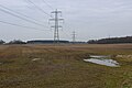
 Power lines crossing waterlogged farmland - geograph.org.uk - 4278099.jpg 1,024 × 768; 126 KB
-
 Private road to Pilmoor Grange - geograph.org.uk - 4278044.jpg 1,024 × 768; 211 KB
-
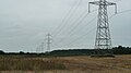
 Pylons across the plain - geograph.org.uk - 2570331.jpg 2,108 × 2,176; 897 KB
-
 Pylons near the Fawdington Junction - geograph.org.uk - 2193478.jpg 640 × 480; 193 KB
-
 Pylons over a field of stubble - geograph.org.uk - 2193444.jpg 640 × 480; 219 KB
-
 Pylons over Pilmoor - geograph.org.uk - 4845984.jpg 1,600 × 1,067; 337 KB
-
 Raghill Lane - geograph.org.uk - 6437068.jpg 3,601 × 4,546; 4.59 MB
-
 Raghill Lane approaching a Brick Wall - geograph.org.uk - 5818109.jpg 5,184 × 3,456; 7.15 MB
-
 Raghill Lane looking East - geograph.org.uk - 5817932.jpg 5,184 × 3,456; 4.75 MB
-
 Raghill Lane looking West - geograph.org.uk - 5817941.jpg 5,184 × 3,456; 7.5 MB
-
 Raghill Lane towards Helperby Moor - geograph.org.uk - 5844736.jpg 1,600 × 1,200; 870 KB
-
 Rape and horse chestnuts - geograph.org.uk - 5763695.jpg 640 × 427; 263 KB
-
 Rape fields near Raybank - geograph.org.uk - 5763715.jpg 640 × 427; 241 KB
-
 Rape off High Lane - geograph.org.uk - 5763697.jpg 640 × 427; 246 KB
-
 Raskelf Road - geograph.org.uk - 4849818.jpg 1,600 × 1,067; 443 KB
-
 Raskelf Road - geograph.org.uk - 4941503.jpg 640 × 427; 84 KB
-
 Raskelf Road - geograph.org.uk - 5390152.jpg 427 × 640; 244 KB
-
 Raskelf Road - geograph.org.uk - 6151680.jpg 1,024 × 768; 701 KB
-
 River Swale at The Holmes - geograph.org.uk - 4593750.jpg 1,600 × 1,067; 592 KB
-
 River Swale from footbridge, Brafferton - geograph.org.uk - 2958782.jpg 2,000 × 1,500; 1.72 MB
-
 River Swale's eastern floodbank - geograph.org.uk - 4278519.jpg 1,024 × 768; 126 KB
-
 Road alongside Spring House Farm (1) - geograph.org.uk - 4278121.jpg 1,024 × 768; 122 KB
-
 Road alongside Spring House Farm (2) - geograph.org.uk - 4278130.jpg 1,024 × 768; 120 KB
-
 Road Closed to Thornton Bridge - geograph.org.uk - 4845021.jpg 1,600 × 1,067; 259 KB
-
 Road to Brafferton in the rain - geograph.org.uk - 2193516.jpg 640 × 480; 187 KB
-
 Road to Sessay at East Moor - geograph.org.uk - 6213031.jpg 1,600 × 1,200; 730 KB
-
 School playing field, Brafferton - geograph.org.uk - 6437085.jpg 5,131 × 3,315; 3.67 MB
-
 Sheep pasture, Brafferton - geograph.org.uk - 6437048.jpg 5,184 × 3,888; 6.25 MB
-
 Sheep sheltering under trees at Springfield Farm - geograph.org.uk - 5890152.jpg 1,024 × 576; 127 KB
-
 Silver birch alongside the road at East Moor - geograph.org.uk - 4278061.jpg 1,024 × 768; 177 KB
-
 Spring House Farm - geograph.org.uk - 2898481.jpg 640 × 480; 53 KB
-
 Springfield or Spring House Farm - geograph.org.uk - 5890157.jpg 1,024 × 768; 235 KB
-
 St Peter's Parish Church Brafferton - geograph.org.uk - 5556536.jpg 1,024 × 754; 441 KB
-
 St Peter, Brafferton - East end - geograph.org.uk - 5661812.jpg 900 × 684; 277 KB
-
 St Peter, Brafferton - geograph.org.uk - 5661808.jpg 900 × 692; 297 KB
-
 St Peter, Brafferton - geograph.org.uk - 5661810.jpg 900 × 682; 462 KB
-
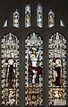
 St Peter, Brafferton - Pulpit - geograph.org.uk - 5661819.jpg 688 × 900; 266 KB
-

-

-
-

-
 St. Peter's Church, Brafferton - geograph.org.uk - 4595198.jpg 1,600 × 1,067; 641 KB
-
 St. Peter's School - geograph.org.uk - 5763713.jpg 640 × 427; 246 KB
-

-
 Stubble and Wood - geograph.org.uk - 132866.jpg 640 × 425; 71 KB
-
 Summer trees near Ewe Hole Lane - geograph.org.uk - 5890134.jpg 1,024 × 768; 261 KB
-
 The Avenue, near Pilmoor Hall - geograph.org.uk - 5890166.jpg 1,024 × 768; 238 KB
-
 The corner of West Moor copse - geograph.org.uk - 2403661.jpg 2,560 × 1,920; 3.33 MB
-
 The edge of woodland at East Moor - geograph.org.uk - 4278090.jpg 1,024 × 768; 170 KB
-
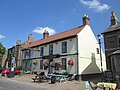 The Golden Lion, Helperby - geograph.org.uk - 5844070.jpg 1,600 × 1,200; 558 KB
-
 The newer of two tracks into The Avenue - geograph.org.uk - 5890163.jpg 1,024 × 768; 290 KB
-
 The road between Ox Closes and Ray Banks - geograph.org.uk - 4278445.jpg 1,024 × 768; 163 KB
-
 The road from Thornton Bridge to Brafferton - geograph.org.uk - 5887890.jpg 1,024 × 768; 168 KB
-
 The road to Pilmoor - geograph.org.uk - 4278473.jpg 1,024 × 768; 162 KB
-
 The Sessay to Brafferton road - geograph.org.uk - 2570313.jpg 3,264 × 2,448; 2.14 MB
-
 The shadow of a barn, Spring House Farm - geograph.org.uk - 4278435.jpg 1,024 × 615; 137 KB
-
 The shadow of a gable end, Spring House Farm - geograph.org.uk - 4278431.jpg 1,024 × 768; 177 KB
-
 The shadow of a roof-line, Spring House Farm - geograph.org.uk - 4278432.jpg 1,024 × 614; 141 KB
-
 The way to Myton-on-Swale - geograph.org.uk - 3018732.jpg 800 × 600; 163 KB
-
 Towards East Moor from West Moor - geograph.org.uk - 4845121.jpg 1,600 × 1,067; 639 KB
-
 Towards Pilmoor Cottages - geograph.org.uk - 2193412.jpg 640 × 469; 234 KB
-
 Towards Spring House Farm - geograph.org.uk - 2193461.jpg 640 × 480; 215 KB
-
 Track alongside Myton Far End Plantation - geograph.org.uk - 5556521.jpg 1,024 × 768; 763 KB
-
 Track to Austin's Hill - geograph.org.uk - 2898489.jpg 640 × 480; 113 KB
-
 Train passes under Race Lane - geograph.org.uk - 2193428.jpg 640 × 480; 281 KB
-
 Tree alongside a drain, Ox Closes - geograph.org.uk - 4278481.jpg 1,024 × 768; 191 KB
-
 Tree on Ewe Hole Lane - geograph.org.uk - 5890122.jpg 1,024 × 768; 203 KB
-
 Trees along field boundary - geograph.org.uk - 6437053.jpg 3,655 × 4,627; 5.49 MB
-
 Trees on farmland south of Raybanks - geograph.org.uk - 4278496.jpg 1,024 × 768; 121 KB
-
 Verge of daffodils and dandelions - geograph.org.uk - 5763709.jpg 640 × 427; 267 KB
-
 View towards Brafferton Spring Wood - geograph.org.uk - 4845132.jpg 1,600 × 1,067; 667 KB
-
 View towards Churchill Plantation - geograph.org.uk - 4595092.jpg 1,600 × 1,067; 639 KB
-
 Village Pump Helperby - geograph.org.uk - 5556532.jpg 768 × 1,024; 344 KB
-
 Walled boundary of Helperby Hall - geograph.org.uk - 5763711.jpg 640 × 427; 295 KB
-

-

-
 Wetland in Mickland Field - geograph.org.uk - 5763707.jpg 640 × 427; 227 KB
-
 Winter trees along Ewe Hole Lane - geograph.org.uk - 4278453.jpg 1,024 × 768; 171 KB
-
 Woodland path - geograph.org.uk - 6437079.jpg 3,249 × 4,575; 4.62 MB

_-_geograph.org.uk_-_5890367.jpg)


_-_geograph.org.uk_-_2898477.jpg)
_heading_north_-_geograph.org.uk_-_2898493.jpg)


_-_geograph.org.uk_-_4278121.jpg)
_-_geograph.org.uk_-_4278130.jpg)


