Category:Bradley Point
Jump to navigation
Jump to search

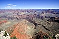
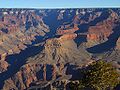
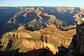
Sumner Butte-(left), Bradley Point-(center), Demaray Point-(right)
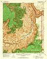
English: Bradley Point (west), and Demaray Point (east) are the 2 lower-elevation ridgeline points overlooking Granite Gorge, that are part of the base of Zoroaster Temple-(Zoroaster Canyon is on east perimeter, adjacent to Clear Creek (Arizona)); a 3rd butte, Sumner Butte is separated to the west, and is at the southeast perimeter of Bright Angel Canyon, (Creek) as it enters down the fault (Bright Angel Fault), down into Granite Gorge-(the region called The Box, because of its geography-(the faults intersection), and also its geology). Sumner Butte and the fault is also at the intersection of the Grandview - Bright Angel Fault.
The en:Clear Creek Trail traverses the base of Bradley Point, on the Tonto Platform, then goes up Zoroaster Canyon to terminate at a middle section of Clear Creek.
The en:Clear Creek Trail traverses the base of Bradley Point, on the Tonto Platform, then goes up Zoroaster Canyon to terminate at a middle section of Clear Creek.
Subcategories
This category has the following 2 subcategories, out of 2 total.
B
- Bradley Point closeup (5 F)
C
Media in category "Bradley Point"
The following 28 files are in this category, out of 28 total.
-
 0059 Grand Canyon Mather Point Improvements (5373762649).jpg 4,293 × 2,976; 2.24 MB
-
 1 Grandcanyon2 panoram 2010.jpg 6,285 × 2,336; 9.7 MB
-
 Arizona. LOC 99446124-2.jpg 6,471 × 8,018; 12.08 MB
-
 Arizona. LOC 99446126-11.jpg 4,883 × 6,157; 6.27 MB
-
 Arizona. LOC 99446126-2.jpg 5,014 × 6,252; 6.24 MB
-
 GC HDR 2 Yavapai Point.jpg 4,237 × 2,740; 7.17 MB
-
 Grand Canyon (1).jpg 3,000 × 2,000; 2.64 MB
-
 Grand Canyon (26374424110).jpg 4,608 × 3,456; 2.77 MB
-
 Grand Canyon (Grand Canyon National Park Service).jpg 3,691 × 1,945; 3.51 MB
-
 Grand Canyon 09 2017 5087.jpg 5,297 × 1,200; 6.29 MB
-
 Grand Canyon 20060612.jpg 3,504 × 2,336; 2.85 MB
-
 Grand Canyon du Colorado Arizona (USA).jpg 4,895 × 2,151; 2.06 MB
-
 Grand Canyon in Arizona - 2008-04-07 A.jpg 2,959 × 1,973; 5.83 MB
-
 Grand Canyon Mather Point01.jpg 1,680 × 2,520; 2.8 MB
-
 Grand Canyon national park 1.jpg 4,032 × 3,024; 3.35 MB
-
 Grand Canyon National Park, Sunset from Yaki Point 5207 - Flickr - Grand Canyon NPS.jpg 4,421 × 2,871; 4.66 MB
-
 Grand Canyon Powell Point Evening Light 2013.jpg 4,611 × 2,162; 4.08 MB
-
 Grand Canyon South Rim 4.JPG 1,600 × 1,200; 402 KB
-
 Grand Canyon-Mather point.jpg 1,024 × 768; 136 KB
-
 Grand Caynon South Rim 08 2010 9988.jpg 2,400 × 1,600; 3.84 MB
-
 Grandcanyon view3.jpg 2,048 × 1,536; 664 KB
-
 Grandcanyon view5.jpg 1,969 × 1,410; 579 KB
-
 Grandview-Phantom Monocline.jpg 1,013 × 587; 171 KB
-
 Harvey Butchart's hiking map - Flickr - brewbooks (8).jpg 3,264 × 2,448; 3.73 MB
-
 Las Vegas G3 Pic - 153.jpg 1,704 × 2,272; 1.12 MB
-
 Plateau Point in Grand Canyon National Park.jpg 4,032 × 3,024; 4.08 MB
-
 View of Grand Canyon from Kaibab trail.jpg 3,840 × 2,391; 4.21 MB
-

.jpg)


.jpg)
.jpg)
.jpg)

.jpg)


.jpg)


