Category:Boundary stones between Prussia and Saxony - 69 (linkselbisch)
Jump to navigation
Jump to search
 | |||||
| Upload media | |||||
| Instance of | |||||
|---|---|---|---|---|---|
| Part of |
| ||||
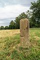
| Location | Elstertrebnitz, Landkreis Leipzig, Saxony, Germany | ||||
| Heritage designation | |||||
| Inception |
| ||||
 | |||||
Media in category "Boundary stones between Prussia and Saxony - 69 (linkselbisch)"
The following 5 files are in this category, out of 5 total.
-
 Grenzstein GS 69 KP KS-01.jpg 3,741 × 5,611; 3.4 MB
-
 Grenzstein GS 69 KP KS-02.jpg 5,574 × 3,716; 2.75 MB
-
 Grenzstein GS 69 KP KS-03.jpg 5,388 × 3,592; 2.95 MB
-
 Grenzstein GS 69 KP KS.jpg 3,500 × 2,800; 1.19 MB
-
 Grenzstein69-KP KS.jpg 2,576 × 1,936; 1.96 MB


