Category:Boulangerie, 159 rue Ordener
Jump to navigation
Jump to search
| Object location | | View all coordinates using: OpenStreetMap |
|---|
|
This building is inscrit au titre des monuments historiques de la France. It is indexed in the base Mérimée, a database of architectural heritage maintained by the French Ministry of Culture, under the reference PA00086737
|
 | |||||
| Upload media | |||||
| Instance of | |||||
|---|---|---|---|---|---|
| Location | 18th arrondissement of Paris, Paris, Grand Paris, France | ||||
| Located on street |
| ||||
| Heritage designation |
| ||||
 | |||||
Media in category "Boulangerie, 159 rue Ordener"
This category contains only the following file.
-
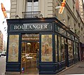 Devanture Boulangerie 159 rue Ordener.jpg 1,605 × 1,434; 518 KB