Category:Borough of North East Lincolnshire
Jump to navigation
Jump to search
North East Lincolnshire is a unitary authority within the ceremonial county of Lincolnshire, part of the former Humberside.
unitary authority in the Yorkshire and the Humber region of England   | |||||
| Upload media | |||||
| Instance of | |||||
|---|---|---|---|---|---|
| Part of | |||||
| Location |
| ||||
| Capital | |||||
| Legislative body |
| ||||
| Inception |
| ||||
| Population |
| ||||
| Area |
| ||||
| Replaces | |||||
| official website | |||||
 | |||||
Subcategories
This category has the following 26 subcategories, out of 26 total.
A
B
C
E
G
H
I
L
M
- Maps of North East Lincolnshire (10 F)
N
- New Waltham (86 F)
P
S
W
- West Ravendale (70 F)
Media in category "Borough of North East Lincolnshire"
The following 120 files are in this category, out of 120 total.
-
 A distant Haile Sands Fort - geograph.org.uk - 6500743.jpg 1,024 × 768; 151 KB
-
 Above us only sky - geograph.org.uk - 4956237.jpg 2,174 × 1,591; 1.05 MB
-
 Alfred Enderby Ltd - geograph.org.uk - 5624266.jpg 1,600 × 1,064; 447 KB
-
 Amenity grass and trees - geograph.org.uk - 5423282.jpg 1,024 × 768; 283 KB
-
 Battered groyne - geograph.org.uk - 4968952.jpg 1,024 × 768; 228 KB
-
 Beach and sea wall at Grimsby - geograph.org.uk - 5394298.jpg 800 × 585; 119 KB
-
 Beach near Grimsby docks - geograph.org.uk - 5394556.jpg 800 × 600; 141 KB
-

-

-
 Branch line and sidings, Grimsby - geograph.org.uk - 5969783.jpg 1,024 × 768; 164 KB
-
 Bridge over the River Freshney - geograph.org.uk - 6139404.jpg 1,600 × 1,065; 714 KB
-
 Bridleway alongside the River Freshney - geograph.org.uk - 6139215.jpg 1,600 × 1,065; 751 KB
-
 Bridleway alongside the River Freshney - geograph.org.uk - 6139219.jpg 1,600 × 1,065; 684 KB
-
 Bridleway towards Tannant Way - geograph.org.uk - 6139211.jpg 1,600 × 1,065; 550 KB
-

-

-

-
 Buck Beck outfall - geograph.org.uk - 5255921.jpg 640 × 427; 57 KB
-
 Buildings on Wickham Road, Grimsby Docks - geograph.org.uk - 5625424.jpg 1,600 × 1,064; 582 KB
-
 Bus stop on Great Coates Road A1136 - geograph.org.uk - 4697038.jpg 1,024 × 768; 178 KB
-
 Car Park at Humberston Fitties - geograph.org.uk - 5633144.jpg 1,600 × 1,065; 459 KB
-
 Care home on Second Avenue Nunsthorpe - geograph.org.uk - 4697069.jpg 1,024 × 768; 158 KB
-
 Cleethorpes beach - geograph.org.uk - 5388636.jpg 800 × 475; 71 KB
-
 Cleethorpes Nature Reserve - geograph.org.uk - 5634853.jpg 1,600 × 1,065; 314 KB
-
 Coastal path - geograph.org.uk - 5792288.jpg 800 × 600; 104 KB
-
 Coastal path south of Grimsby Docks - geograph.org.uk - 5792907.jpg 800 × 600; 72 KB
-
 Coastal path, Humberston Fitties - geograph.org.uk - 5919902.jpg 1,024 × 768; 166 KB
-
 Cold store close to the sea wall. - geograph.org.uk - 6334482.jpg 1,024 × 683; 123 KB
-
 Cold store near Grimsby docks - geograph.org.uk - 5394554.jpg 800 × 531; 81 KB
-
 Cromwell Road roundabout ahead - geograph.org.uk - 4696996.jpg 1,024 × 768; 156 KB
-
 Cycleway junction alongside Peaks Parkway A16 - geograph.org.uk - 4697091.jpg 1,024 × 768; 205 KB
-
 Derelict building on Stuart Worley Street - geograph.org.uk - 5625144.jpg 1,600 × 1,064; 629 KB
-

-
 Dock road towards Grimsby Dock Tower - geograph.org.uk - 5621078.jpg 1,600 × 1,064; 432 KB
-
 Drain between Thorpe Park and Pleasure Island - geograph.org.uk - 4949062.jpg 1,024 × 768; 204 KB
-
 Drain exits to North Sea by Pleasure Island, Cleethorpes - geograph.org.uk - 5369504.jpg 5,376 × 3,024; 2.53 MB
-
 E-factor, grimsby - geograph.org.uk - 4969803.jpg 1,024 × 768; 126 KB
-
 Fish Smoking House - geograph.org.uk - 5625412.jpg 1,600 × 1,064; 472 KB
-
 Fishy business - geograph.org.uk - 6214537.jpg 1,024 × 683; 156 KB
-
 Flocks of wading birds (mainly Knots) over The Humber - geograph.org.uk - 5137481.jpg 2,560 × 1,920; 1.05 MB
-
 Footbridge on Harrington Street, Cleethorpes - geograph.org.uk - 5619528.jpg 1,600 × 1,064; 483 KB
-
 Footbridge over the railway - geograph.org.uk - 4948193.jpg 1,024 × 768; 156 KB
-
 Foreshore, New Clee - geograph.org.uk - 4969872.jpg 1,024 × 768; 157 KB
-
 Former Holme Hill School - geograph.org.uk - 4968996.jpg 1,024 × 768; 121 KB
-

-
 Fuller Street - geograph.org.uk - 4969473.jpg 1,024 × 768; 175 KB
-
 Gloucester Avenue - geograph.org.uk - 4697061.jpg 1,024 × 768; 132 KB
-
 Graffiti covered sea wall. - geograph.org.uk - 6334479.jpg 1,024 × 683; 113 KB
-
 Grant Thorold Park - geograph.org.uk - 4969811.jpg 1,024 × 768; 149 KB
-
 Grimsby auditorium - geograph.org.uk - 4696992.jpg 1,024 × 768; 187 KB
-
 Grimsby foreshore - geograph.org.uk - 4969553.jpg 1,024 × 701; 121 KB
-
 Grimsby Neighbourhood Centre - geograph.org.uk - 4969854.jpg 1,024 × 768; 151 KB
-
 Haines Watts Grimsby - geograph.org.uk - 5284453.jpg 674 × 430; 70 KB
-
 Heading south along the A16 in Grimsby - geograph.org.uk - 5396319.jpg 800 × 547; 135 KB
-
 Healing and Complementary Therapy Centre - geograph.org.uk - 4969786.jpg 1,024 × 768; 105 KB
-
 High tide in Cleethorpes - geograph.org.uk - 5792898.jpg 800 × 600; 111 KB
-
 Houses along Laceby Road, Grimsby - geograph.org.uk - 4751753.jpg 3,847 × 2,447; 4.89 MB
-

-

-
 Is this really Grimsby Docks^ - geograph.org.uk - 4696906.jpg 1,024 × 791; 116 KB
-
 It was an icy cold day - geograph.org.uk - 5371767.jpg 5,376 × 3,024; 2.35 MB
-
 Junction in Thorpe Park - geograph.org.uk - 4949058.jpg 1,024 × 768; 208 KB
-
 Keeping Cleethorpes tidy - geograph.org.uk - 5371708.jpg 5,376 × 3,024; 1.87 MB
-
 Leap Ahead Day Nursery, Rutland Street - geograph.org.uk - 4969832.jpg 1,024 × 768; 132 KB
-
 Mud glorious mud - geograph.org.uk - 5110491.jpg 1,024 × 768; 147 KB
-
 Mural, Shalom Youth Centre - geograph.org.uk - 4969828.jpg 1,024 × 768; 129 KB
-
 Navigation beacon - geograph.org.uk - 4968940.jpg 1,024 × 768; 131 KB
-
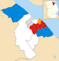 North East Lincolnshire UK local election 2024 map.svg 1,259 × 1,306; 289 KB
-
 Old Humberstone Road - geograph.org.uk - 5423255.jpg 1,024 × 768; 323 KB
-
 Open ground Nunsthorpe - geograph.org.uk - 4697077.jpg 1,024 × 768; 114 KB
-
 Outfall below Seafood Village - geograph.org.uk - 4969531.jpg 1,024 × 768; 214 KB
-

-
 Path in Carr Plantation - geograph.org.uk - 5454871.jpg 1,024 × 768; 290 KB
-
 Path in Weelsby Woods - geograph.org.uk - 5454885.jpg 1,024 × 768; 265 KB
-
 Path to Humber Bridge Road - geograph.org.uk - 5394563.jpg 800 × 600; 121 KB
-

-
 Promenade along the Humber at Grimsby - geograph.org.uk - 5391181.jpg 800 × 528; 103 KB
-
 Promenade approaching Cleethorpes from Grimsby - geograph.org.uk - 5371710.jpg 5,376 × 3,024; 1.94 MB
-
 Railway footbridge at Blundell Park - geograph.org.uk - 5792900.jpg 800 × 600; 142 KB
-
 Ramp to the beach - geograph.org.uk - 4948720.jpg 1,024 × 768; 124 KB
-
 Scrap Yard by the railway - geograph.org.uk - 4855302.jpg 2,000 × 1,333; 1.33 MB
-

-
 Sea wall near Blundell Park - geograph.org.uk - 5792903.jpg 800 × 600; 78 KB
-
 Sea wall path - geograph.org.uk - 4948189.jpg 1,024 × 768; 119 KB
-
 Sea wall, Grimsby - geograph.org.uk - 5919853.jpg 1,024 × 768; 161 KB
-
 Sea wall, Grimsby - geograph.org.uk - 5919857.jpg 1,024 × 768; 130 KB
-
 Smoking fish - geograph.org.uk - 5371793.jpg 5,376 × 3,024; 1.45 MB
-
 Sofa on the beach - geograph.org.uk - 5388610.jpg 800 × 505; 79 KB
-
 Straight on for Nunsthorpe - geograph.org.uk - 4697066.jpg 1,024 × 768; 160 KB
-
 Tarmac Plant, Westside Road, Grimsby Docks - geograph.org.uk - 5621075.jpg 1,600 × 1,064; 427 KB
-
 Terraced housing 21st century style - geograph.org.uk - 4969858.jpg 1,024 × 768; 136 KB
-
 The church of St. Stephen and St. John - geograph.org.uk - 4968993.jpg 1,024 × 768; 121 KB
-
 The Humber shore - geograph.org.uk - 4948722.jpg 1,024 × 768; 134 KB
-
 The new sea wall - geograph.org.uk - 5110493.jpg 1,024 × 768; 95 KB
-
 The Pear Tree public house - geograph.org.uk - 4696877.jpg 1,024 × 768; 150 KB
-
 The sea wall near Cleethorpes - geograph.org.uk - 4948729.jpg 1,024 × 768; 107 KB
-
 The sea wall near Cleethorpes - geograph.org.uk - 4948733.jpg 1,024 × 768; 128 KB
-
 There's room for a lot of fish in there - geograph.org.uk - 5792905.jpg 800 × 600; 117 KB
-
 Time for a chat - geograph.org.uk - 4696912.jpg 1,024 × 768; 185 KB
-
 Turn right at this tree stump - geograph.org.uk - 4697087.jpg 1,024 × 768; 170 KB
-

-
 Unnamed drain meets the sea - geograph.org.uk - 5919894.jpg 1,024 × 768; 156 KB
-
 Vehicle scrapyard beside the railway - geograph.org.uk - 5792927.jpg 800 × 600; 150 KB
-
 View across the Humber - geograph.org.uk - 4968894.jpg 1,024 × 768; 121 KB
-
 View across the Humber estuary - geograph.org.uk - 5054888.jpg 800 × 577; 77 KB
-
 View from the footbridge - geograph.org.uk - 4948718.jpg 1,024 × 768; 116 KB
-
 View towards Seafood Village - geograph.org.uk - 4969540.jpg 1,024 × 768; 120 KB
-

-
 View towards the Water Tower at Cleethorpes - geograph.org.uk - 4968899.jpg 1,024 × 768; 116 KB
-
 View towards Wybers Wood - geograph.org.uk - 4969467.jpg 1,024 × 768; 300 KB
-

-

-
 Weelsby Woods - geograph.org.uk - 5454841.jpg 1,024 × 768; 178 KB
-
 Weelsby Woods - geograph.org.uk - 5454850.jpg 1,024 × 768; 263 KB
-
 Welcome to Pleasure Island - geograph.org.uk - 4696899.jpg 1,024 × 768; 167 KB
-
 Wheatfield within Weelsby Woods - geograph.org.uk - 5454858.jpg 1,024 × 768; 266 KB
-
 Why the path got narrower - geograph.org.uk - 5454879.jpg 1,024 × 768; 310 KB
-
 Woad Lane crosses the A180 - geograph.org.uk - 5011315.jpg 1,500 × 1,070; 145 KB
-
 Wreck off New Clee - geograph.org.uk - 4968989.jpg 1,024 × 768; 99 KB
-
 Wreck on the beach at Grimsby - geograph.org.uk - 5054873.jpg 800 × 716; 123 KB


_over_The_Humber_-_geograph.org.uk_-_5137481.jpg)


