Category:Borgbeuningen, Beuningen
Jump to navigation
Jump to search
| Object location | | View all coordinates using: OpenStreetMap |
|---|
building in Losser, Netherlands  | |||||
| Upload media | |||||
| Instance of | |||||
|---|---|---|---|---|---|
| Location | Beuningen, Overijssel, Losser, Overijssel, Netherlands | ||||
| Street address |
| ||||
| Located on street |
| ||||
| Heritage designation |
| ||||
 | |||||
|
This is a category about rijksmonument number 513513
|
| Address |
|
Subcategories
This category has only the following subcategory.
B
Media in category "Borgbeuningen, Beuningen"
The following 51 files are in this category, out of 51 total.
-

-
 Boerderij "OLDE AUSTI" DETHMERS 1 - Beuningen - 20467389 - RCE.jpg 1,200 × 900; 181 KB
-
 Borgbosweg basis van de Sterrebos - Beuningen - 20034233 - RCE.jpg 1,190 × 1,200; 530 KB
-
 Borgbosweg gezichtas op Gildehaus - Beuningen - 20034231 - RCE.jpg 1,190 × 1,200; 542 KB
-
 Borgbosweg zichtas op Austinberg - Beuningen - 20034236 - RCE.jpg 1,197 × 1,200; 462 KB
-
 Borgbosweg zichtas richting Gildehaus - Beuningen - 20034228 - RCE.jpg 1,197 × 1,200; 526 KB
-
 Borgbosweg zichtas richting Gildehaus - Beuningen - 20034235 - RCE.jpg 1,197 × 1,200; 491 KB
-
 Hooischuur, noordwestzijde - Beuningen - 20034222 - RCE.jpg 1,200 × 1,197; 507 KB
-
 Hooischuur, westgevel - Beuningen - 20034223 - RCE.jpg 1,195 × 1,200; 443 KB
-
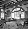
 Interieur hal - Beuningen - 20034285 - RCE.jpg 1,195 × 1,200; 232 KB
-
 Interieur hal - Beuningen - 20034286 - RCE.jpg 1,190 × 1,200; 217 KB
-
 Interieur keuken - Beuningen - 20034291 - RCE.jpg 1,188 × 1,200; 249 KB
-
 Interieur slaapkamer - Beuningen - 20034292 - RCE.jpg 1,188 × 1,200; 230 KB
-
 Interieur trap vanuit woonkamer - Beuningen - 20034290 - RCE.jpg 1,190 × 1,200; 268 KB
-
 Interieur woonkamer - Beuningen - 20034287 - RCE.jpg 1,190 × 1,200; 267 KB
-
 Interieur woonkamer - Beuningen - 20034288 - RCE.jpg 1,190 × 1,200; 291 KB
-
 Interieur woonkamer - Beuningen - 20034289 - RCE.jpg 1,188 × 1,200; 266 KB
-
 Kruisvormige vijver naar het zuiden - Beuningen - 20034241 - RCE.jpg 1,200 × 1,200; 518 KB
-
 Noordgevel rietgedekte villa, met veranda, tuin rondom - Beuningen - 20398916 - RCE.jpg 1,190 × 1,200; 400 KB
-
 Schuur UIT AGELO SVEN LOSSER 90 - Beuningen - 20467388 - RCE.jpg 944 × 880; 121 KB
-
 Schuur UIT AGELO SVEN LOSSER 91 - Beuningen - 20467387 - RCE.jpg 1,200 × 900; 180 KB
-
 Schuur UIT AGELO SVEN LOSSER 92 - Beuningen - 20467390 - RCE.jpg 1,200 × 900; 189 KB
-
 Singravenweg naar het zuiden - Beuningen - 20034234 - RCE.jpg 1,195 × 1,200; 533 KB
-

-
 Sterrebos hoofdas naar het westen - Beuningen - 20034247 - RCE.jpg 1,197 × 1,200; 488 KB
-
 Sterrebos hoofdas naar het westen - Beuningen - 20034253 - RCE.jpg 1,197 × 1,200; 543 KB
-
 Sterrebos kruisas - Beuningen - 20034254 - RCE.jpg 1,195 × 1,200; 541 KB
-
 Sterrebos kruisvormige vijver naar het noord-westen - Beuningen - 20034248 - RCE.jpg 1,200 × 1,197; 531 KB
-
 Sterrebos middenas - Beuningen - 20034240 - RCE.jpg 1,197 × 1,200; 528 KB
-
 Sterrebos rechthoekige vijver naar het zuiden - Beuningen - 20034242 - RCE.jpg 1,195 × 1,200; 559 KB
-
 Sterrebos sluitlaan naar het noorden - Beuningen - 20034238 - RCE.jpg 1,190 × 1,200; 539 KB
-
 Sterrebos sluitlaan naar het zuiden - Beuningen - 20034239 - RCE.jpg 1,197 × 1,200; 553 KB
-
 Sterrebos verzande dinkelarm - Beuningen - 20034237 - RCE.jpg 1,195 × 1,200; 566 KB
-
 Sterrebos zuidelijke snijpunt van lanen - Beuningen - 20034249 - RCE.jpg 1,200 × 1,200; 521 KB
-
 Sterrebos, hoofdas naar het oosten - Beuningen - 20034246 - RCE.jpg 1,200 × 1,199; 481 KB
-
 Sterrebos, hoofdas naar het westen - Beuningen - 20034244 - RCE.jpg 1,195 × 1,200; 493 KB
-
 Sterrebos, kruisas - Beuningen - 20034251 - RCE.jpg 1,193 × 1,200; 503 KB
-
 Sterrebos, kruisassen naar het noord-oosten - Beuningen - 20034252 - RCE.jpg 1,195 × 1,200; 547 KB
-

-
 Sterrebos, sluitlaan vanaf het zuid-oosten met dinkel - Beuningen - 20034245 - RCE.jpg 1,200 × 1,197; 514 KB
-
 Tuinbeeld - Beuningen - 20034281 - RCE.jpg 1,197 × 1,200; 537 KB
-
 Tuinbeeld in tuin - Beuningen - 20034280 - RCE.jpg 1,197 × 1,200; 475 KB
-
 Uitzichtas Borgbosweg naar Oldenzaal - Beuningen - 20034226 - RCE.jpg 1,200 × 1,200; 555 KB
-
 Uitzichtas Borgbosweg naar Oldenzaal - Beuningen - 20034227 - RCE.jpg 1,190 × 1,200; 432 KB
-
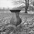 Voetstuk zonnewijzer in tuin - Beuningen - 20034282 - RCE.jpg 1,195 × 1,200; 460 KB
-
 Westgevel - Beuningen - 20034284 - RCE.jpg 1,192 × 1,200; 476 KB
-
 Zichtas landgoed richting Hakenberg naar het zuiden - Beuningen - 20034230 - RCE.jpg 1,200 × 1,200; 512 KB
-
 Zichtassen, links Singravenweg rechts Borgbosweg - Beuningen - 20034232 - RCE.jpg 1,195 × 1,200; 483 KB
-
 Zuid-oost zijde schans nabij Borgbosweg - Beuningen - 20034225 - RCE.jpg 1,197 × 1,200; 505 KB
-
 Zuidgevel - Beuningen - 20034283 - RCE.jpg 1,193 × 1,200; 433 KB
-
 Zuidzijde van de schans in de omgeving van Borgbosweg - Beuningen - 20034224 - RCE.jpg 1,200 × 1,197; 576 KB


