Category:Bogerse Velden (Lier)
Jump to navigation
Jump to search
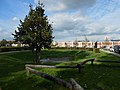
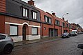
Nederlands: Bogerse Velden is de naam van een stadswijk (voormalig landbouwgebied) aan de noordwestelijke rand van Lier, bestaande uit bijna 20 straten met namen uit het zonnestelsel of de dierenriem. In het zuidelijk deel nieuwbouw uit de jaren 1930, deels sociale huisvesting. Rond 2015-25 vele nieuwe woningen en flatgebouwen in het meer noordelijk deel, deels ook sociale huisvesting.
English: Bogerse Velden is the name of an area (former agricultural area) on the north-western outskirts of Lier, consisting of almost 20 streets with names from the solar system or the zodiac. In the southern part, new buildings from the 1930s, partly social housing. Around 2015-25 many new houses and apartment buildings were built in the more northern part, partly also social housing.
| Object location | | View all coordinates using: OpenStreetMap |
|---|
Media in category "Bogerse Velden (Lier)"
The following 13 files are in this category, out of 13 total.
-
 Bogerse Plassen Infobord.jpg 3,264 × 1,836; 2.68 MB
-
 Bogerse Velden wadi.jpg 4,608 × 3,456; 3.3 MB
-
 Bogerse7kranen.jpg 6,000 × 4,000; 7.39 MB
-
 BV10 Kreefstraat Leeuwstraat.jpg 6,000 × 4,000; 6.52 MB
-
 BV10 Leeuwstraat 24.jpg 6,000 × 4,000; 6.71 MB
-
 BV12 Weegschaal Schorpioenstraat.jpg 6,000 × 4,000; 6.94 MB
-
 Maanstraat 5-17.jpg 6,000 × 4,000; 6.76 MB
-
 Speeltuin Bogerse Velden noordoost.jpg 4,608 × 3,456; 3.39 MB
-
 Speeltuin Bogerse Velden zuidwest.jpg 4,608 × 3,456; 3.37 MB
-
 Speeltuin Stierstraat plein.jpg 4,608 × 3,456; 3.41 MB
-
 Speeltuin Stierstraat toren.jpg 3,456 × 4,608; 3.32 MB
-
 Zonstraat 20-6.jpg 6,000 × 4,000; 6.95 MB
-
 Zonstraat 4-2.jpg 6,000 × 4,000; 5.33 MB


