Category:Boerderij Meijendel, Wassenaar
Jump to navigation
Jump to search
| Object location | | View all coordinates using: OpenStreetMap |
|---|
farmhouse in Wassenaar, Netherlands  | |||||
| Upload media | |||||
| Instance of | |||||
|---|---|---|---|---|---|
| Part of | |||||
| Location | Wassenaar, South Holland, Netherlands | ||||
| Street address |
| ||||
| Heritage designation |
| ||||
 | |||||
|
This is a category about rijksmonument number 524529
|
|
This is a category about rijksmonument number 524530
|
|
This is a category about rijksmonument number 524531
|
| Address |
|
Media in category "Boerderij Meijendel, Wassenaar"
The following 11 files are in this category, out of 11 total.
-
 Boerderij Meijendel Wassenaar P1280417.jpg 4,000 × 2,672; 5.76 MB
-
 Boerderij Meijendel Wassenaar P1280418.jpg 4,000 × 2,672; 6.14 MB
-
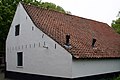 Boerderij Meijendel, schuur.JPG 3,072 × 2,048; 2.33 MB
-
 Boerderij Meijendel, veestal.JPG 3,072 × 2,048; 2.42 MB
-
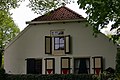 Boerderij Meijendel, woonhuis.JPG 3,072 × 2,048; 2.14 MB
-
 Boerderij Meyendel restaurant, Wassenaar, 2022.jpg 5,597 × 3,721; 11.83 MB
-
 Meyendel, aanzicht - Wassenaar - 20250446 - RCE.jpg 1,200 × 948; 302 KB
-
 Meyendel, overzicht - Wassenaar - 20250444 - RCE.jpg 1,200 × 953; 360 KB
-
 Meyendel, overzicht - Wassenaar - 20250445 - RCE.jpg 1,200 × 956; 280 KB
-
 Meyendel, schuur - Wassenaar - 20250447 - RCE.jpg 1,200 × 949; 352 KB
-
 Winter in Meyendel (8405623959).jpg 1,276 × 850; 972 KB


.jpg)