Category:Blumenhof
Jump to navigation
Jump to search
| Object location | | View all coordinates using: OpenStreetMap |
|---|
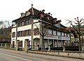
manor house in Kehrsatz in the canton of Bern, Switzerland  | |||||
| Upload media | |||||
| Instance of | |||||
|---|---|---|---|---|---|
| Part of | |||||
| Location | Kehrsatz, Bern-Mittelland administrative district, Bernese Mittelland administrative region, Bern, Switzerland | ||||
| Street address |
| ||||
| Heritage designation | |||||
| Inception |
| ||||
 | |||||
Media in category "Blumenhof"
The following 10 files are in this category, out of 10 total.
-
 Aberli NETscharner.jpg 3,155 × 1,871; 3.13 MB
-
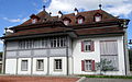 Campagne Blumenhof 01.JPG 4,896 × 3,045; 3.31 MB
-
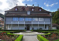
 Campagne Blumenhof 02.JPG 4,896 × 3,096; 8.23 MB
-
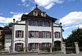
 Campagne Blumenhof 03.JPG 4,817 × 3,375; 8.58 MB
-
 Campagne Blumenhof 04.JPG 4,896 × 3,380; 3.34 MB
-
 Campagne Blumenhof 05.JPG 4,709 × 3,509; 4.24 MB
-
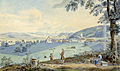
 CH-NB - Kehrsatz, von Norden - Collection Gugelmann - GS-GUGE-ABERLI-C-8.tif 5,700 × 3,899, 2 pages; 35.43 MB
-
 Funck77 0026.jpg 3,372 × 2,456; 1.9 MB
-
 Schloss Kehrsatz 03.JPG 4,896 × 3,672; 3.73 MB
-
 Schloss Kehrsatz 11.JPG 3,672 × 4,896; 10 MB


