Category:Blaeu Atlas of Scotland 1654
Jump to navigation
Jump to search
atlas of Scotland and Ireland published 1654 | |||||
| Upload media | |||||
| Instance of |
| ||||
|---|---|---|---|---|---|
| Point in time |
| ||||
| |||||
Source
[edit]Media in category "Blaeu Atlas of Scotland 1654"
The following 54 files are in this category, out of 54 total.
-
 Blaeu - Atlas of Scotland 1654 - ABERDONIA & BANFIA - Aberdeenshire and Banffshire.jpg 6,566 × 5,075; 7.44 MB
-
 Blaeu - Atlas of Scotland 1654 - ANNANDIÆ - Lower Annandale.jpg 6,075 × 4,984; 3.91 MB
-
 Blaeu - Atlas of Scotland 1654 - ARANIA - The Isle of Arran.jpg 6,184 × 4,667; 5.18 MB
-
 Blaeu - Atlas of Scotland 1654 - BRAID-ALLABAN - The Central Highlands.jpg 6,317 × 4,959; 7.25 MB
-
 Blaeu - Atlas of Scotland 1654 - BUTHE INSULA - The Isle of Bute.jpg 6,175 × 4,692; 5.11 MB
-
 Blaeu - Atlas of Scotland 1654 - CANTYRA - Kintyre.jpg 5,983 × 4,917; 5.61 MB
-
 Blaeu - Atlas of Scotland 1654 - CARRICTA BOREALIS - Mid Ayrshire.jpg 6,341 × 5,017; 7.53 MB
-
 Blaeu - Atlas of Scotland 1654 - CARRICTA MERIDIONALIS - Carrick.jpg 6,200 × 4,534; 6.45 MB
-
 Blaeu - Atlas of Scotland 1654 - CATHENESIA - Caithness.jpg 6,209 × 4,617; 5.73 MB
-
 Blaeu - Atlas of Scotland 1654 - COILA - Kyle.jpg 6,609 × 5,300; 7.54 MB
-
 Blaeu - Atlas of Scotland 1654 - CVNINGHAMIA - Cunningham.jpg 6,600 × 4,925; 6.96 MB
-
 Blaeu - Atlas of Scotland 1654 - EVIA ET ESCIA - Eskdale.jpg 6,275 × 5,000; 5.86 MB
-
 Blaeu - Atlas of Scotland 1654 - EXTIMA SCOTIÆ - Northern Scotland.jpg 6,291 × 5,017; 7.47 MB
-
 Blaeu - Atlas of Scotland 1654 - FIFÆ PARS OCCIDENTALIS - The West Part of Fife.jpg 6,334 × 4,917; 6.63 MB
-
 Blaeu - Atlas of Scotland 1654 - FIFÆ PARS ORIENTALIS - The East Part of Fife.jpg 6,258 × 4,933; 6.04 MB
-
 Blaeu - Atlas of Scotland 1654 - FIFÆ VICECOMITATUS - Fife.jpg 6,258 × 4,975; 6.17 MB
-
 Blaeu - Atlas of Scotland 1654 - GALLOVIDIA - Galloway.jpg 6,242 × 4,941; 6.62 MB
-
 Blaeu - Atlas of Scotland 1654 - GALLOVIDIÆ PARS MEDIA - West Kirkcudbright.jpg 6,417 × 5,008; 7.62 MB
-
 Blaeu - Atlas of Scotland 1654 - GALLOVIDIÆ PARS OCCIDENTALIOR - Wigtownshire.jpg 6,175 × 4,891; 6.06 MB
-
 Blaeu - Atlas of Scotland 1654 - GLOTTIANA PRÆFECTVRA INFERIOR - Lower Clydesdale.jpg 6,359 × 4,741; 7.55 MB
-
 Blaeu - Atlas of Scotland 1654 - GLOTTIANA PRÆFECTVRA SVPERIOR - Upper Clydesdale.jpg 6,400 × 4,709; 6.84 MB
-
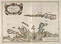
 Blaeu - Atlas of Scotland 1654 - ILA INSVLA - The Isle of Ila.jpg 6,300 × 4,808; 5.38 MB
-
-
 Blaeu - Atlas of Scotland 1654 - INSVLÆ QVÆDAM MINORES - The Small Isles.jpg 6,367 × 4,700; 4.39 MB
-
 Blaeu - Atlas of Scotland 1654 - IVRA INSVLA - The Isle of Jura.jpg 6,284 × 4,833; 5.8 MB
-
 Blaeu - Atlas of Scotland 1654 - KIRCVBRIENSIS - East Kirkcudbright.jpg 6,434 × 5,009; 7.57 MB
-
 Blaeu - Atlas of Scotland 1654 - KNAPDALIA - Knapdale.jpg 6,391 × 4,966; 6.28 MB
-
 Blaeu - Atlas of Scotland 1654 - LAVDELIA - Lauderdale.jpg 6,208 × 4,792; 5.11 MB
-
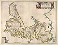
 Blaeu - Atlas of Scotland 1654 - LEOGVS ET HARAIA - Lewis and Harris.jpg 6,192 × 4,675; 5.71 MB
-
 Blaeu - Atlas of Scotland 1654 - LEVINIA - Dunbarton.jpg 6,350 × 4,733; 6.58 MB
-
 Blaeu - Atlas of Scotland 1654 - LIDALIA - Liddesdale.jpg 6,250 × 4,967; 6.09 MB
-
 Blaeu - Atlas of Scotland 1654 - LORNA - The Firth of Lorn.jpg 6,333 × 4,725; 6.15 MB
-
 Blaeu - Atlas of Scotland 1654 - LOTHIAN AND LINLITQVO - The Lothians.jpg 6,479 × 4,525; 6.25 MB
-
 Blaeu - Atlas of Scotland 1654 - MERCIA - Berwickshire.jpg 6,217 × 4,667; 5.55 MB
-
 Blaeu - Atlas of Scotland 1654 - MORAVIA - Moray and Nairn.jpg 6,441 × 4,950; 7.16 MB
-
 Blaeu - Atlas of Scotland 1654 - MVLA INSVLA - The Isle of Mull.jpg 6,392 × 5,067; 6.38 MB
-
 Blaeu - Atlas of Scotland 1654 - NITHIA - Nithsdale.jpg 6,325 × 4,633; 7.23 MB
-
 Blaeu - Atlas of Scotland 1654 - ORCADVM ET SCHETLANDIÆ - Orkney and Shetland.jpg 6,300 × 4,800; 7.38 MB
-
 Blaeu - Atlas of Scotland 1654 - RENFROANA - Renfrew.jpg 6,392 × 4,700; 6.78 MB
-
 Blaeu - Atlas of Scotland 1654 - SCOTIA ANTIQUA - Old Scotland.jpg 6,492 × 4,975; 8.4 MB
-
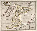
 Blaeu - Atlas of Scotland 1654 - SCOTIA REGNUM - Kingdom of Scotland.jpg 6,492 × 5,000; 9.41 MB
-
 Blaeu - Atlas of Scotland 1654 - SKIA - The Isle of Skye.jpg 6,208 × 4,858; 6.1 MB
-
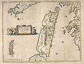
 Blaeu - Atlas of Scotland 1654 - SOVTHERLANDIA - Southeast Sutherland.jpg 6,209 × 4,508; 6.05 MB
-
 Blaeu - Atlas of Scotland 1654 - STERLINENSIS - Stirlingshire.jpg 6,233 × 4,841; 6.3 MB
-
 Blaeu - Atlas of Scotland 1654 - STRATH-NAVERNIA - Strath Naver and Strathmore.jpg 6,000 × 4,917; 6.46 MB
-
 Blaeu - Atlas of Scotland 1654 - TEVIOTIA - Teviotdale.jpg 6,342 × 5,066; 7.47 MB
-
 Blaeu - Atlas of Scotland 1654 - TVEDIA - Upper Tweedsdale.jpg 6,075 × 4,958; 6.98 MB
-
 Blaeu - Atlas of Scotland 1654 - VISTVS INSVLA - The Uists and Barra.jpg 6,633 × 5,225; 6.3 MB
-
 Blaeu - Atlas of Scotland 1654 - ÆBUDÆ INSULÆ - The Hebrides.jpg 6,333 × 4,600; 5.72 MB
-
 Blaeu.1654.submap.Ptolemy.Damnij.jpg 1,584 × 940; 318 KB
-
 Blaeu.Atlas.of.Scotland.1654.Renfrew.Govan.jpg 1,478 × 674; 142 KB
-
 Joan Blaeu - Merse - 1654 - Area 'Duns Grinnla Fogo'.png 945 × 859; 1.35 MB
-
 North Ronaldshay Blaeu - Atlas of Scotland 1654.jpg 419 × 461; 150 KB
-
 Timothy Pont's Map of Cunninghame by Blaeu. Stewarton area.jpg 4,896 × 2,752; 2.76 MB


