Category:Blackwell in the Peak
Jump to navigation
Jump to search
English: Blackwell is a village in the Derbyshire Dales local government district of Derbyshire, England, on the A6 main road between Bakewell and Buxton.
village and civil parish in Derbyshire Dales district, Derbyshire, England  | |||||
| Upload media | |||||
| Instance of | |||||
|---|---|---|---|---|---|
| Location | Derbyshire Dales, Derbyshire, East Midlands, England | ||||
| Population |
| ||||
| Different from | |||||
 | |||||
Subcategories
This category has the following 2 subcategories, out of 2 total.
B
- Blackwell Mill (6 F)
C
- Chee Tor Tunnels (25 F)
Media in category "Blackwell in the Peak"
The following 200 files are in this category, out of 220 total.
(previous page) (next page)-
 'House made from limestone in Blackwell' updated - geograph.org.uk - 5068733.jpg 3,456 × 2,304; 5.35 MB
-
 A cutting on the Monsal Trail - geograph.org.uk - 5068582.jpg 3,456 × 2,304; 4.72 MB
-
 A path marker down to Chee Dale - geograph.org.uk - 5068691.jpg 3,456 × 2,304; 5.01 MB
-
 A quiet corner on the River Wye in spring - geograph.org.uk - 3948829.jpg 1,024 × 797; 323 KB
-
 A rainy end to the Monsal Trail - geograph.org.uk - 4303516.jpg 1,024 × 768; 249 KB
-
 A scattering of snow - geograph.org.uk - 5279523.jpg 4,896 × 3,672; 6.95 MB
-
 A view of Topleyhead Farm - geograph.org.uk - 6406617.jpg 4,941 × 3,375; 3.53 MB
-
 A wet weir on the Wye - geograph.org.uk - 4303523.jpg 1,024 × 768; 195 KB
-
 A6 - geograph.org.uk - 5494976.jpg 4,577 × 3,049; 1.93 MB
-
 A6 approaching Topley Pike Quarry - geograph.org.uk - 5568066.jpg 1,598 × 1,600; 1,022 KB
-
 A6 approaching woods on Calton Hill - geograph.org.uk - 5568060.jpg 1,600 × 1,200; 681 KB
-
 A6 in Wye Dale - geograph.org.uk - 5568063.jpg 1,600 × 1,200; 790 KB
-
 Abseiling from the viaduct - geograph.org.uk - 6492929.jpg 2,816 × 2,112; 1.7 MB
-
 Abseiling on former railway bridge - geograph.org.uk - 5609744.jpg 1,350 × 1,800; 475 KB
-
 Approaching the Blackwell Junction on the A6 - geograph.org.uk - 2940816.jpg 3,919 × 2,203; 3.13 MB
-
 B6049 south of Blackwell - geograph.org.uk - 5566485.jpg 1,600 × 1,066; 642 KB
-
 Blackwell 617759 3bacabbd.jpg 640 × 427; 112 KB
-
 Blackwell Cottages - geograph.org.uk - 2013342.jpg 3,888 × 2,592; 5.68 MB
-
 Blackwell Cottages - geograph.org.uk - 4957046.jpg 640 × 480; 100 KB
-
 Blackwell Dale - geograph.org.uk - 4766102.jpg 640 × 426; 103 KB
-
 Blackwell Dale - geograph.org.uk - 4766104.jpg 640 × 426; 82 KB
-
 Blackwell Dale - geograph.org.uk - 4766106.jpg 640 × 426; 69 KB
-

-
 Blackwell in the Peak SK17, UK - panoramio.jpg 2,816 × 2,112; 2.37 MB
-
 Blackwell Mill cottages - geograph.org.uk - 2489421.jpg 1,024 × 768; 409 KB
-
 Blackwell Mill Cottages - geograph.org.uk - 2942522.jpg 2,247 × 1,499; 2.52 MB
-
 Blackwell Mill Cottages - geograph.org.uk - 5493825.jpg 4,875 × 3,157; 1.65 MB
-
 Blackwell Mill Cottages - geograph.org.uk - 5493843.jpg 5,184 × 3,456; 1.94 MB
-
 Blackwell Mill cottages - geograph.org.uk - 5686952.jpg 2,000 × 1,333; 2.76 MB
-
 Blackwell Mill Cottages with Tunstead Limeworks Beyond - geograph.org.uk - 2829572.jpg 1,952 × 2,608; 922 KB
-
 Blackwell Mill Cottages, Wye Dale near Buxton - geograph.org.uk - 6421784.jpg 5,184 × 2,920; 6.33 MB
-
 Blackwell, Blackwell Dale - geograph.org.uk - 4329687.jpg 1,600 × 1,062; 1.09 MB
-
 Bridge over The Monsal Trail - geograph.org.uk - 4786491.jpg 640 × 426; 94 KB
-

-
 Bridleway by the River Wye - geograph.org.uk - 4786430.jpg 640 × 426; 111 KB
-
 Bridleway in Wye Dale - geograph.org.uk - 4786434.jpg 640 × 426; 100 KB
-
 Bridleway in Wye Dale - geograph.org.uk - 4786469.jpg 640 × 426; 102 KB
-
 Buildings at Blackwell Dale - geograph.org.uk - 4329683.jpg 1,600 × 1,062; 733 KB
-
 Calton Hill Landfill Site - geograph.org.uk - 5493838.jpg 5,184 × 3,456; 1.66 MB
-
 Calton Hill Quarry (geograph 2853998).jpg 640 × 424; 224 KB
-
 Calton Hill Quarry - Calcite - geograph.org.uk - 2853866.jpg 640 × 424; 312 KB
-
 Calton Hill Quarry - Calcite - geograph.org.uk - 2853871.jpg 640 × 424; 299 KB
-
 Calton Hill Quarry - geograph.org.uk - 2853893.jpg 640 × 424; 248 KB
-
 Calton Hill Quarry - geograph.org.uk - 2853950.jpg 640 × 424; 309 KB
-
 Calton Hill Quarry - geograph.org.uk - 2853984.jpg 640 × 424; 278 KB
-
 Calton Hill Quarry - geograph.org.uk - 2854002.jpg 640 × 424; 228 KB
-
 Calton Hill Quarry - geograph.org.uk - 2854060.jpg 640 × 424; 238 KB
-
 Calton Hill Quarry - geograph.org.uk - 2854064.jpg 640 × 402; 255 KB
-

-
 Car park by the A6 - geograph.org.uk - 4786420.jpg 640 × 426; 47 KB
-
 Car park by the A6 - geograph.org.uk - 4786427.jpg 640 × 426; 72 KB
-
 Car park in Wyedale. - geograph.org.uk - 4955502.jpg 640 × 480; 138 KB
-
 Carboniferous Volcanics - geograph.org.uk - 2853870.jpg 640 × 424; 264 KB
-
 Carboniferous Volcanics - geograph.org.uk - 2853884.jpg 640 × 424; 280 KB
-
 Chee Dale - geograph.org.uk - 6160665.jpg 1,600 × 1,200; 714 KB
-

-
 Chee Dale from Mosley Farm - geograph.org.uk - 335831.jpg 640 × 426; 99 KB
-
 Chee Dale Viaduct - geograph.org.uk - 4660481.jpg 640 × 298; 83 KB
-
 Chee Dale Viaduct - geograph.org.uk - 5493822.jpg 5,184 × 3,456; 1.97 MB
-
 Chee Dale, a gate on the riverside path - geograph.org.uk - 6147748.jpg 640 × 480; 115 KB
-
 Chee Dale, a small weir across the Wye - geograph.org.uk - 6151512.jpg 479 × 640; 125 KB
-

-

-
 Chee Dale, Derbyshire - geograph.org.uk - 6644451.jpg 2,800 × 1,867; 1.96 MB
-

-

-
 Chee Dale, footbridge over the Wye - geograph.org.uk - 6151469.jpg 480 × 640; 126 KB
-
 Chee Dale, inside Chee Tor Tunnel - geograph.org.uk - 6147724.jpg 640 × 480; 51 KB
-
 Chee Dale, mossy bark on a leaning tree - geograph.org.uk - 6151466.jpg 640 × 480; 125 KB
-

-

-

-
 Chee Tor - geograph.org.uk - 5494421.jpg 5,174 × 2,935; 1.71 MB
-
 Chee Tor No. 2 tunnel from inside No. 1 - geograph.org.uk - 6492917.jpg 2,816 × 2,112; 916 KB
-
 Churn Hole near Topley Pike - geograph.org.uk - 6406600.jpg 4,990 × 3,741; 7.36 MB
-
 Clump of trees - geograph.org.uk - 4766119.jpg 640 × 426; 65 KB
-
 Cottages at Blackwell Mill - geograph.org.uk - 3074186.jpg 800 × 600; 166 KB
-
 Covered reservoir - geograph.org.uk - 3848449.jpg 1,800 × 1,200; 294 KB
-
 Crossroads Farm - geograph.org.uk - 3864548.jpg 3,648 × 2,736; 2.45 MB
-
 Cutting on The Monsal Trail - geograph.org.uk - 4786492.jpg 640 × 426; 86 KB
-
 Cutting, The Monsal Trail - geograph.org.uk - 4786498.jpg 640 × 426; 102 KB
-
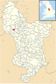 Derbyshire UK parish map highlighting Blackwell in the Peak.svg 888 × 1,308; 2.34 MB
-
 Dipper approaching nest, Chee Dale - geograph.org.uk - 4397824.jpg 2,257 × 2,258; 2 MB
-
 Dipper in Chee Dale (2) - geograph.org.uk - 4397818.jpg 2,268 × 2,269; 1.26 MB
-
 Dipper in Chee Dale - geograph.org.uk - 4397816.jpg 1,595 × 1,595; 767 KB
-
 Distant snows - geograph.org.uk - 5279540.jpg 4,896 × 3,672; 6.8 MB
-
 Disused quarry, Calton Hill - geograph.org.uk - 2853533.jpg 640 × 427; 89 KB
-
 Disused railway viaduct - geograph.org.uk - 4786481.jpg 640 × 426; 115 KB
-
 Disused railway viaduct near Wye Dale - geograph.org.uk - 5834279.jpg 5,184 × 3,888; 7.5 MB
-

-
 Diversion from Buxton rejoins the A6 - geograph.org.uk - 1831860.jpg 640 × 480; 52 KB
-
 Dusted with Snow - geograph.org.uk - 5279525.jpg 4,896 × 3,672; 6.75 MB
-
 Dusting of snow near Taddington - geograph.org.uk - 5673693.jpg 960 × 720; 664 KB
-
 Entrance of Topley Pike Quarry - geograph.org.uk - 5568068.jpg 1,600 × 1,280; 835 KB
-
 Entrance to Topley Pike Quarry - geograph.org.uk - 2200984.jpg 3,296 × 2,472; 1.13 MB
-
 Farm buildings in the trees - geograph.org.uk - 4766117.jpg 640 × 426; 61 KB
-
 Farm in Blackwell - geograph.org.uk - 1773588.jpg 640 × 480; 59 KB
-
 Farmland near Blackwell - geograph.org.uk - 4766120.jpg 640 × 426; 49 KB
-
 Farmland outside Blackwell - geograph.org.uk - 280563.jpg 640 × 480; 330 KB
-
 Footbridge over the Monsal Trail - geograph.org.uk - 3074182.jpg 800 × 600; 153 KB
-

-
 Footpath sign on the Monsal Trail - geograph.org.uk - 4797331.jpg 640 × 426; 124 KB
-
 Footpath sign, The Monsal Trail - geograph.org.uk - 4786499.jpg 640 × 426; 105 KB
-
 Footpath to Chee Dale - geograph.org.uk - 4786497.jpg 640 × 426; 98 KB
-
 Ford at Blackwell Mill Cottages - geograph.org.uk - 4413094.jpg 3,872 × 2,592; 4.09 MB
-
 Former railway viaduct near Topley Pike - geograph.org.uk - 5834296.jpg 3,888 × 5,184; 7.63 MB
-
 From the Blackwell path - geograph.org.uk - 5068791.jpg 3,456 × 2,304; 4.73 MB
-
 Gate, Topleyhead Farm - geograph.org.uk - 5705303.jpg 640 × 427; 78 KB
-
 Great Rocks Dale - geograph.org.uk - 5493847.jpg 3,456 × 4,704; 2.05 MB
-
 Head of Blackwell Dale - geograph.org.uk - 4766107.jpg 640 × 426; 86 KB
-
 Heading towards Topley Pike - geograph.org.uk - 2976144.jpg 640 × 479; 37 KB
-
 Horses in a field near Blackwell - geograph.org.uk - 2829575.jpg 2,570 × 1,928; 1.65 MB
-
 Horses on the skyline - geograph.org.uk - 3363951.jpg 427 × 640; 89 KB
-
 House made from limestone in Blackwell - geograph.org.uk - 2829587.jpg 2,376 × 1,783; 1.63 MB
-
 Igneous Sill - geograph.org.uk - 3003459.jpg 1,600 × 1,064; 509 KB
-
 Lane from the A6 to Blackwell - geograph.org.uk - 2829580.jpg 1,952 × 2,608; 1.33 MB
-
 Lane off A6 near Blackwell - geograph.org.uk - 2947130.jpg 1,280 × 853; 330 KB
-
 Lane to Blackwell - geograph.org.uk - 4766121.jpg 640 × 426; 80 KB
-
 Lay by outside Calton Farm - geograph.org.uk - 2755889.jpg 1,024 × 768; 127 KB
-
 Lay-by view towards A6 - geograph.org.uk - 1365883.jpg 640 × 480; 101 KB
-
 Limestone cliff by The Monsal Trail - geograph.org.uk - 4786495.jpg 640 × 426; 108 KB
-
 Limestone cliff, Blackwell Dale - geograph.org.uk - 4766105.jpg 640 × 426; 84 KB
-
 Limestone Scar - geograph.org.uk - 4786496.jpg 426 × 640; 96 KB
-
 Looking North on Sough Lane - geograph.org.uk - 3245274.jpg 2,112 × 2,118; 2.23 MB
-
 Lower Deep Dale - geograph.org.uk - 5307798.jpg 1,800 × 1,350; 668 KB
-
 Manor Farm, Blackwell - geograph.org.uk - 2829584.jpg 2,491 × 1,869; 1.38 MB
-
 Mantle Xenolith - geograph.org.uk - 2853897.jpg 640 × 424; 306 KB
-
 Monsal Trail - geograph.org.uk - 5493824.jpg 5,184 × 3,456; 1.69 MB
-
 Monsal Trail - geograph.org.uk - 5493846.jpg 3,456 × 4,751; 1.72 MB
-
 Monsal Trail, cutting and bridge near Chee Dale - geograph.org.uk - 5834284.jpg 4,785 × 3,588; 7.18 MB
-
 Monsal Trail, viaduct near Rusher Cutting - geograph.org.uk - 5834307.jpg 5,184 × 3,888; 4.94 MB
-

-
 Muddy Pasture - geograph.org.uk - 5705301.jpg 640 × 427; 103 KB
-
 Near the Churn Hole - geograph.org.uk - 2200967.jpg 3,296 × 2,472; 1.01 MB
-
 Oak tree, Blackwell - geograph.org.uk - 4766109.jpg 640 × 426; 73 KB
-
 Pair of Dippers, Chee Dale - geograph.org.uk - 4397820.jpg 2,773 × 2,774; 2.41 MB
-
 Pasture by the A6 - geograph.org.uk - 4766124.jpg 640 × 426; 54 KB
-
 Pasture by the A6 - geograph.org.uk - 4766125.jpg 640 × 426; 51 KB
-
 Pasture by the A6 - geograph.org.uk - 4766126.jpg 640 × 426; 49 KB
-
 Pasture near Topleyhead Farm - geograph.org.uk - 4185941.jpg 4,000 × 3,000; 2.54 MB
-
 Path down to Chee Dale - geograph.org.uk - 2839882.jpg 768 × 1,024; 263 KB
-

-
 Pennine Bridleway, Chee Dale - geograph.org.uk - 351557.jpg 640 × 480; 135 KB
-
 Picked out in snow - geograph.org.uk - 5279531.jpg 4,896 × 3,672; 7.05 MB
-
 Pillwell Lane - geograph.org.uk - 3848395.jpg 1,800 × 1,200; 331 KB
-
 Public Bridleway towards Blackwell - geograph.org.uk - 2947126.jpg 1,280 × 853; 577 KB
-
 Quiet day on the A6 - geograph.org.uk - 1765387.jpg 640 × 480; 56 KB
-
 Railway bridge - geograph.org.uk - 5609760.jpg 1,350 × 1,800; 563 KB
-
 Railway bridge over River Wye - geograph.org.uk - 5068577.jpg 3,456 × 2,304; 6.2 MB
-
 Railway Viaduct over the River Wye - geograph.org.uk - 4786431.jpg 640 × 426; 110 KB
-
 Railway Viaduct over the River Wye - geograph.org.uk - 4786437.jpg 640 × 426; 113 KB
-
 Railway viaduct, River Wye - geograph.org.uk - 5609747.jpg 1,800 × 1,350; 650 KB
-
 Railway Viaduct, Wye Dale - geograph.org.uk - 4786441.jpg 640 × 426; 120 KB
-
 Remains of a hedge - geograph.org.uk - 4766123.jpg 640 × 349; 48 KB
-
 River Wye - geograph.org.uk - 4786432.jpg 640 × 426; 117 KB
-
 River Wye - geograph.org.uk - 4786435.jpg 640 × 426; 114 KB
-
 River Wye - geograph.org.uk - 4786436.jpg 640 × 426; 108 KB
-
 River Wye - geograph.org.uk - 4786440.jpg 640 × 426; 119 KB
-
 River Wye - geograph.org.uk - 4786471.jpg 640 × 426; 116 KB
-
 River Wye - geograph.org.uk - 4786473.jpg 640 × 426; 119 KB
-
 River Wye - geograph.org.uk - 4786475.jpg 640 × 426; 109 KB
-
 River Wye - geograph.org.uk - 5493826.jpg 5,184 × 3,456; 2.01 MB
-
 River Wye - geograph.org.uk - 5609761.jpg 1,800 × 1,350; 630 KB
-
 River Wye - geograph.org.uk - 6161770.jpg 5,152 × 3,864; 7.38 MB
-
 River Wye and private access road to cottages - geograph.org.uk - 5068572.jpg 3,456 × 2,304; 5.95 MB
-
 River Wye and viaduct, Chee Dale - geograph.org.uk - 2839901.jpg 1,024 × 768; 361 KB
-
 River Wye flowing through Chee Dale - geograph.org.uk - 1765452.jpg 640 × 480; 102 KB
-
 River Wye looking upstream - geograph.org.uk - 3948847.jpg 1,024 × 768; 310 KB
-
 Road junction and farm at Blackwell - geograph.org.uk - 2839872.jpg 1,024 × 758; 278 KB
-
 Senners Lane - geograph.org.uk - 3848442.jpg 1,800 × 1,200; 311 KB
-
 Senners Lane cuts across the landscape - geograph.org.uk - 5673705.jpg 960 × 720; 574 KB
-
 Settlement on the hillside above Chee Dale - geograph.org.uk - 2489430.jpg 1,152 × 864; 307 KB
-
 Snow on the hills - geograph.org.uk - 5279537.jpg 4,896 × 3,672; 6.28 MB
-
 Snow over Blackwell - geograph.org.uk - 5279535.jpg 4,896 × 3,672; 6.42 MB
-
 Structures in the Quarry - geograph.org.uk - 2853876.jpg 640 × 424; 250 KB
-
 The A6 near Blackwell - geograph.org.uk - 2940820.jpg 3,829 × 2,243; 3.15 MB
-
 The B6049 in Blackwell Dale - geograph.org.uk - 2289570.jpg 3,296 × 2,472; 1.1 MB
-
 The end of the Monsal Trail - geograph.org.uk - 3706412.jpg 1,600 × 1,200; 926 KB
-
 The Monsal Trail - geograph.org.uk - 4786487.jpg 640 × 426; 81 KB
-
 The Monsal Trail - geograph.org.uk - 4786494.jpg 640 × 426; 106 KB
-
 The Monsal Trail - geograph.org.uk - 4786500.jpg 640 × 426; 97 KB
-
 The Monsal Trail crosses a viaduct - geograph.org.uk - 4786501.jpg 640 × 426; 80 KB
-
 The path down to Chee Dale - geograph.org.uk - 5068783.jpg 3,456 × 2,304; 4.88 MB
-
 The Pennine Bridleway in Chee Dale - geograph.org.uk - 6320387.jpg 4,000 × 3,000; 4.71 MB
-
 The Pennine Bridleway in Chee Dale - geograph.org.uk - 6320388.jpg 4,000 × 3,000; 4.68 MB
-
 The Pennine Bridleway in Chee Dale - geograph.org.uk - 6320392.jpg 4,000 × 3,000; 4.88 MB
-
 The Pennine Bridleway in Chee Dale - geograph.org.uk - 6320393.jpg 4,000 × 3,000; 4.86 MB
-
 The Pennine Bridleway near Blackwell - geograph.org.uk - 6320382.jpg 4,000 × 3,000; 4.51 MB
-
 The Pennine Bridleway near Blackwell - geograph.org.uk - 6320383.jpg 4,000 × 3,000; 4.52 MB
-
 The Pennine Bridleway near Chee Dale - geograph.org.uk - 6320385.jpg 4,000 × 3,000; 4.6 MB
-
 The Pennine Bridleway near Chee Dale - geograph.org.uk - 6320386.jpg 4,000 × 3,000; 4.73 MB
-
 The River Wye from the Chee Dale Viaduct - geograph.org.uk - 5212320.jpg 1,280 × 853; 496 KB
-
 The River Wye in Wye Dale - geograph.org.uk - 3074191.jpg 800 × 600; 191 KB
-
 The rock structure of the cutting's walls - geograph.org.uk - 5068584.jpg 3,456 × 2,304; 4.87 MB
-
 The start of The Monsal Trail - geograph.org.uk - 4786486.jpg 426 × 640; 132 KB
-
 The Wye Valley - geograph.org.uk - 4766033.jpg 640 × 426; 69 KB
-
 Topley Pike Wood - geograph.org.uk - 4786438.jpg 640 × 426; 118 KB
-
 Track and Public Footpath near Blackwell Hall - geograph.org.uk - 2289583.jpg 3,296 × 2,472; 1.07 MB
-
 Track to Blackwell - geograph.org.uk - 2839875.jpg 1,024 × 723; 163 KB
-
 Tunstead Limestone Works from the air - geograph.org.uk - 4602476.jpg 640 × 480; 149 KB


.jpg)


_-_geograph.org.uk_-_4397818.jpg)


