Category:Black Hills Back Country Byway overpass ADOT 8151
Jump to navigation
Jump to search
| Object location | | View all coordinates using: OpenStreetMap |
|---|
This is one of two bridges carrying Black Hills Back Country Byway, a.k.a. Old Safford Road, across a railroad grade, that are listed in the National Register of Historic Places. This bridge is designated ADOT 8151 by the Arizona Department of Transportation; its NRHP reference number is 88001625. It is 2.7 odometer miles from the road's northern terminus at U.S. Highway 191 south of Clifton. It should not be confused with the other such bridge, designated ADOT 8150 and NRHP 88001626, which is located further north along the road.
Media in category "Black Hills Back Country Byway overpass ADOT 8151"
The following 7 files are in this category, out of 7 total.
-
 Black Hills Back Country Byway overpass 8151 from NE 1.JPG 1,795 × 1,148; 529 KB
-
 Black Hills Back Country Byway overpass 8151 from SE 1.JPG 2,365 × 1,801; 1.15 MB
-
 Black Hills Back Country Byway overpass 8151 from SE 2.JPG 2,224 × 1,655; 993 KB
-
 Black Hills Back Country Byway overpass 8151 from SE 3.JPG 2,308 × 1,557; 867 KB
-
 Black Hills Back Country Byway overpass 8151 from SW 1.JPG 2,539 × 1,109; 632 KB
-
 Black Hills Back Country Byway overpass 8151, NE end 1.JPG 1,858 × 1,931; 804 KB
-
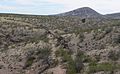 Railroad grade SW of BHBC Byway overpass 8151.JPG 2,178 × 1,345; 830 KB


