Category:Bischofspalais (Eichstätt)
Jump to navigation
Jump to search
| Object location | | View all coordinates using: OpenStreetMap |
|---|
Bishop's palace Eichstätt  | |||||
| Upload media | |||||
| Instance of | |||||
|---|---|---|---|---|---|
| Location | Eichstätt, Upper Bavaria, Bavaria, Germany | ||||
| Street address |
| ||||
| Heritage designation | |||||
 | |||||
This is the category of the Bavarian Baudenkmal (cultural heritage monument) with the ID D-1-76-123-176 (Wikidata)
|
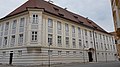
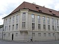
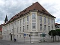
Deutsch: Bischöfliches Palais Eichstätt am Pater-Philipp-Jeningen-Platz 5, mit Front zur Luitpoldstraße: Ehemaliger Domherrenhof Schönborn, zwei- bis dreigeschossige barocke Vierflügelanlage mit rustiziertem Erdgeschoss und mit Eckerker zum Leonrodplatz, nach 1736 von Gabriel de Gabrieli unter Einbeziehung älterer Teile errichtet, 1970/71 durch Karljosef Schattner umgebaut.
Media in category "Bischofspalais (Eichstätt)"
The following 8 files are in this category, out of 8 total.
-
 Bischofspalais Eichstätt -beflaggt.jpg 2,048 × 1,536; 928 KB
-
 Bischöfliches Palais Eichstätt .jpg 4,032 × 2,268; 3.08 MB
-
 Eichstätt - P.-Phil.-Jeningen-Platz 5 - Portal.jpg 3,008 × 2,000; 3.03 MB
-
 Eichstätt, Pater-Philipp-Jeningen-Platz 3-20160816-001.jpg 5,996 × 4,003; 10.73 MB
-
 Pater-Philipp-Jeningen-Platz 3 Eichstaett-2.jpg 2,430 × 1,896; 642 KB
-
 Pater-Philipp-Jeningen-Platz 3 Eichstaett-3.jpg 2,592 × 1,944; 804 KB
-
 Pater-Philipp-Jeningen-Platz 5 Eichstaett-1.jpg 2,556 × 1,905; 647 KB
-
 PP-Jeningen-Platz 3 Eichstätt -Wappen Osttor.jpg 2,048 × 1,536; 1.21 MB


Categories:
- Buildings in Eichstätt
- Cultural heritage monuments in Eichstätt
- Pater-Philipp-Jeningen-Platz (Eichstätt)
- Luitpoldstraße (Eichstätt)
- Roman Catholic Diocese of Eichstätt
- Castles and Residences of the House of Schönborn
- Baroque aristocratic estates in Upper Bavaria
- Buildings by Gabriel de Gabrieli
- Buildings by Karljosef Schattner