Category:Bird's eye view maps of Bristol County, Massachusetts
Jump to navigation
Jump to search
Media in category "Bird's eye view maps of Bristol County, Massachusetts"
The following 23 files are in this category, out of 23 total.
-
 City of Taunton, Mass - G3764.T2A3 1875B3.jpg 10,320 × 7,464; 60.39 MB
-
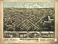
 City of Taunton, Mass. 1875. LOC 74693249.jpg 9,872 × 7,088; 15.62 MB
-
 View of the city of New Bedford, Mass - 1876 G3764.N4A3 1876O43.jpg 10,520 × 6,992; 11.45 MB
-
 City of Fall River, Mass - 1877 G3764.T2A3 1875B3.jpg 10,528 × 6,592; 46.95 MB
-
 City of Fall River, Mass. 1877. LOC 75694571.jpg 13,056 × 8,416; 24.92 MB
-
 Fall River station on 1877 bird's eye map.jpg 605 × 446; 73 KB
-
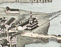
 Fall River Wharf on 1877 bird's eye map.jpg 1,315 × 1,062; 307 KB
-
 Ferry Street station on 1877 bird's eye map.jpg 785 × 587; 119 KB
-
 Watuppa station on 1877 bird's eye map.jpg 483 × 378; 43 KB
-
 North Attleborough, Mass. 1878 (2675787214).jpg 2,000 × 1,673; 3.05 MB
-
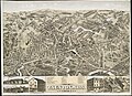
 North Attleborough, Mass. 1878. LOC 75694594.jpg 8,800 × 6,768; 12.08 MB
-
 View of Attleborough, Mass. (2673627193).jpg 2,000 × 1,576; 2.63 MB
-
 View of North Easton, Massachusetts, 1881 (2673667219).jpg 2,000 × 1,555; 2.72 MB
-
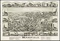
 View of Mansfield, Mass. (2674541320).jpg 2,000 × 1,554; 2.41 MB
-
 View Of North Dighton Village in 1881.jpg 1,024 × 863; 170 KB
-
 View of Somerset, Massachusetts. (2675631272).jpg 2,000 × 1,594; 2.44 MB
-
 Mansfield, Massachusetts (2673720087).jpg 2,000 × 1,364; 2.49 MB
-
 South Easton, Massachusetts (2674488302).jpg 2,000 × 1,662; 3.02 MB
-
 Hebronville, Massachusetts. LOC 90685120.jpg 6,516 × 4,926; 7.06 MB
-
 North Attleborough, Massachusetts (2675095839).jpg 2,000 × 1,495; 2.91 MB
-
 North Easton, Massachusetts (2674483332).jpg 2,000 × 1,517; 2.51 MB
-
 Norton, Massachusetts (2673698271).jpg 2,000 × 1,508; 2.32 MB
-
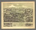
 Norton, Massachusetts 1891. LOC 74693247.jpg 7,968 × 6,048; 7.91 MB


.jpg)

.jpg)
.jpg)
.jpg)

.jpg)
.jpg)
.jpg)

.jpg)
.jpg)
.jpg)
