Category:Biorama-Projekt
Jump to navigation
Jump to search
| Object location | | View all coordinates using: OpenStreetMap |
|---|
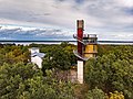
unused historic water tower converted into a private residence  | |||||
| Upload media | |||||
| Instance of | |||||
|---|---|---|---|---|---|
| Made from material | |||||
| Location | Joachimsthal, Barnim District, Brandenburg, Germany | ||||
| Street address |
| ||||
| Heritage designation | |||||
| Height |
| ||||
| official website | |||||
 | |||||
Media in category "Biorama-Projekt"
The following 5 files are in this category, out of 5 total.
-
 2018 09 22 Bioramaturm DJI 0210.jpg 3,999 × 2,995; 4.88 MB
-
 2018 09 22 Grimnitzsee DJI 0214.jpg 4,048 × 3,032; 4.73 MB
-
 Biorama 1.JPG 3,104 × 4,672; 7.33 MB
-
 Joachimsthal Wasserturm 2021.jpg 2,736 × 3,648; 4.63 MB
-
 Wasserturm Joachimsthal.JPG 2,688 × 2,016; 2.02 MB


Categories:
- Buildings in Joachimsthal (Barnim)
- Cultural heritage monuments in Joachimsthal
- Towers in Landkreis Barnim
- Water towers in Brandenburg
- Former water towers
- Observation towers in Brandenburg
- Round towers in Brandenburg
- Brick towers in Brandenburg
- 21-meter-tall buildings in Germany
- Biosphärenreservat Schorfheide-Chorin