Category:Binnenhaven 37, Nieuwpoort
Jump to navigation
Jump to search
| Object location | | View all coordinates using: OpenStreetMap |
|---|
building in Molenwaard, Netherlands  | |||||
| Upload media | |||||
| Instance of | |||||
|---|---|---|---|---|---|
| Location | Nieuwpoort, South Holland, Netherlands | ||||
| Street address |
| ||||
| Located on street |
| ||||
| Heritage designation |
| ||||
 | |||||
|
This is a category about rijksmonument number 30573
|
| Address |
|
Media in category "Binnenhaven 37, Nieuwpoort"
The following 4 files are in this category, out of 4 total.
-
 Aanzicht - Nieuwpoort - 20165778 - RCE.jpg 1,200 × 805; 246 KB
-
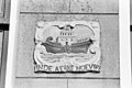 Exterieur GEVELSTEEN - Nieuwpoort - 20266474 - RCE.jpg 1,200 × 800; 213 KB
-
 Nieuwpoort Binnenhaven 37.jpg 2,998 × 4,487; 4.22 MB
-
 RM30573 Nieuwpoort - Binnenhaven 37.jpg 1,944 × 2,592; 1.56 MB


