Category:Bildstock Raaber Kreuz, Laa an der Thaya
Jump to navigation
Jump to search
| This category shows the protected monument with the number 10230 in Austria. (Commons, de, Wikidata) |
 | |||||
| Upload media | |||||
| Instance of | |||||
|---|---|---|---|---|---|
| Location | Laa an der Thaya, Mistelbach District, Lower Austria, Austria | ||||
| Street address |
| ||||
| Heritage designation | |||||
 | |||||
Media in category "Bildstock Raaber Kreuz, Laa an der Thaya"
The following 4 files are in this category, out of 4 total.
-
 Friedhofskapelle 10229 bei A-2136 Laa an der Thaya.jpg 6,000 × 4,000; 5.23 MB
-
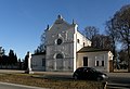 NOE LaaThaya Friedhofskapelle.jpg 3,052 × 2,096; 4.2 MB
-
 NOE LaaThaya RaaberKreuz.jpg 3,264 × 2,176; 2.98 MB
-
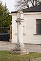 Raaber Kreuz 10230 bei A-2136 Laa an der Thaya.jpg 4,000 × 6,000; 6.06 MB


