Category:Bierkade 5, The Hague
Jump to navigation
Jump to search
| Object location | | View all coordinates using: OpenStreetMap |
|---|
building in The Hague, Netherlands  | |||||
| Upload media | |||||
| Instance of | |||||
|---|---|---|---|---|---|
| Location | The Hague, South Holland, Netherlands | ||||
| Located on street | |||||
| Heritage designation |
| ||||
 | |||||
|
This is a category about rijksmonument number 17461
|
| Address |
|
Media in category "Bierkade 5, The Hague"
The following 11 files are in this category, out of 11 total.
-
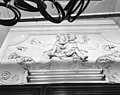 Dessus de porte - 's-Gravenhage - 20088218 - RCE.jpg 1,200 × 948; 162 KB
-
 Interieur achterkamer, schoorsteen - 's-Gravenhage - 20088211 - RCE.jpg 884 × 1,200; 134 KB
-
 Interieur vestibule - 's-Gravenhage - 20088208 - RCE.jpg 886 × 1,200; 132 KB
-
 Interieur vestibule, dessus de porte - 's-Gravenhage - 20088210 - RCE.jpg 890 × 1,200; 139 KB
-
 Interieur vestibule, plafond - 's-Gravenhage - 20088209 - RCE.jpg 878 × 1,200; 131 KB
-
 Plafond - 's-Gravenhage - 20088212 - RCE.jpg 1,200 × 872; 163 KB
-
 Plafond - 's-Gravenhage - 20088213 - RCE.jpg 1,200 × 852; 97 KB
-
 RM17461 Den Haag - Bierkade 5.jpg 2,840 × 2,217; 1.94 MB
-
 Stucplafond in vestibule - 's-Gravenhage - 20088215 - RCE.jpg 958 × 1,200; 181 KB
-
 Stucwerk in hal - 's-Gravenhage - 20088216 - RCE.jpg 958 × 1,200; 155 KB
-
 Stucwerk in hal - 's-Gravenhage - 20088217 - RCE.jpg 958 × 1,200; 148 KB


