Category:Betonschiff von Redentin
Jump to navigation
Jump to search
| Object location | | View all coordinates using: OpenStreetMap |
|---|
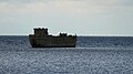
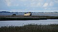
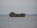
wreck of a motor ship near Wismar, Germany  | |||||
| Upload media | |||||
| Instance of | |||||
|---|---|---|---|---|---|
| Location | Wismar, Nordwestmecklenburg District, Mecklenburg-Western Pomerania, Germany | ||||
| Beam |
| ||||
| Draft |
| ||||
| Length |
| ||||
 | |||||
Media in category "Betonschiff von Redentin"
The following 19 files are in this category, out of 19 total.
-
 2023.09.23.141215 Betonschiff Redentin (Wismar) DE.jpg 3,840 × 2,160; 1.61 MB
-
 2023.09.23.141556 Betonschiff Redentin (Wismar) DE.jpg 3,840 × 2,160; 1.48 MB
-
 2023.09.23.144438 Betonschiff Redentin (Wismar) DE.jpg 3,840 × 2,160; 1.16 MB
-
 2023.09.23.144453 Betonschiff Redentin (Wismar) DE.jpg 3,840 × 2,160; 1.16 MB
-
 Betonboot Redentin 1 2019.jpg 6,720 × 4,480; 7.45 MB
-
 Betonboot Redentin 2 2019.jpg 1,986 × 1,324; 1.75 MB
-
 Betonboot Redentin 3 2019.jpg 4,131 × 2,754; 6.84 MB
-
 Betonschiff Redentin Backbord.jpg 4,032 × 3,024; 5.06 MB
-
 Betonschiff Redentin Bug.jpg 3,024 × 4,032; 4.96 MB
-
 Betonschiff Redentin Captains view.jpg 4,032 × 3,024; 6.17 MB
-
 Betonschiff Redentin Heck.jpg 4,032 × 3,024; 4.73 MB
-
 Betonschiff Redentin Kajüte.jpg 4,032 × 3,024; 5.8 MB
-
 Betonschiff Redentin Laderaum.jpg 4,032 × 3,024; 7.27 MB
-
 Betonschiff Redentin Seite offen.jpg 4,032 × 3,024; 6.88 MB
-
 Betonschiff Redentin Steuerbord.jpg 4,032 × 3,024; 4.87 MB
-
 Betonschiff-Concrete-Ship Redentin rework.JPG 1,918 × 1,314; 478 KB
-
 Betonschiff-Concrete-Ship Redentin.JPG 3,072 × 2,304; 927 KB
-
 Redentin - Betonschiff - 2020.jpg 3,651 × 2,434; 6.22 MB
-
 Wismar 218.jpg 3,872 × 2,592; 2.42 MB
_DE.jpg)
_DE.jpg)
_DE.jpg)
_DE.jpg)


