Category:Bergschild 3, Deventer
Jump to navigation
Jump to search
| Object location | | View all coordinates using: OpenStreetMap |
|---|
 | |||||
| Upload media | |||||
| Instance of |
| ||||
|---|---|---|---|---|---|
| Location | Deventer, Overijssel, Netherlands | ||||
| Street address |
| ||||
| Located on street | |||||
| Heritage designation |
| ||||
 | |||||
|
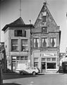
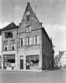
This is a category about rijksmonument number 12426
|
| Address |
|
Media in category "Bergschild 3, Deventer"
The following 7 files are in this category, out of 7 total.
-
 Aanzicht - Deventer - 20055311 - RCE.jpg 2,224 × 3,303; 1.25 MB
-
 Bergschild 3 Deventer.jpg 1,712 × 2,560; 1.11 MB
-
 Voorgevel - Deventer - 20055315 - RCE.jpg 959 × 1,200; 225 KB
-
 Voorgevels - Deventer - 20055310 - RCE.jpg 805 × 1,200; 165 KB
-
 Voorgevels - Deventer - 20055312 - RCE.jpg 953 × 1,200; 237 KB
-
 Voorgevels - Deventer - 20055316 - RCE.jpg 962 × 1,200; 214 KB
-
 Voorgevels met zijgevel - Deventer - 20055313 - RCE.jpg 957 × 1,200; 237 KB


