Category:Benedeneind NZ 414, Benschop
Jump to navigation
Jump to search
| Object location | | View all coordinates using: OpenStreetMap |
|---|
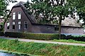
farmhouse in Lopik, Netherlands  | |||||
| Upload media | |||||
| Instance of | |||||
|---|---|---|---|---|---|
| Location | Benschop, Lopik, Utrecht, Netherlands | ||||
| Street address |
| ||||
| Located on street |
| ||||
| Heritage designation |
| ||||
 | |||||
|
This is a category about rijksmonument number 8987
|
| Address |
|
Media in category "Benedeneind NZ 414, Benschop"
The following 2 files are in this category, out of 2 total.
-
 Aanzicht - Benschop - 20030735 - RCE.jpg 1,200 × 811; 304 KB
-
 Benedeneind.NZ414.Benschop.jpg 3,917 × 2,614; 4.35 MB
