Category:Belmont, Unst
Jump to navigation
Jump to search

village on Unst, Shetland Islands, Scotland, UK  Усадьба «Белмонт Хаус» | |||||
| Upload media | |||||
| Instance of | |||||
|---|---|---|---|---|---|
| Location |
| ||||
 | |||||
Subcategories
This category has the following 2 subcategories, out of 2 total.
B
- Belmont House, Shetland Islands (17 F)
L
- Loch of Belmont (20 F)
Media in category "Belmont, Unst"
The following 200 files are in this category, out of 219 total.
(previous page) (next page)-
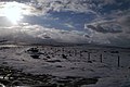
 A twitch at Belmont - geograph.org.uk - 2624331.jpg 800 × 533; 176 KB
-
 A968 near Belmont - geograph.org.uk - 5943427.jpg 800 × 533; 662 KB
-
 An extremely calm sea at Belmont - geograph.org.uk - 5853923.jpg 1,600 × 1,200; 496 KB
-
 Archaeological dig at Belmont - geograph.org.uk - 1379015.jpg 640 × 426; 98 KB
-
 Arrival at Belmont - geograph.org.uk - 3824387.jpg 640 × 480; 260 KB
-
 Arriving at Belmont on Unst - geograph.org.uk - 2097946.jpg 3,264 × 2,448; 1.56 MB
-
 Automatic Weatherstation - geograph.org.uk - 319236.jpg 399 × 600; 35 KB
-
 Ayre of Belmont - geograph.org.uk - 1379000.jpg 640 × 426; 70 KB
-
 Ayre of Belmont - geograph.org.uk - 2186844.jpg 800 × 533; 213 KB
-
 Bales at Belmont - geograph.org.uk - 4633066.jpg 1,024 × 683; 133 KB
-
 Belmont - geograph.org.uk - 1067046.jpg 640 × 426; 70 KB
-
 Belmont - geograph.org.uk - 181384.jpg 640 × 459; 94 KB
-
 Belmont - geograph.org.uk - 321404.jpg 640 × 426; 65 KB
-
 Belmont Farm - geograph.org.uk - 1598033.jpg 640 × 427; 66 KB
-
 Belmont Farm - geograph.org.uk - 4732023.jpg 1,024 × 576; 145 KB
-
 Belmont Farm - geograph.org.uk - 4804557.jpg 1,024 × 682; 160 KB
-
 Belmont ferry - geograph.org.uk - 419158.jpg 640 × 426; 49 KB
-
 Belmont Ferry Pier, Unst - geograph.org.uk - 5922957.jpg 800 × 600; 600 KB
-
 Belmont ferry terminal - geograph.org.uk - 2697023.jpg 1,436 × 1,000; 1.15 MB
-
 Belmont Ferry Terminal - geograph.org.uk - 3927984.jpg 1,280 × 851; 257 KB
-
 Belmont ferry terminal - geograph.org.uk - 53407.jpg 640 × 444; 85 KB
-
 Belmont Ferry Terminal - geograph.org.uk - 5593051.jpg 3,648 × 2,736; 3.47 MB
-
 Belmont ferry terminal - geograph.org.uk - 6006560.jpg 1,600 × 900; 459 KB
-
 Belmont Ferry Terminal, Unst - geograph.org.uk - 5922945.jpg 800 × 600; 469 KB
-
 Belmont ferry, Unst - geograph.org.uk - 335477.jpg 640 × 440; 50 KB
-
 Belmont from above Loch of Belmont - geograph.org.uk - 736040.jpg 640 × 426; 54 KB
-
 Belmont from Gallow Hill - geograph.org.uk - 3136695.jpg 1,024 × 682; 125 KB
-
 Belmont from Snarravoe - geograph.org.uk - 3253625.jpg 1,024 × 681; 141 KB
-
 Belmont from the Ferry - geograph.org.uk - 5850683.jpg 5,000 × 3,333; 5.91 MB
-
 Belmont from the sea - geograph.org.uk - 2205511.jpg 800 × 534; 162 KB
-
 Belmont from the track to Mula - geograph.org.uk - 5468717.jpg 1,600 × 1,065; 346 KB
-
 Belmont House - geograph.org.uk - 1863048.jpg 800 × 534; 172 KB
-
 Belmont House - geograph.org.uk - 2624349.jpg 534 × 800; 176 KB
-
 Belmont House - geograph.org.uk - 3616559.jpg 1,024 × 681; 153 KB
-

-
 Belmont House from the sea - geograph.org.uk - 2205505.jpg 800 × 534; 182 KB
-
 Belmont House from the sea - geograph.org.uk - 3921900.jpg 1,024 × 681; 120 KB
-
 Belmont House from the sea - geograph.org.uk - 4763363.jpg 1,024 × 682; 98 KB
-
 Belmont House on a late afternoon in winter - geograph.org.uk - 2683570.jpg 1,024 × 682; 161 KB
-
 Belmont longhouse - geograph.org.uk - 858451.jpg 640 × 426; 107 KB
-
 Belmont pier - geograph.org.uk - 3566757.jpg 640 × 480; 309 KB
-
 Belmont pier - geograph.org.uk - 3817340.jpg 640 × 480; 240 KB
-
 Belmont pier - geograph.org.uk - 3817345.jpg 640 × 410; 196 KB
-
 Belmont Pier Quarry - geograph.org.uk - 222551.jpg 640 × 480; 76 KB
-
 Belmont, double-decker café - geograph.org.uk - 3558433.jpg 640 × 480; 87 KB
-
 Belmont, ferry arriving - geograph.org.uk - 2651193.jpg 640 × 480; 62 KB
-
 Belmont, ferry terminal - geograph.org.uk - 2651191.jpg 640 × 480; 64 KB
-
 Belmont, welcome to Unst - geograph.org.uk - 2538919.jpg 640 × 480; 73 KB
-
 Bluemull Sound - geograph.org.uk - 1205985.jpg 640 × 426; 67 KB
-
 Bluemull Sound ferry and the Blue Mull - geograph.org.uk - 3477966.jpg 1,024 × 684; 97 KB
-
 Bluemull Sound ferry terminal, Unst - geograph.org.uk - 957547.jpg 640 × 480; 57 KB
-
 Braeside, Belmont - geograph.org.uk - 3253324.jpg 1,024 × 681; 186 KB
-
 Breakwater, Belmont - geograph.org.uk - 3824384.jpg 640 × 480; 231 KB
-
 Breimires - geograph.org.uk - 719472.jpg 640 × 426; 98 KB
-
 Broch at Hoga Ness, Belmont - geograph.org.uk - 3541873.jpg 1,024 × 681; 191 KB
-
 Burn flowing into the Burn of Breimires - geograph.org.uk - 719464.jpg 640 × 426; 121 KB
-
 Burn of Breimires - geograph.org.uk - 719493.jpg 640 × 426; 130 KB
-
 Bus Cafe - geograph.org.uk - 3567402.jpg 2,560 × 1,920; 2.49 MB
-
 Bushes beside Wester Loch, Uyeasound - geograph.org.uk - 1509502.jpg 640 × 426; 104 KB
-
 Cattle Grid on the A968 near Belmont - geograph.org.uk - 5943424.jpg 800 × 533; 495 KB
-
 Cliffs at Blue Mull - geograph.org.uk - 597174.jpg 640 × 426; 102 KB
-
 Cliffs at Bluemull - geograph.org.uk - 597182.jpg 640 × 426; 110 KB
-
 Cliffs south of Blue Mull - geograph.org.uk - 597186.jpg 640 × 426; 107 KB
-
 Coarse pebble beach - geograph.org.uk - 719427.jpg 640 × 426; 106 KB
-
-
 Coast near Belmont - geograph.org.uk - 4633334.jpg 5,184 × 3,456; 3.81 MB
-
 Coast north of Doogers, near Belmont - geograph.org.uk - 3541884.jpg 1,024 × 681; 208 KB
-
 Coastline between Belmont and Mula Head - geograph.org.uk - 5264476.jpg 1,600 × 900; 369 KB
-
 Common Seal (Phoca vitulina), Snarra Voe (geograph 3541893).jpg 1,024 × 681; 223 KB
-
 Corn stooks at Belmont - geograph.org.uk - 4732009.jpg 1,024 × 576; 98 KB
-
 Cotton Grass at Braeside - geograph.org.uk - 4638448.jpg 5,184 × 3,456; 3.41 MB
-
 Cow at Belmont - geograph.org.uk - 4902838.jpg 682 × 1,024; 159 KB
-
 Cranes and lighthouse - geograph.org.uk - 775808.jpg 640 × 426; 296 KB
-
 Drystone dyke - geograph.org.uk - 319194.jpg 399 × 600; 94 KB
-
 Dyke at Heogland - geograph.org.uk - 426042.jpg 426 × 640; 97 KB
-
 Edge of Sobul - geograph.org.uk - 347154.jpg 426 × 640; 51 KB
-
 Eider and ducklings, Belmont - geograph.org.uk - 3541865.jpg 1,024 × 665; 195 KB
-
 Electricity cables at Gorsendi Geo, Belmont - geograph.org.uk - 3253401.jpg 1,024 × 681; 160 KB
-
 Erosion - geograph.org.uk - 564148.jpg 640 × 426; 82 KB
-
 Fence - geograph.org.uk - 319205.jpg 600 × 399; 38 KB
-
 Ferry approaching Belmont - geograph.org.uk - 2624336.jpg 800 × 534; 181 KB
-
 Ferry arriving at Belmont - geograph.org.uk - 3541868.jpg 1,024 × 682; 192 KB
-
 Ferry holding area at Belmont - geograph.org.uk - 3470116.jpg 640 × 480; 86 KB
-
 Ferry loading at Belmont - geograph.org.uk - 5468694.jpg 1,600 × 1,065; 438 KB
-
 Ferry pier at Belmont - geograph.org.uk - 3981985.jpg 2,048 × 1,536; 982 KB
-
 Ferry Pier at Belmont - geograph.org.uk - 5922956.jpg 800 × 600; 686 KB
-
 Ferry queue at Belmont - geograph.org.uk - 3541863.jpg 1,024 × 681; 183 KB
-
 Ferry service suspended, Belmont - geograph.org.uk - 1194614.jpg 640 × 426; 85 KB
-
 First sight of Unst - geograph.org.uk - 957544.jpg 640 × 480; 59 KB
-
 Fish cages in Wick of Belmont - geograph.org.uk - 2698465.jpg 1,557 × 1,000; 1.04 MB
-
 Fish farm at Belmont - geograph.org.uk - 1070780.jpg 640 × 426; 87 KB
-
 Fish farm at Belmont - geograph.org.uk - 1378992.jpg 640 × 426; 64 KB
-
 Fish farm in the Wick of Belmont - geograph.org.uk - 3513296.jpg 640 × 480; 56 KB
-
 Fish farm, Belmont - geograph.org.uk - 1598043.jpg 640 × 426; 53 KB
-
 Fish plant off Belmont, Unst - geograph.org.uk - 5850524.jpg 5,184 × 3,456; 5.07 MB
-

-
 FIVLA arriving at Belmont - geograph.org.uk - 3271548.jpg 640 × 480; 48 KB
-
 Floating hut, Belmont - geograph.org.uk - 3824379.jpg 640 × 480; 209 KB
-
 Floating shed at Belmont - geograph.org.uk - 3114770.jpg 1,024 × 681; 125 KB
-
 Gallow Hill - geograph.org.uk - 426077.jpg 640 × 426; 58 KB
-
 Gallow Hill pool - geograph.org.uk - 434485.jpg 640 × 426; 53 KB
-
 Glaucous Gull (Larus hyperboreus) - geograph.org.uk - 600036.jpg 640 × 426; 56 KB
-
 Gorsendi Geo, Belmont - geograph.org.uk - 3253397.jpg 1,024 × 682; 182 KB
-
 Gorsendi Geo, Belmont - geograph.org.uk - 3253405.jpg 1,024 × 681; 231 KB
-
 Gorsendi Geo, Belmont - geograph.org.uk - 3253408.jpg 1,024 × 681; 121 KB
-
 Gulls, Wick of Belmont - geograph.org.uk - 4633051.jpg 5,184 × 3,456; 2.46 MB
-
 Head of Mula - geograph.org.uk - 3825653.jpg 640 × 260; 114 KB
-
 Heogland - geograph.org.uk - 426027.jpg 640 × 414; 38 KB
-
 Heogland storm beach - geograph.org.uk - 426058.jpg 640 × 426; 48 KB
-
 Herring Gull (Larus argentatus), Belmont - geograph.org.uk - 3780681.jpg 1,024 × 680; 145 KB
-
 Hoga Ness - geograph.org.uk - 3116155.jpg 1,024 × 683; 246 KB
-
 Hoga Ness in the snow - geograph.org.uk - 2205517.jpg 640 × 427; 68 KB
-
 Hoganess - geograph.org.uk - 3505630.jpg 640 × 480; 61 KB
-
 Hoganess, Belmont - geograph.org.uk - 3253308.jpg 1,024 × 681; 205 KB
-
 House at Belmont - geograph.org.uk - 4763356.jpg 682 × 1,024; 150 KB
-
 Houses at Belmont - geograph.org.uk - 1613781.jpg 640 × 427; 51 KB
-
 Houses at Belmont - geograph.org.uk - 4763354.jpg 1,024 × 682; 123 KB
-
 Houses at Belmont - geograph.org.uk - 5123471.jpg 1,024 × 682; 134 KB
-
 Killer Whale (Orca orcinus) in Bluemull Sound - geograph.org.uk - 5847298.jpg 1,600 × 1,067; 525 KB
-

-
 Leaving Belmont ferry terminal - geograph.org.uk - 95337.jpg 640 × 401; 111 KB
-
 Littlegarth - geograph.org.uk - 335577.jpg 640 × 426; 19 KB
-
 Loch of Snarravoe - geograph.org.uk - 319191.jpg 600 × 399; 63 KB
-
 Loch of Snarravoe and Belmont - geograph.org.uk - 4263663.jpg 1,024 × 681; 114 KB
-
 Lund - geograph.org.uk - 347151.jpg 640 × 426; 44 KB
-
 Lund - geograph.org.uk - 446290.jpg 640 × 426; 85 KB
-

-
 Midland Red at Belmont Pier - geograph.org.uk - 3759411.jpg 800 × 436; 63 KB
-
 Mires of Ramnageo - geograph.org.uk - 319164.jpg 600 × 399; 57 KB
-
 Mussel Farm, Wick of Belmont - geograph.org.uk - 5922955.jpg 800 × 600; 589 KB
-
-
 MV Bigga approaching Belmont ferry terminal (geograph 5853922).jpg 1,600 × 1,200; 556 KB
-
 MV Bigga at Belmont on Unst - geograph.org.uk - 5812819.jpg 1,024 × 570; 147 KB
-
 MV Fivla coming in to the pier at Belmont - geograph.org.uk - 3114762.jpg 1,024 × 681; 120 KB
-
 MV Island Senior at Belmont - geograph.org.uk - 3888866.jpg 1,024 × 681; 110 KB
-
 MV Thora at Belmont - geograph.org.uk - 3369760.jpg 1,024 × 681; 174 KB
-
 North slope of Caldback Hill - geograph.org.uk - 335581.jpg 640 × 426; 52 KB
-
 Noust of Mula - geograph.org.uk - 5264481.jpg 1,600 × 900; 331 KB
-
 Noust of Mula, between Belmont and Heogland - geograph.org.uk - 3779165.jpg 1,024 × 577; 163 KB
-

-
 Outer wall of Hoga Ness broch, Belmont - geograph.org.uk - 3253304.jpg 1,024 × 681; 184 KB
-
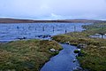 Outflow from Loch of Belmont - geograph.org.uk - 3253301.jpg 1,024 × 681; 169 KB
-
-
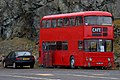 Pie in the Sky, the cafe in a bus at Belmont - geograph.org.uk - 3421580.jpg 1,024 × 681; 208 KB
-
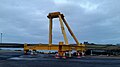
 Pier reinforcement - geograph.org.uk - 6707537.jpg 1,024 × 768; 458 KB
-
 Ploughing at Belmont - geograph.org.uk - 4919406.jpg 1,024 × 681; 199 KB
-
 Risso's Dolphins (Grampus griseus) at Belmont - geograph.org.uk - 6155064.jpg 1,600 × 1,068; 399 KB
-

-
 Sailing at Lake Macquarie (2886372380).jpg 589 × 410; 51 KB
-
 Salmon boat at the Belmont cages - geograph.org.uk - 4224398.jpg 1,024 × 681; 157 KB
-
 Salmon cages at Belmont - geograph.org.uk - 2477087.jpg 800 × 533; 197 KB
-
 Salmon cages off Head of Mula - geograph.org.uk - 3824377.jpg 640 × 480; 209 KB
-
 Scorda Skerry, Head of Mula, Belmont - geograph.org.uk - 3779161.jpg 1,024 × 577; 169 KB
-
 Shag (Phalacrocorax aristotelis), Belmont - geograph.org.uk - 3812991.jpg 1,024 × 1,023; 217 KB
-

-
 Shetland pony and foal at Belmont - geograph.org.uk - 2425495.jpg 532 × 800; 143 KB
-
 Shingle beach at Westing, Unst - geograph.org.uk - 335495.jpg 640 × 438; 66 KB
-
 Shore Hill from Gallow Hill - geograph.org.uk - 434500.jpg 640 × 426; 57 KB
-
 Sign and musical boat, Belmont - geograph.org.uk - 1598057.jpg 640 × 427; 72 KB
-
 Small Pier at Belmont - geograph.org.uk - 5922948.jpg 800 × 600; 619 KB
-
 Small Waters - geograph.org.uk - 321997.jpg 399 × 600; 41 KB
-
 Snarravoe - geograph.org.uk - 531318.jpg 426 × 640; 82 KB
-
 South end of the Valla Field ridge - geograph.org.uk - 519219.jpg 640 × 426; 64 KB
-
 Stooks and stubble at Belmont - geograph.org.uk - 2624343.jpg 800 × 534; 194 KB
-
 Storm beach - geograph.org.uk - 663020.jpg 640 × 427; 101 KB
-
 Summit of Gallow Hill - geograph.org.uk - 434489.jpg 640 × 426; 64 KB
-
 Sunset at Belmont - geograph.org.uk - 2624352.jpg 800 × 533; 101 KB
-
 The 'Plinky Boat' at Belmont - geograph.org.uk - 2683595.jpg 1,024 × 682; 174 KB
-
 The A968 near Caldback, heading for Belmont - geograph.org.uk - 5010939.jpg 2,592 × 1,944; 1.76 MB
-
 The ferry from Gutcher (on the island of Yell) approaches - geograph.org.uk - 5010985.jpg 2,592 × 1,944; 1.51 MB
-
 The house at Hoga Ness, Belmont - geograph.org.uk - 5123475.jpg 1,024 × 682; 173 KB
-
 The lighthouse at Mula, Belmont - geograph.org.uk - 5468818.jpg 1,024 × 682; 138 KB
-
 The lighthouse at Mula, Belmont - geograph.org.uk - 5468826.jpg 1,024 × 682; 148 KB
-
 The pier at Belmont - geograph.org.uk - 3116152.jpg 1,024 × 683; 204 KB
-

-
 The Unstfest Puffin 'Grace' at Belmont - geograph.org.uk - 5468689.jpg 1,600 × 1,065; 470 KB
-
 The Unstfest Puffin 'Mula' at Belmont - geograph.org.uk - 5468832.jpg 1,600 × 1,065; 550 KB
-
 The White Wife - geograph.org.uk - 305787.jpg 390 × 600; 63 KB
-
 Transferring salmon, Belmont - geograph.org.uk - 1598041.jpg 640 × 426; 49 KB
-
 Transitory waterfall, Belmont - geograph.org.uk - 992362.jpg 426 × 640; 123 KB
-
 Unsafe Pier, Belmont - geograph.org.uk - 4633061.jpg 4,000 × 2,664; 2.15 MB
-
 Upstairs in "Pie in the sky" - geograph.org.uk - 3513311.jpg 640 × 480; 80 KB
-
 Vessels, Belmont - geograph.org.uk - 1071092.jpg 640 × 426; 81 KB
-
 View from Braeside - geograph.org.uk - 4638331.jpg 3,852 × 2,148; 1.49 MB
-
 View to Bluemull from Belmont - geograph.org.uk - 2149073.jpg 800 × 533; 226 KB
-

-
 Viktoria Viking at Belmont - geograph.org.uk - 3470458.jpg 1,024 × 618; 122 KB
-

-
 Welcome to Unst (1) - geograph.org.uk - 5922937.jpg 800 × 600; 577 KB
-
 Welcome to Unst (2) - geograph.org.uk - 5922940.jpg 800 × 600; 652 KB
-
 Welcome to Unst - geograph.org.uk - 1309126.jpg 640 × 481; 75 KB
-
 Welcome to Unst - geograph.org.uk - 3927958.jpg 1,280 × 851; 310 KB
-
 White rock of Vatnagarth - geograph.org.uk - 436106.jpg 640 × 480; 131 KB
-
 Wick of Belmont - geograph.org.uk - 5010972.jpg 2,592 × 1,944; 1.62 MB
-
 Wick of Belmont from above Hoga Ness - geograph.org.uk - 2196195.jpg 800 × 532; 123 KB
-
 Working on the salmon cages at Belmont - geograph.org.uk - 5611962.jpg 1,024 × 682; 133 KB
-
 Abandoned sheep pund - geograph.org.uk - 719538.jpg 640 × 426; 106 KB
-
 Ayre of Heogland - geograph.org.uk - 426036.jpg 640 × 414; 77 KB
-
-
 Belmont from the south - geograph.org.uk - 425997.jpg 640 × 426; 51 KB


,_Snarra_Voe_(geograph_3541893).jpg)


_-_geograph.org.uk_-_600036.jpg)


,_Belmont_-_geograph.org.uk_-_3780681.jpg)


_in_Bluemull_Sound_-_geograph.org.uk_-_5847298.jpg)
,_passing_the_ferry_MV_Bigga_in_Bluemull_Sound_-_geograph.org.uk_-_6555176.jpg)


,_Belmont_-_geograph.org.uk_-_1379029.jpg)


_at_Belmont_-_geograph.org.uk_-_6155062.jpg)
.jpg)


_at_Belmont_-_geograph.org.uk_-_6155064.jpg)
,_near_Belmont_-_geograph.org.uk_-_1590767.jpg)
.jpg)


,_Belmont_-_geograph.org.uk_-_3812991.jpg)
_at_Doogers,_near_Belmont_-_geograph.org.uk_-_3541878.jpg)


_approaches_-_geograph.org.uk_-_5010985.jpg)


_-_geograph.org.uk_-_5922937.jpg)
_-_geograph.org.uk_-_5922940.jpg)


