Category:Beinn Dubhchraig
Jump to navigation
Jump to search
978m high mountain in Stirling, Scotland, UK  | |||||
| Upload media | |||||
| Instance of | |||||
|---|---|---|---|---|---|
| Location | Stirling, Scotland | ||||
| Mountain range | |||||
| Topographic prominence |
| ||||
| Elevation above sea level |
| ||||
| Parent peak | |||||
 | |||||
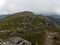
Beinn Dubhchraig is a mountain in the southern highlands of Scotland. It is located about 8 km west of Crianlarich, in the northern part of the Loch Lomond and the Trossachs National Park. It is 978 m high, and listed as a Munro and a Marilyn.
Media in category "Beinn Dubhchraig"
The following 16 files are in this category, out of 16 total.
-
 Allt Coire Dubhchraig - geograph.org.uk - 219302.jpg 478 × 640; 176 KB
-

-
 Beinn Dubhchraig - geograph.org.uk - 219295.jpg 640 × 478; 113 KB
-
 Beinn Dubhchraig - geograph.org.uk - 562295.jpg 640 × 409; 58 KB
-

-
 Ben Dubhchraig from Ben Oss.jpg 1,291 × 920; 113 KB
-
 Leaving Beinn Dubhchraig - geograph.org.uk - 1018018.jpg 640 × 415; 73 KB
-
 Lochan a' Chaisteil - geograph.org.uk - 1008733.jpg 640 × 421; 89 KB
-
 View from Beinn Dubhchraig - geograph.org.uk - 219301.jpg 640 × 478; 97 KB
-
 View North from summit of Ben Vane. - geograph.org.uk - 940113.jpg 640 × 435; 62 KB
-
 Allt Gleann Auchreoch - geograph.org.uk - 1143956.jpg 640 × 469; 104 KB
-
 Beinn Dubhchraig , Munro No 175 - geograph.org.uk - 75512.jpg 640 × 480; 144 KB
-
 Loch Oss - geograph.org.uk - 219277.jpg 640 × 478; 143 KB
-
 Loch Oss - geograph.org.uk - 219287.jpg 640 × 478; 131 KB
-
 The eastern flank of Beinn Dubhchraig - geograph.org.uk - 219300.jpg 640 × 478; 117 KB
-
 The summit of Beinn Dubhchraig - geograph.org.uk - 86888.jpg 640 × 457; 110 KB


