Category:Begijnengang (Venlo)
Jump to navigation
Jump to search
street in Venlo, the Netherlands | |||||
| Upload media | |||||
| Instance of | |||||
|---|---|---|---|---|---|
| Location | Venlo, Limburg, Netherlands | ||||
 | |||||
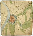
De Begijnengang in Venlo is een verbindingsstraat in de oude binnenstad in de buurt het Kloosterkwartier. Het loopt in het noord-zuid vanaf de kruising Gasthuisstraat, Sint Jorisstraat, Grote Kerkstraat en Parade tot de Klaasstraat, waarna het verder gaat als de Nieuwstraat.
Media in category "Begijnengang (Venlo)"
The following 5 files are in this category, out of 5 total.
-
 1560 Kaart van Venlo door Jacob van Deventer.jpg 3,672 × 3,904; 3.87 MB
-
 1811-1832 Kadastrale kaart 1811-1832 minuutplan Venlo, Limburg, sectie I, blad 01.jpg 8,943 × 7,630; 13.69 MB
-

-

-
 1930 De Gasthuisstraat. Gezien vanaf de Parade richting de Markt.jpg 703 × 1,106; 171 KB


