Category:Bayarti House (Musrara)
Jump to navigation
Jump to search
| Object location | | View all coordinates using: OpenStreetMap |
|---|
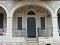
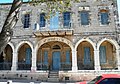
English: The historical building on 9, Ha'ain Het st. in Musrara was the house of the lebanese family Bayarti. After the 1948 war, the building was turned into an ultra orthodox Jewish school (Beit Yaakov) for the children of the neighborhood - whose parents were mostly immigrants from north Africa. The school closed at the end of the 1960s and is now the home of the Naggar school of photography in Musrara.
עברית: מבנה בשכונה, Original Image Name:שכונת מוסררה - מורשה בירושלים, Location:ירושלים Jerusalem
 | |||||
| Upload media | |||||
| Instance of | |||||
|---|---|---|---|---|---|
| Location | Jerusalem, Quds Governorate, West Bank | ||||
| Located on street | |||||
| Inception |
| ||||
| official website | |||||
 | |||||
Media in category "Bayarti House (Musrara)"
The following 18 files are in this category, out of 18 total.
-
 Jerusalem Musrara Bayarti House gate.jpg 4,000 × 3,000; 4.51 MB
-
 Jerusalem Musrara Bayarti House view from Natan HaNavi St.jpg 4,000 × 3,000; 5.16 MB
-
 Musrara 2.JPG 4,158 × 2,910; 2.9 MB
-
 Musrara 6.JPG 4,288 × 3,216; 2.8 MB
-
 Musrara P1010079.JPG 4,000 × 3,000; 5 MB
-
 Musrara P1010080.JPG 3,000 × 4,000; 4.33 MB
-
 Musrara P1010085.JPG 4,000 × 3,000; 5.11 MB
-
 Musrara P1010086.JPG 3,000 × 4,000; 3.97 MB
-
 Musrara P1010089.JPG 4,000 × 3,000; 4.69 MB
-
 Musrara School.jpg 2,480 × 1,653; 1.71 MB
-
 Naggar School 022.jpg 5,184 × 2,912; 5.3 MB
-
 Naggar School 023.jpg 5,184 × 2,912; 5.13 MB
-
 Naggar School 024.jpg 5,184 × 2,912; 5.1 MB
-
 Naggar School 025.jpg 5,184 × 2,912; 4.87 MB
-
 Naggar School 026.jpg 3,456 × 5,184; 9.34 MB
-
 Naggar School 027.jpg 3,202 × 5,121; 10.97 MB
-
 Naggar School 028.jpg 5,184 × 3,456; 4.9 MB
-
 PikiWiki Israel 22106 Architecture of Israel.JPG 2,592 × 1,757; 1.04 MB


