Category:Bay Tree Farm, Frankby
Jump to navigation
Jump to search
| Object location | | View all coordinates using: OpenStreetMap |
|---|
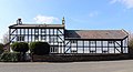
Farm buildings opposite Hill Bark Road and the entrance to Frankby Cemetery.
Media in category "Bay Tree Farm, Frankby"
The following 3 files are in this category, out of 3 total.
-
 Bay Tree Farm, Frankby.jpg 4,594 × 2,502; 8.63 MB
-
 Datestone, Bay Tree Farm, Frankby.jpg 4,404 × 3,375; 10.04 MB
-
 Timber-framed house, Frankby Village.JPG 4,320 × 3,240; 3.05 MB


