Category:Baxter State Park
Jump to navigation
Jump to search
state park in Maine, USA  | |||||
| Upload media | |||||
| Instance of | |||||
|---|---|---|---|---|---|
| Location | Piscataquis County, Maine | ||||
| IUCN protected areas category | |||||
| Inception |
| ||||
| Highest point | |||||
| Area |
| ||||
| official website | |||||
 | |||||
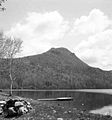
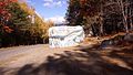
Deutsch: Der Baxter State Park ist ein großes Wildnisgebiet, der dauerhaft als State Park geschützt wird. Er liegt im Piscataquis County im nördlichen Zentralmaine. Er wurde 1931 errichtet und vergrößerte seine Fläche auf über 800 km². Im Park liegt auch der höchste Berg Maines, der Katahdin.
English: Baxter State Park is a large wilderness area permanently preserved as a state park, located in Piscataquis County in north-central Maine. It was established in 1931, and has grown to over 200,000 acres (800 km²) in size. The park is home to the state's highest peak, Katahdin.
Subcategories
This category has the following 3 subcategories, out of 3 total.
H
M
T
Media in category "Baxter State Park"
The following 9 files are in this category, out of 9 total.
-
 Baxter State Park.jpg 1,960 × 4,032; 4.28 MB
-
 ChimneyPondLT.jpg 1,296 × 976; 776 KB
-
 Entering Baxter State Park.jpg 3,456 × 2,304; 4.47 MB
-
 Katahdin Stream Campground - panoramio.jpg 2,816 × 2,112; 2.21 MB
-
 Katahdin Stream Falls - panoramio.jpg 2,816 × 2,112; 2.41 MB
-
 Lake in Baxter State Park - panoramio.jpg 2,816 × 2,112; 1.8 MB
-
 Little Niagra, Canada 8531.jpg 2,230 × 1,752; 3.86 MB
-
 North Traveller Ridge from Baxter Park campsite.jpg 640 × 684; 31 KB
-
 Pockwockamus Rock.jpg 4,608 × 2,592; 2.2 MB


