Category:Bauernhaus, Villmergen
Jump to navigation
Jump to search
| Object location | | View all coordinates using: OpenStreetMap |
|---|
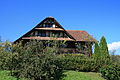
farmhouse in Villmergen in the canton of Aargau, Switzerland  | |||||
| Upload media | |||||
| Instance of | |||||
|---|---|---|---|---|---|
| Part of | |||||
| Location | Villmergen, Bremgarten District, Aargau, Switzerland | ||||
| Street address |
| ||||
| Heritage designation | |||||
| Inception |
| ||||
 | |||||
Media in category "Bauernhaus, Villmergen"
The following 5 files are in this category, out of 5 total.
-
 Villmergen Bauernhaus KGS 9900 2012-09-28 01.jpg 3,888 × 2,592; 5.61 MB
-
 Villmergen Bauernhaus KGS 9900 2012-09-28 02.jpg 3,888 × 2,592; 5.68 MB
-
 Villmergen Bauernhaus KGS 9900 2012-09-28 03.jpg 3,888 × 2,592; 4.21 MB
-
 Villmergen Bauernhaus KGS 9900 2012-09-28 04.jpg 3,888 × 2,592; 3.98 MB
-
 Villmergen Bauernhaus KGS 9900 2012-09-28 05.jpg 3,888 × 2,592; 2.78 MB


