Category:Barnston Dale
Jump to navigation
Jump to search
| Object location | | View all coordinates using: OpenStreetMap |
|---|
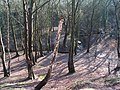
Barnston Dale is a wooded valley to the north of Barnston village, Wirral. Prenton Brook and the A551 both pass through it.
Subcategories
This category has the following 3 subcategories, out of 3 total.
B
- Barnston Dale bridge (8 F)
P
Media in category "Barnston Dale"
The following 6 files are in this category, out of 6 total.
-
 Barnston Dale - geograph.org.uk - 341597.jpg 640 × 480; 116 KB
-
 Barnston Dale 2019-1.jpg 5,202 × 3,468; 18.93 MB
-
 Barnston Dale 2019-2.jpg 5,178 × 3,452; 18.02 MB
-
 Barnston Dale 2019-3.jpg 4,608 × 3,456; 19.06 MB
-
 Barnston Dale 2019-4.jpg 5,292 × 3,528; 23.51 MB
-
 Benchmark in Barnston Dale near Gills Lane.jpg 3,048 × 4,224; 8.39 MB


