Category:Barcoo River
Jump to navigation
Jump to search
Deutsch: Der Barcoo River ist ein Fluss im Westen des australischen Bundesstaates Queensland. Bei Windorah mündet der Thomson River, wodurch der Barcoo River zum Coopers Creek, einem der längsten Flüsse Australiens, wird. (→Barcoo River)
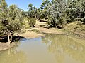
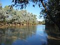
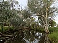
English: The Barcoo River in western Queensland, Australia that rises on the northern slopes of the Warrego Range, flows in a south westerly direction and unites with the Thomson River to form Cooper Creek. The first European to see the river was Thomas Mitchell in 1846, who named it Victoria Stream. It was renamed by Edmund Kennedy after a name supplied by local Aborigines. (→Barcoo River)
Español: El río Barcoo es un largo río de Australia que discurre por el oeste del estado de Queensland. Nace al norte de las montañas Warrego y se une con el río Thomson para formar el río Cooper (o arroyo). Fue descubierto por Thomas Mitchell en 1846 y recibió su nombre de Victoria, nombre cambiado posteriormente por Edmund Kennedy para retomar el nombre aborigen. (→Barcoo)
Français : La Barcoo River est une rivière endoréique de l'ouest du Queensland en Australie. (→Barcoo River)
Norsk bokmål: Barcoo er ei elv i det vestlige Queensland i Australia. Den har utspring på vesthellingen av Warregofjellene, i den nordlige delen av Great Dividing Range, i området ved Barcaldine, rundt 500 kilometer inn i landet fra byen Rockhampton. Ved samløpet med elva Thomson nord for byen Windorah danner den Cooper Creek. (→Barcoo (elv))
Português: O Rio Barcoo é um rio da Austrália, afluente do Cooper Creek, localizado no estado de Queensland. (→Rio Barcoo)
river in Queensland, Australia  | |||||
| Upload media | |||||
| Instance of | |||||
|---|---|---|---|---|---|
| Location | South Australia, AUS | ||||
| Length |
| ||||
| Mouth of the watercourse | |||||
| Drainage basin |
| ||||
| Tributary | |||||
 | |||||
Media in category "Barcoo River"
The following 17 files are in this category, out of 17 total.
-
 Barcoo River from Isisford Bridge, Queensland, 2024, 01.jpg 4,032 × 3,024; 4.39 MB
-
 Barcoo River from Isisford Bridge, Queensland, 2024, 02.jpg 8,064 × 6,048; 12.92 MB
-
 Barcoo River from Isisford Bridge, Queensland, 2024, 03.jpg 4,032 × 3,024; 4.22 MB
-
 Barcoo River Isisford.jpg 3,264 × 2,448; 5.04 MB
-
 Barcoo River, Queensland.jpg 931 × 634; 168 KB
-
 Barcoo river, Tambo.JPG 3,264 × 2,448; 4.41 MB
-
 Isisford Bridge over Barcoo River, Queensland, 2024, 01.jpg 7,581 × 5,686; 14.99 MB
-
 Isisford Bridge over Barcoo River, Queensland, 2024, 02.jpg 8,064 × 6,048; 10.89 MB
-
 Isisford Bridge over Barcoo River, Queensland, 2024, 03.jpg 5,987 × 5,968; 6.65 MB
-
 Isisford Bridge over Barcoo River, Queensland, 2024, 04.jpg 6,042 × 6,015; 7.17 MB
-

-
 StateLibQld 1 101164.jpg 1,000 × 768; 82 KB
-

-
 StateLibQld 1 137300 Tanbar Station, November, 1939.jpg 1,000 × 724; 104 KB
-
 StateLibQld 1 153023 Record Blackall Flood in 1906.jpg 1,000 × 608; 46 KB
-
 StateLibQld 1 154223 Blackall's main traffic bridge under water, 1933.jpg 1,000 × 702; 131 KB
-


