Category:Balthasar-Neumann-Straße 5 (Wiesentheid)
Jump to navigation
Jump to search
This is the category of the Bavarian Baudenkmal (cultural heritage monument) with the ID D-6-75-178-12 (Wikidata)
|
| Object location | | View all coordinates using: OpenStreetMap |
|---|
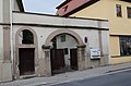
Deutsch: Wohnhaus. Zweigeschossiger Walmdachbau mit geohrten Fenstern im Obergeschoss, bezeichnet „1770“. Toreinfahrt, rundbogig, bezeichnet „1812“. Balthasar-Neumann-Straße 5, Wiesentheid, Landkreis Kitzingen, Unterfranken, Deutschland.
cultural heritage monument D-6-75-178-12 (0) in Wiesentheid, Bavaria  | |||||
| Upload media | |||||
| Instance of | |||||
|---|---|---|---|---|---|
| Location | Wiesentheid, Kitzingen, Lower Franconia, Bavaria, Germany | ||||
| Street address |
| ||||
| Has part(s) |
| ||||
| Heritage designation | |||||
 | |||||
Media in category "Balthasar-Neumann-Straße 5 (Wiesentheid)"
The following 8 files are in this category, out of 8 total.
-
 1 Balthasar-Neumann-Straße 5 Wiesentheid 1.jpg 3,872 × 2,592; 4.62 MB
-
 Balthasar-Neumann-Straße 26 Wiesentheid 20200522 001.jpg 6,016 × 4,016; 9.81 MB
-
 Balthasar-Neumann-Straße 26 Wiesentheid 20200522 002.jpg 6,016 × 4,016; 9.48 MB
-
 Balthasar-Neumann-Straße 5 Wiesentheid 20200522 001.jpg 6,016 × 4,016; 9.12 MB
-
 Balthasar-Neumann-Straße 5 Wiesentheid 20200522 002.jpg 6,016 × 4,016; 9.29 MB
-
 Balthasar-Neumann-Straße 5 Wiesentheid 20200522 003.jpg 6,016 × 4,016; 9.17 MB
-
 Wiesentheid, Balthasar-Neumann-Straße 5, 001.jpg 4,928 × 3,264; 8.41 MB
-
 Wiesentheid, Balthasar-Neumann-Straße 5, 002.jpg 4,928 × 3,264; 8.11 MB


